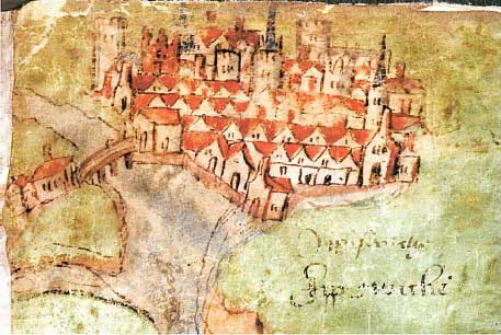
Not
really a map, more an
artist's impression of the town, this picture is a relatively recent
discovery. This is taken from the 1539 Survey of the Suffolk
Coast. The
survey is anonymous, but was commissioned at a time when Henry VIII
feared invasion by the combined forces of France and Spain. He was
aware of the vulnerability of the Suffolk coast and detailed notes are
made about the entrance to the Orwell.
The illustration shows the Orwell/Gipping confluence at Stoke Bridge in the foreground. There appear to be some kind of gatehouse on both the north and south side of the bridge, probably to monitor traffic and impose an entry tax or port charge. The importance of Stoke Bridge as an access point for the town is shown in this picture. The name 'Gippeswiche' (later Ipswich) appears twice at lower right.
Home
Please email any comments
and contributions by clicking here.
Search Ipswich Historic Lettering
©2004
Copyright
throughout the Ipswich
Historic Lettering site: Borin Van Loon
No reproduction of text or images without express written permission
The illustration shows the Orwell/Gipping confluence at Stoke Bridge in the foreground. There appear to be some kind of gatehouse on both the north and south side of the bridge, probably to monitor traffic and impose an entry tax or port charge. The importance of Stoke Bridge as an access point for the town is shown in this picture. The name 'Gippeswiche' (later Ipswich) appears twice at lower right.
Search Ipswich Historic Lettering
No reproduction of text or images without express written permission