Ordnance Survey benchmark
Hardly lettering,
but certainly a symbol...
 2014 images
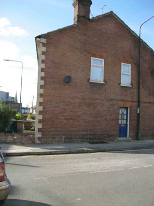
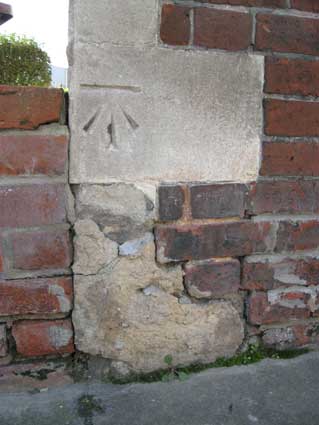
The corner (town side) of Christchurch Street and Woodbridge
Road has a house bearing the familiar quoins at its vertical edge. Many
houses have these made out of bricks and painted to resemble stone
blocks, but these ones are the real thing. The third block up from the
pavement bears the three angled, tapering cuts resembling an arrow
pointing towards a horizontal line.
The term bench mark, or benchmark, originates from the chiseled
horizontal marks that surveyors made in stone structures, into which an
angle-iron could be placed to form a "bench" for a leveling rod, thus
ensuring that a leveling rod could be accurately repositioned in the
same place in the future. These marks were usually indicated with a
chiseled arrow below the horizontal line.
The term is generally applied to any item used to mark a point as an
elevation reference. Frequently, bronze or aluminum disks are set in
stone or concrete, or on rods driven deeply into the earth to provide a
stable elevation point. The height of a benchmark is calculated
relative to the heights of nearby benchmarks in a network extending
from a fundamental benchmark. A fundamental benchmark is a point with a
precisely known relationship to the level datum of the area, typically
Mean Sea Level (see the Ordnance Survey benchmark and 'High Water' mark
on the Custom
House for more information). The position and height of each
benchmark is indicated on
large-scale maps.
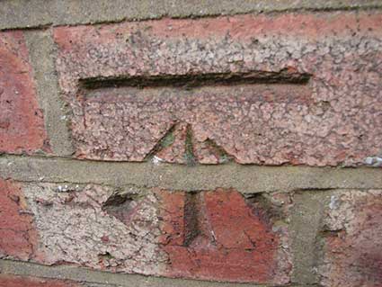 Photograph
courtesy Don Judge
Photograph
courtesy Don Judge
[UPDATE
17.2.2016: "We've got one of those on our house in Leopold Road, pic
attached. I don't know what they used to make the benchmark but it must
have been well hardened and very sharp - our bricks are as hard as
concrete. Don Judge" Thanks to Don for the image. There is an
online Benchmark
locator which shows every O.S. benchmark.]
Ordnance Survey Bench Marks
In the United Kingdom these marks are made by the Ordnance Survey, the
national mapping agency and one of the world's largest producers of
maps. The agency's name indicates its original military purpose:
mapping Scotland in the wake of the Jacobite rebellion in 1745. There
was also a more general and nationwide need in light of the potential
threat of invasion during the Napoleonic Wars, reflected in the
inclusion of the War Department's broad arrow in the agency's logo.
Ordnance Survey mapping is usually classified as either "large-scale"
(in other words, more detailed) or "small-scale". The Survey's
large-scale mapping comprises maps at six inches to the mile or more
(1:10,560, superseded by 1:10,000 in the 1950s) and was available as
sheets until the 1980s, when it was digitised. Small-scale mapping
comprises maps at fewer than six inches to the mile, such as the
popular one inch to the mile "leisure" maps and their metric
successors. These are still available in traditional sheet form.
The Ordnance Survey's original maps were made by triangulation. For the
second survey, in 1934, this process was used again and resulted in the
building of many triangulation pillars (trig points): short (approx. 4
feet/1.2 m high), usually square, concrete or stone pillars at
prominent locations such as hill tops. Their precise locations were
determined by triangulation, and the details in between were then
filled in with less precise methods.
Modern Ordnance Survey maps are largely based on aerial photographs,
but large numbers of the pillars remain, many of them adopted by
private land owners. Ordnance Survey still has a team of surveyors
across Great Britain who visit in person and survey areas that cannot
be surveyed using photogrammetric methods (such as land obscured by
vegetation) and there is an aim of ensuring that any major feature
(such as a new motorway or large housing development) is surveyed
within six months of its construction. While original survey methods
were largely manual, the current surveying task is simplified by the
use of Geo-Positioning Satellite (GPS) technology, allowing the most
precise surveying standards yet. Ordnance Survey is responsible for a
UK-wide network of GPS stations known as "OS Net". These are used for
surveying and other organisations can purchase the right to utilise the
network for their own uses.
Ordnance Survey still maintains a set of master geodetic reference
points to tie the Ordnance Survey geographic datum points to modern
measurement systems such as GPS. Ordnance Survey maps of Great Britain
use the Ordnance Survey National Grid rather than latitude and
longitude to indicate position. The Grid is known technically as OSGB36
(Ordnance Survey Great Britain 1936) and was introduced after the
1936–53 retriangulation.
Although the main O.S. benchmark network is no longer being updated,
the record is still in existence and the markers will remain until they
are eventually destroyed by redevelopment or erosion. Most surveying is
now achieved with satellite techniques although there are still 190
'ground truth stations' known Fundamental Bench Marks (FBMs).
From these FBMs tens of thousands of lower-order BMs were established.
There are probably about 500,000 BMs still in existence in the UK.
Home
Please email any comments and contributions by clicking here.
Search Ipswich
Historic Lettering
©2004 Copyright
throughout the Ipswich
Historic Lettering site: Borin Van Loon
No reproduction of text or images without
express
written permission