Withypoll memorials,
Holy Trinity Priory and its church
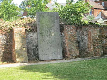
This feature of Christchurch history had escaped our attention,
until Mike Taylor, Senior Conservation Officer of Ipswich Borough
Council, drew our attention to it. The location of this large stone
slab is at the back of a stretch of lawn to the right of the front
elevation of Christchurch Mansion. Because it is set back and, until
recently (July 2019), overgrown by vegetation, many people, we suspect,
missed by many. Mike arraged for the old, overhanging
yews and ivy to be removed (with replanting to follow). Does the
slab hold the key to the story of Holy Trinity Priory and Church?
 2019
images
2019
images
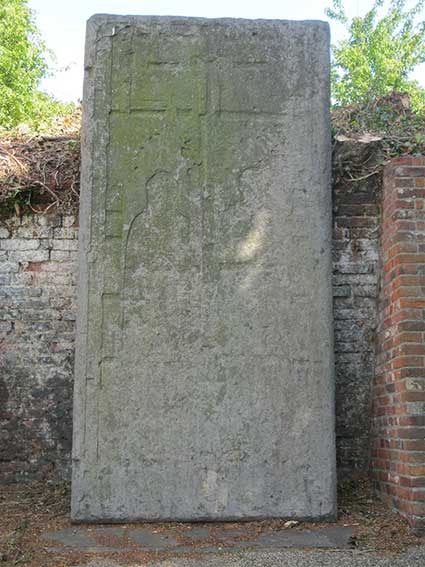
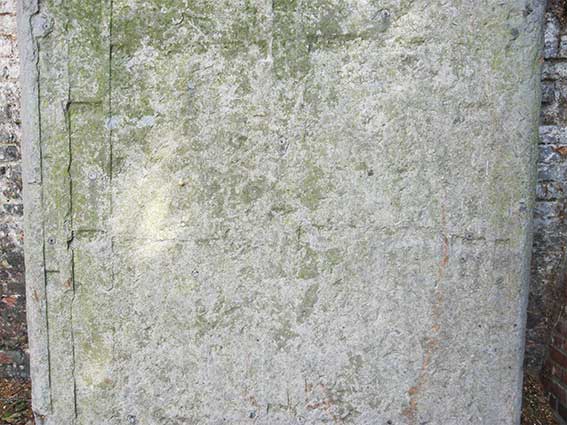
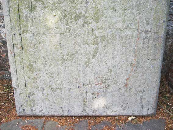
The following photographs scan down the length of the slab. It
is clear that some indentations are still discernible and others have
weathered. 'Laboratory-condition' photography in half-light with raking
light would reveal more.
Richard Edgar-Wilson, Chair of the Friends of Ipswich Museums,
and Carrie Willis, Duty Officer for Colchester & Ipswich Museums,
are to be credited with providing the following information. Our thanks
to them, particularly for bringing to light the 1977 research paper on
the memorial.
Richard writes:
'This is an interesting slab, and yes, the whole history of Holy
Trinity seems peculiarly opaque. I have attached a document I have in
my files called Notes on Holy Trinity
(collected from various sources and not verified) which might possibly
have some information you do not already know.
The go-to person re: the slab would have been the much missed John
Blatchly. But luckily, John wasn’t the sort of person to leave a stone
unturned! Thanks to Carrie Willis, Duty Officer at the Mansion, who in
January [2019] raised the possibility of somehow restoring or at
the very least saving it from the elements, we have this information
which John and Diarmaid MacCulloch wrote in a piece called 'An Ipswich
Conundrum: The Withypoll memorials’ in the Transactions of the Monumental Brass
Society. I have taken the liberty of forwarding Carrie’s précis
here. Incidentally, I wonder whether the William Dandy
mentioned is actually a Daundy,
of Wolsey family fame? I would like to see the slab taken inside. If
not into the Mansion, then perhaps one of our magnificent churches (or
indeed ex-churches).'
"An Ipswich
Conundrum: The Withypoll memorials
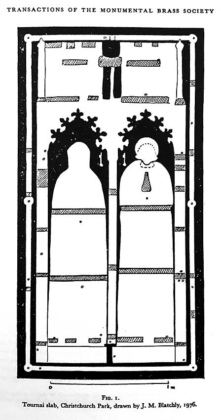
It is a remarkable 14th century brass indent.
The Tournai marble*** slab measures 1.6 metres x 3.16 metres and
although considerably
worn and damaged, it retains the indents of two figures under a double
canopy, all inside a marginal fillet. The figures appear to be a woman
wearing a cowl head-dress on the dexter side and a civilian wearing a
coif on the sinister.
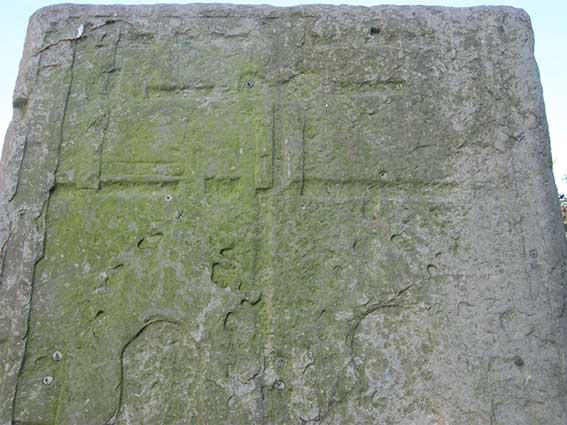
A strange feature of the slab is the presence of two indents of keys
beside the heads of the figures, presumably either a badge of office or
some sort of heraldic or punning device. Prominent also on the
slab are the indents of various backing strips which would be soldered
and riveted to the large areas of brass plate to join them together;
apart from these, only 35 dowel holes are now visible.
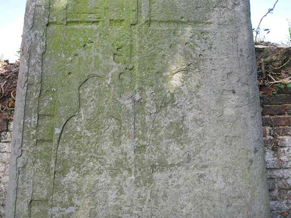
The figure of the civilian also retains a deeper indent of praying
hands to be inlaid in white marble or alabaster, and there are traces,
now indicated only by the greater depth of the surface of the stone
from the plane, of similar indents for the hands of the lady and for
the faces of the two figures. (See the tracing below)
The use of inlay of this sort and of Tournai marble, besides the
general use of the slab, indicates that this is not English work. there
is little doubt that it was made in Flanders, either at Tournai itself
or at Ghent or Bruges; its date is c.1320-30. Such slabs are almost
unknown in England, but in Scotland they are a good deal more
common. It is in Scotland that one finds exact parallels for the
Ipswich indent. These come respectively from Dundrennan Abbey in
Galloway and St John's Burgh Kirk, Perth, and the details of the design
particularly the canopy in both cases is such as to leave little doubt
that they are from the same workshop as the Ipswich slab.
Nothing is definitely known of this slab until 1888, when the local
antiquary Hamlet Watling wrote an article for the East Anglian Daily Times. He
described
the slab as then 'serving the purpose of a doorstop outside the
Conservatory' at Christchurch; this was confirmed 5 years later when
local architect and historian, J.S. Corder, produced Christchurch or Withepole House: a brief
memorial (1893) in which he
mentioned the slab 'without the north door of the present mansion doing
duty for a step' and so illustrated it on his plan. (See the Mansion
plan below.)
It is unlikely that the slab can have been in such a position much
before 1888, otherwise the degree of deterioration would be greater, it
is equally unlikely that it had been a recent arrival at Christchurch,
or else the Victorian commentators would surely have known of its
introduction. Presumably it had been found face down somewhere in or
near Christchurch.
MacCulloch and Blatchly allude to the slab being intentionally used by
Edmund Withypoll as his grave stone in St Margaret's. In his Will of
1568 Edmund instructs 'to bee buried in the chauncell of St Margarets
parishe in Ipswich where I dwell under the northe windowe there with
the greate stone'. Clearly this is a different monument to the one in
the Church as the present slab was placed by Withypoll six years later
and not in the North window but in the centre of the church (now
moved).
Sometime in 1563-5 William Dandy, of Ipswich, bought a law suit against
Withypoll in which he stated that Withypoll had seized land belonging
to his family in Clay Street, now Crown Street. When William
Dandy had gone overseas to persue business he left the land in the
hands of his widowed mother Joan. Edmund Withypoll entered the
premises, pulled down the boundary fence and expelled Joan and the
complainant. Withypoll took away a tenter leased to some cloth
workers 'and also taken awaye one great black grave stone of the value
of xxs thear standing by the said grange and caryed awaye the same to
his owne howse in Yippiswiche'. Is this the slab noted in
Edmund's Will? If so, its rather dubious origins might explain why in
1574 Withypoll decided to replace the tomb of which it formed a part
with an entirely new monument and slab.
If this is the slab we can deduce that the stone came from the Dandy
family. The Dandy family were engaged with Maritime trade with Northern
Europe. Ipswich had long been a centre for trade of mill stones,
monumental slabs, sculptured stones. At Ipswich the dues from imports
of stones had come to be reserved for the benefit of the wardens of the
important borough guild of Corpus Christi. Its important to note that
William Dandy was elected Guildholder in 1555 with Matthew Butler and
William Barker and would thus have been drawing these profits for
themselves. It is probable therefore to suggest that Dandy
acquired the slab from one of these Northern European or Scottish
ports.”
[Based on the article by John M. Blatchly and Diarmaid
N.J. MacCulloch. Transactions
of the Monumental Brass Society, 12, pt.3
(1977), pp.240-7. Accompanying drawing below.]
(***scroll down for a geological opinion on the mineral
involved.)
Notes (second papragraph): in heraldry, 'dexter' is to the
right, 'sinister' is to the left; 'coif': a woman's close-fitting cap.
Notes on Holy Trinity Priory
- The Covent at Holy Trinity was at no time large, it
consisted of a
Prior with 6/7 Canons. In later times the Covent may have had as many
as 20 Canons. The premises at Holy Trinity were not of considerable
size.
- In about 1870 some alterations being made in the Bowling
Green, on the
east side of the Mansion, uncovered the site of the Priory tower. The
foundations were blown up by gunpowder. [Scroll down for a 1780 map.]
- King Edward I visited the Priory on the 8th January 1296
on the
occasion of his daughter's wedding at St Peters. He left 7 shillings
for
his oblation at the Great Altar and another 7 shillings at the Shrine
of relics. [See our King Street page for
an account of this royal wedding in Ipswich.]
- On the 16th January 1296 Lord John de Wickham, on behalf
of the King,
offered to the Priory a silver cup with a foot and cover, weighing four
marks, less 20 pence.
- In 1522 Cardinal Thomas
Wolsey obtained his 1st Bull for
the suppression
of certain
religious houses to aid the funding his college in Oxford.
- In 1528 Wolsey obtained his 2nd Bull for the suppression
of St Peters
and other monasteries for his college in Ipswich. [A Papal Bull is a
type of public decree, letters patent, or charter issued by a Pope of
the Roman Catholic Church.]
- Wodderspoon* and other writers assert that Holy Trinity
was
suppressed
for these purposes. Neither the Inquisition of Cromwell, The Papal
Bull, the Inspeximis of
Henry VIII, nor the Fine with the Dean and Master of the College of the
Blessed Mary in Ipswich, contain any reference to Holy Trinity. [*Memorials of the ancient town of Ipswich
in the county of Suffolk / by John Wodderspoon. 1850.]
- Two later Bulls were obtained, one of which was certainly
comprehensive
enough to have embraced Christchurch, but Wolsey’s fall precluded any
further action under the powers granted to him. The Priory was
eventually suppressed under the Act for the Suppression of the lesser
Monasteries, extorted from Parliament by Henry VIII, in February 1536.
- The Prior undoubtedly received a meagre pension, and the
last glimpse
of him was in the Ministers Accounts
of Norfolk and Suffolk from
Michealmas 1540-1541. It is recorded that the Prior of Holy
Trinity had
died since the last account.
- The land was leased by the King to Sir Humphrey Wingfield
and Sir
Thomas Rushe by deed dated 10th March 1537, for a term of 21 years
at
the rent of £90 19s 4 1/2d.
- The site included, house and site, houses, barns,
edifices, yards,
gardens, orchards, ponds and fishponds – adding up to 643 acres. This
land included the manors of Christchurch, Coddenham, Cretyng and
Stonham.
- The site was bought from Wingfield and Rushe by Sir Thomas
Pope and
sold on to Paul Withypoll for £2,000.
- Within two years of Paul’s death in 1546 Edmund, his son,
started
building. Debris was incorporated from the Priory into the foundations
and wall linings of the Mansion. A Stables and well House were also
built from the spoils.
- 1548 marked the commencement of building; it was seen as a
splendid Mansion
because of the material used: red brick and masonry.
Note that the oldest examples of lettering on this website are
the
painted glass 'Seals of Holy Trinity' which survived the demolition of
the Priory Church which can today be seen in the
vanished church's Victorian namesake: the Church
of Holy Trinity in Back Hamlet.
Christchurch/Holy Trinity timeline
to 1895 (compiled for
the Friends of Christchurch Park).
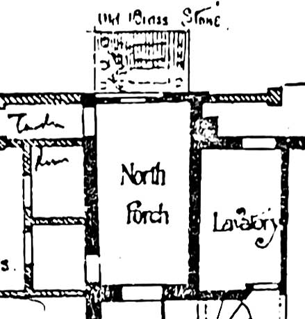
Plan drawing of Christchurch Mansion,
1893
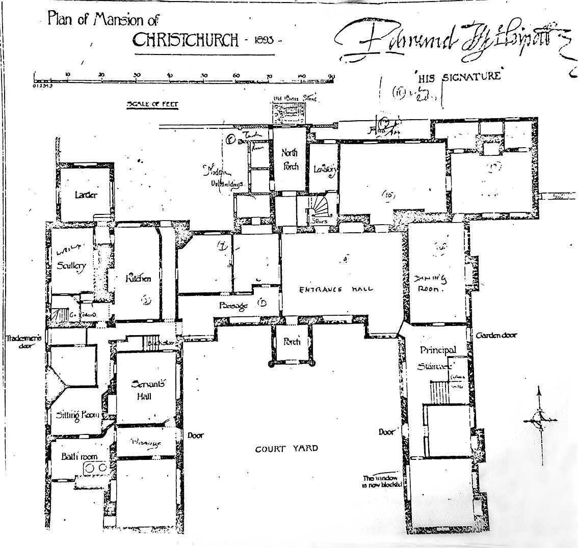
Detail of the plan of the Mansion (built after the Dissolution of the
Monasteries in 1536), drawn by John Shewell Corder (with some hand
additions) showing the position
of the 'Old
Brass Stone' to the north:
 Detail
of the 1893 plan
Detail
of the 1893 plan
The mineral used for the 'Old
Brass Stone'
Caroline Markham of GeoSuffolk: 'Bob and I visited the medieval slab
behind the Mansion this afternoon and it tested (very) positive for
CaCO3. So it is definitely a limestone, which means that Tournai
Marble (which is a limestone) is not precluded. However, the slab is
grey (quite pale grey really) and so does not present as classic
Tournai Marble which, as we all know, is black*. Because it is grey, it
is probably a Carboniferous Limestone rather than the creamy Caen Stone
or Northamptonshire Limestones more common in old Suffolk buildings.
The nearest sources of Carboniferous Limestone are Derbyshire and
Belgium. Belgium could well have been easier for transport at that
time, so the Belgian origins in the document you sent me have some
justification.'
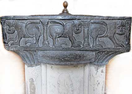
[*The most notable local example of masonic Tournai marble is the 14th
century font at the Church of St Peter, which is dark grey/black in
colour (below).]
Archeaology
The archaeology beneath and around the Mansion could reveal much of the
story and position of the original Holy Trinity Priory and its Church.
Is it possible that the Mansion stands on the site of Holy Trinity
Church itself? The east-west alignments of the Mansion and St Margaret
is striking.
https://heritage.suffolk.gov.uk/hbsmr-web/record.aspx?UID=MSF4957-Augustinian-Priory-Christchurch-Park-Ipswich-SPECULATIVE.-(Monument)
The above link shows the record held on the Suffolk
County Council database for this site and the limited work which has
been done so far.
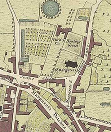 1780
map detail
1780
map detail
The Hodskinson & Jefferies map of Ipswich,
1780 shows the position of the Mansion (here marked 'Chrifts
Church'), south of the Round Pond,
also the Church of St Margaret (built c.1300 as a Chapel-of-Ease to the
nearby
Holy Trinity Priory Church when the congregation became unmanageable in
the original church – now demolished) with the 'Bowling Green'
between them. See note 2 of the 'Notes on Holy Trinity Priory' above
regarding the archaeological discovery c.1870 beneath the Bowling
Green, soon destroyed by gunpowder.
The location of Holy Trinity Priory
Church
[UPDATE 31.7.2019: Mike
Taylor, Senior Conservation Officer at Ipswich Borough Council writes:
'Thankyou for this update, which adds the interesting information about
the location of the church tower. Keith Wade [former County
Archaeologist], the archaeologist on our
Conservation Panel, also thought the church was next to Bolton Lane and
was not a large structure. The timeline mentions a rebuilding and
a royal visit, so it may have acquired size following modest
beginnings. It’s a shame they dynamited the site without recording the
position of the tower – Norman churches often had central towers, and
the choir /presbytery to the east would probably have benefitted from
investment more than the nave to the west (hence perhaps the need for a
completely new church at St Margarets). The evidence is, as you say,
elusive, but I still think the odds are in favour of this stone being
the one surviving fragment from the old church.' Many thanks to Mike for this and for
sowing the seed for this web-page. This will clearly be a mosaic of
small
pieces of information, but we may eventually help in piecing together
the story of the Priory Church and its location.]
'Medieval
It is to the foundation in the 12th century of the Augustinian Priory
of the Holy Trinity that the original existence of the parkland can be
attributed; the park includes a major portion of the precinct of this
significant post-Conquest religious house. It is likely that all of the
buildings within the monastic precinct lay in the south eastern part of
the later parkland and is probable that the priory church lay at least
partially under the mansion. One small archaeological intervention
recorded a small amount of fabric within the mansion whilst tradition
points to the priory church tower surviving well into the 17th century
before being blown up with gunpowder. This tower may relate to a
structure recorded east of the mansion on the earliest maps.
'Some of the landscaping and management of natural water supply still
seen in the parkland lakes and terraces originated in this period.
Early maps demonstrate a sequence of ponds in the western part of the
park, fed by the natural springs that now feed the Round Pond and
Wilderness Pond. Documents indicate that former medieval ponds supplied
the monks with carp, tench, roach and gudgeon. There may also be
substantial components of the priory's water supply system lying
underground in the park. The main conduit is believed to lie between
the water source formerly on Westerfield Road and the buildings of the
priory around the later mansion site, whilst a main drain should lead
downhill from this location. Allen's work on Ipswich's water supply and
Breen's re-analysis of this suggest that a late medieval water conduit
lay just below the ground surface along Dairy Lane, a former street now
subsumed in the south western part of the park. Remains of Dairy Lane,
the conduit, and any other associated structures may survive.
'Post-Medieval
In 1536, during Henry VIII's dissolution of the monasteries, the priory
was suppressed and its estates seized by the Crown. Paul Withypoll, a
successful London merchant, bought the site in 1545 and in 1548 his son
Edmund began to build a house on the ruins of the priory.
'The mid-16th century post-dissolution private house, now Christchurch
·Mansion, is a Grade I Listed Building, being an almost complete and
comparatively unaltered example o f a brick-built house of the period.
'Throughout its long history, Christchurch Mansion belonged to only
three families. In 1645, the estate passed to Elizabeth, wife of
Leicester Devereux, who was the only daughter and heir of Sir William
Withypoll. In 1735, the house was sold to Claude Fonnereau, a wealthy
London merchant, of Huguenot decent. Either he or his son Thomas made
alterations in the early 18th century. A new wing was built on to the
north-east corner to contain a drawing room downstairs and a
magnificent state bedroom upstairs. The bedroom contains some
outstanding rococo plasterwork incorporating the coat of arms. In 1892
Christchurch Mansion was bought by Felix Thornley Cobbold who presented
it to the people of Ipswich. It was opened as a museum in 1896.
'The position of the house in relation to the southern part of the park
strongly suggests that the original 16th-century building would have
possessed formal gardens arranged in front of it to the south. Some
information on the plan of these gardens ought to be recoverable
through archaeological means, including both geophysical survey and
excavation. Historic maps indicate that there were large formal gardens
in the 17th century spanning the whole southern part of the park.
Again, remnants of these may survive.
'In addition the re-working of the monastic water supply to provide
water for the house (and reputedly for a lead-lined conduit to the
town), may well have resulted in the revision of the medieval works,
traces of which will almost certainly lie beneath the ground here.
'The 18th-century rebuild may also have precipitated garden re-design.'
The above paragraphs are an extract from Christchurch
Park, Ipswich: An Archaeological Desk-Based Assessment and
Archaeological Condition and Management Review by
Paul Spoerry (2003, Cambridgeshire County Council commissioned by
Ipswich Borough Council). We are indebted to the Suffolk
County Council Archeological Service for this information.
Christchurch Park, Ipswich: summary
of main points
‘An understanding of this site based only on the map evidence is
misleading. The documentary sources that have been examined for this
report suggest that the northern part of the park beyond the immediate
area of the house cannot be accurately described as a park until the
middle of the 17th century. Before that date the area was pasture, part
of the demesne land of the manor of Christchurch. The boundaries of the
demesne as shown on John Kirby's map of 1735 include lands that had
been part of the demesne of the former priory but the boundaries had
been straightened and fenced by Edmund Withypoll after 1548.
‘In around 1567, Edmund Withypoll had created what is now known as the
Wilderness Pond. Before that date, there were just four ponds all
probably situated in the south-west corner of the park below a terrace
of formal gardens to the west of the present mansion.
‘The entrance to the park from Soane Street was created or enlarged by
Withypoll after he built his house. In order to widen this entrance
various houses were demolished and the boundary of St Margaret's
churchyard altered. The present churchyard walls were built after 1568
and are not the priory's walls. The main entrance to the priory may
have been from Bolton Lane.
‘The conventual buildings were demolished by Withypoll but remnants of
the church tower survived to the early 18th century. Below the building
to the west was a terrace garden and orchards which backed on to the
ponds. The priory buildings probably dated from the late 12th century
with a few later additions.
‘The priory acquired amongst its early the Domesday Church of Holy
Trinity and it is known that some of the priory's founders were buried
within the conventual church. It is likely that the site of the church
and the land to the south includes a burial ground for both the priory
and possibly for the late Anglo-Saxon parishioners of Holy Trinity.
‘The importance of the southern area of the park which has been a
meeting place "Thingstead" since at least the 11th century should be
emphasised. A fair was held in this area from before 1189.
The park's springs have supplied the town with water from the medieval
period, if not before. They were a source for some of the streams which
formerly ran through the town and were later a source for part of the
town's elaborate medieval water system.’
Anthony M. Breen, July 2003
(quoted in Paul Spoerry, September 2003, cited above)
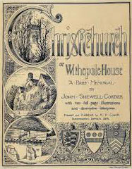
John Shewell Corder's book
 “The seat of Christchurch
derives its name from a Priory of Regular Cannons of S. Augustine,
founded in the Church of The Holy Trinity, a little prior to A.D. 1177,
just without the North gate and Ramparts of the town of Ipswich. On the
authority of Tanner, Holy Trinity was a parish church, and Taylor says
it was originally parochial. In the Domesday Book, Ipswich Half Hundred
on land which Roger Bigot* had charge of in hand for the King, it is
recorded that: “In the said Borough, Anulfus the priest has a church,
Holy Trinity, to which belongs twenty-six acres in alms.” The church, a
small building, abutted towards the East on Thingstede Way since called
Bolton Lane, and the parochial limits were probably co-terminous with
those of the present parish of S, Margaret.
“The seat of Christchurch
derives its name from a Priory of Regular Cannons of S. Augustine,
founded in the Church of The Holy Trinity, a little prior to A.D. 1177,
just without the North gate and Ramparts of the town of Ipswich. On the
authority of Tanner, Holy Trinity was a parish church, and Taylor says
it was originally parochial. In the Domesday Book, Ipswich Half Hundred
on land which Roger Bigot* had charge of in hand for the King, it is
recorded that: “In the said Borough, Anulfus the priest has a church,
Holy Trinity, to which belongs twenty-six acres in alms.” The church, a
small building, abutted towards the East on Thingstede Way since called
Bolton Lane, and the parochial limits were probably co-terminous with
those of the present parish of S, Margaret.
“It was by no means uncommon for a Priory to be established in a parish
church, the nave being left open for the parish altar. This was the
case with the Austin Cannons at Thornton, Carlisle and Christchurch
(Hants), and with the Secular Cannons at Hereford and Chichester.
“It may have been that this church was served by Secular Cannons from
Saxon times.”
[Secular Cannons were much like ordinary priests. They may well have
lived apart, rather than together under one roof – which would explain
the smallness of the Priory; many were engaged in parochial duties.]
“The church, like most Saxon edifices, was not probably a very
substantial structure, consisting as most of them did, largely of
timber, for a few years after [c.1177] it was nearly demolished by
fire, with the adjacent offices. It was rebuilt by John of Oxford,
Bishop of Norwich, formerly Dean of Salisbury and Chaplain to Henry II,
about 1190, who seems this year to have been at his Manor of Wykes
Bishop, whereupon King Richard I. gave the patronage to him and his
successors A.D. 1193-4.”
– Extract from Corder, John Shewell: Christchurch
or Withepole House: a brief memorial.
Cowell, 1893 (copies can
be viewed at Suffolk Record Offices). As well being a noted architect
and architectural illustrator, Corder was clearly an assiduous
historian, too. The plan of the Mansion reproduced above was drawn by
Corder.
[*Roger Bigod (died 1107) was a Norman knight who travelled to England
in the Norman Conquest. He held great power in East Anglia, and five of
his descendants were earls of Norfolk. He was also known as Roger
Bigot, appearing as such as a witness to the Charter of Liberties of
Henry I of England.]
See also the extensive Christchurch
Park &
Mansion page, Christchurch Park Cenotaph, the Ipswich Martyrs monument and the Christchurch timeline.
Home
Please email any comments and contributions by clicking here.
Search Ipswich
Historic Lettering
©2004 Copyright
throughout the Ipswich
Historic Lettering site: Borin Van Loon
No reproduction of text or images without express written permission