King Street / Lion Street / The Golden Lion /
Arcade Street
 2001
images
2001
images
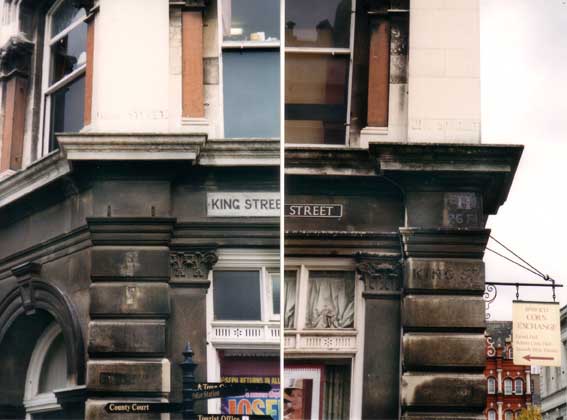
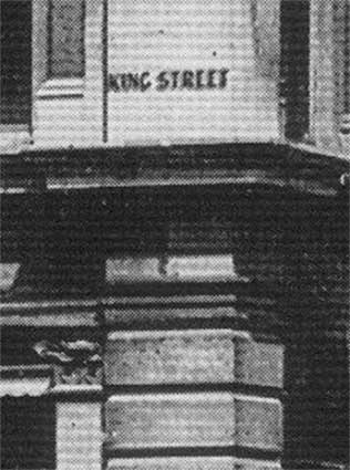
At the Princes Street end of the very
short stub of
King
Street running behind the Exchange
Chambers, we find the
lettered corners
of the building above. The details below
show the enhanced lettering a little better:
'KING STREET'
in bluish
drop-shadow
caps painted over in creamwash also appears at the Arcade Street end
(shown on the left image, above). Also on the Princes Street corner,
darker plain caps spelling out 'KING ST'
on the
block
below are obscured by years of dirt. In between, there is:
'H
26 FT'
indicating the position of a water hydrant. Part
of the
modern metal street sign
can be seen at far left. Below this, against the grubby stonework, is:
'KING ST.'
Upper part of 2001 enhancement (below) – Princes Street end:
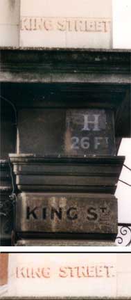 Lower
example is Arcade St end (includes full stop)
Lower
example is Arcade St end (includes full stop)
We're almost certain that this unique surviving
example of painted street name lettering was quite clear and sharp
until
summer, 2003. At this time some swine had painted over the lettering at
each end of King Street with cream masonry paint; the letters are still
just visible. Typical. See the 1910 photograph of this corner below.
[UPDATE May 2015: However, we
just
found the painted lettering 'Lion Street' (without drop-shadow) on the
stonework of the Town Hall; scroll down to see it.]
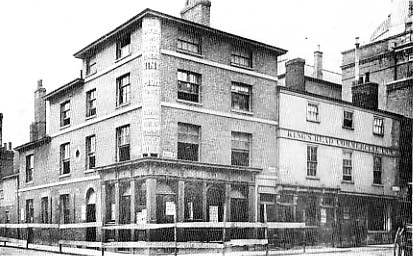
Here is a photograph of the junction of what we now call King Street
and Princes Street (the rear of the Town Hall visible to the upper
right) just prior to demolition of the pub - note the barriers round
the
site. The corner pub, The Sickle (which has the name 'Noble'
above the windows and door on the Princes Street side and was probably
formerly called The Wheatsheaf) will soon give
way to the new Corn Exchange (opened in 1882, see our Cornhill 2 page). It is possible that both
pub names came from the figure of Ceres on top of the first Corn
Exchange nearby which carried a sickle and ears of wheat. Interesting
to see that
the three-storey
right-angle corner
has been built as a curve right up to the roof and is lettered to
advertise the Sickle's wines and spirits and other attractions. Next door is the
'KING'S HEAD COMMERCIAL INN' labelled in a strip above the first floor
windows.
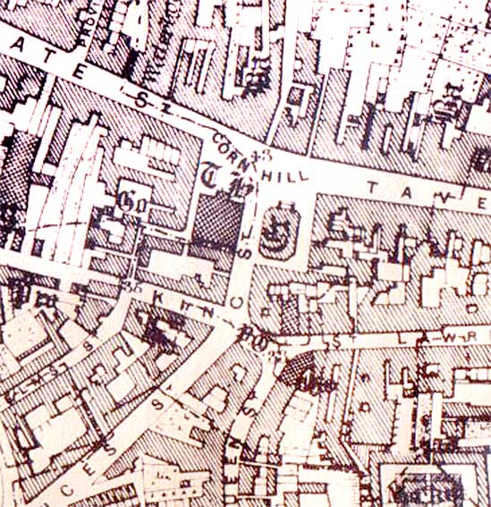
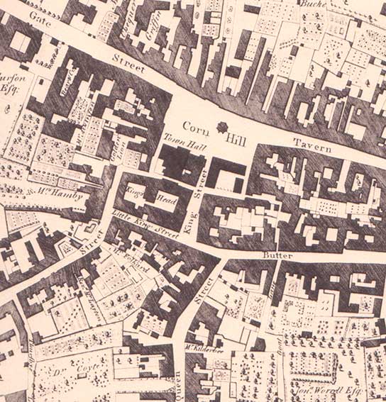 1778 map
Derivation of King Street
The name 'King Street' has wandered around Cornhill
in
a bewildering fashion over the centuries. The present King Street was
Little King Street on Joseph Pennington's 1778
map (detail above). The name may have originated from the
King's Head Inn (opened in 1531 and demolished 1880/1 to make way for
the Corn Exchange), seen in the above view, which was possibly on or
near
the site of a building
called the King's Hall where Edward I (reigned 1272 to 1307) feasted at
the time of the
marriage of his daughter Elizabeth to the Count of Holland in 1297. So
the King's Head, which appears to occupy the whole footprint of the
future Corn Exchange on the 1778 map, may
have been named after
the ancient 13th century hall***. See the following caveat:-
‘Although the Cornhill retained its name, the long
roadway to Stoke Bridge saw some changes. Until the late eighteenth
century, it was King Street. Parts of the street had their individual
names, Sennicolastrete 1344, St. Peter’s Street, 1761, which seems very
late, Bridge Street and Queen Street, 1778. But the name King Street
clung to the upper part of the street until it eventually became part
of Princes Street. Even then the name was not lost for what had been
Little King Street or Lower King Street became King Street. It is
tempting look for a particular royal connection, in which case Edward
I, whose visit to the town during the winter of 1296-7 was full of
colourful incident, and with whom an otherwise unknown King’s Hall is
associated, appears to be the likeliest candidate. Regretfully, it has
to be said that the name King Street is often a mistaken rendering of
of the familiar ‘king’s highway’ (vicus
regis). It may be so here.’ [Clegg, M. Streets and street names in Ipswich
(see Reading list)]
A passageway on the line of the Thoroughfare ran
westwards between the rear of the Moot Hall (or Town Hall) and the
King's Head, which is shown on the map as a continuous building with
two central courtyards. This was one of the town's most ancient inns:
one of only twenty-four to appear on a town assessment of 1689. It was
a notorious venue for cock-fighting in the 18th century. These premises
were listed in the 1844 White's Directory, with carriers operating from
the inn to Bergholt. By 1865 it was called the Old Kings Head. Note
that the Market Cross (removed in 1812) is clearly shown at the upper
centre of the 'Corn Hill' in 1778. The old Shambles, at this period
showing signs of decay, was directly south of the Market Cross,
replaced by the Rotunda, the first Corn Exchange and eventually by the
Post Office building. Immediately east of the Palladian-fronted Moot
Hall on the Cornhill were two buildings: an old pub originally the
Three Tuns Inn but more recently named The Corn Exchange Tavern, and
Richard Cole’s shop.
***Here's a
fascinating article from The Ipswich Society Newsletter, July
2018 (Issue 212) by Trevor
Cooper:-
Royal wedding at Ipswich, 1297
In the year of a royal wedding [2018], it is appropriate to remember an
earlier royal wedding which took place in Ipswich, 721 years ago.
However, Ipswich was not an obvious place for a royal wedding; there is
a shortage of information and disagreement over the actual date and
location in the town.
On 8 January 1297, Elizabeth of Rhuddlan, the daughter of King Edward I
and Eleanor of Castile, married John, Count of Holland at St Peter and
St Paul’s church, Ipswich, now known as St
Peter’s by the Waterfront. In attendance at the marriage were
Elizabeth's sister Margaret, her father, Edward I King of England, and
her brother Edward, (later King Edward II). Queen Eleanor was already
dead. The great nobles of the land and the low countries would also
have been in attendance.
There is a rival claim to the location of the wedding: the now
demolished Chapel of Our Lady, which until
the reformation was a chapel on the corner of St Matthews Street and
Lady Lane. It was a major site for pilgrimage; its attraction was the
miraculous healing powers of the statue of The Virgin Mary. It is
likely that the actual wedding took place in the larger church of St
Peter, but that the royal party made a devotional visit to the Chapel
of Our Lady as part of the overall wedding proceedings.
Elizabeth was 15 when she married, and her husband was 13. The marriage
with Count John was dynastic and political. Holland had close trade
links with England. They were betrothed when John was only 1. As part
of the agreement, John was raised in England at Edward’s court;
effectively a hostage for his father’s continued allegiance.
The context for this wedding was a complex proxy military and trade war
between England and France, involving Holland and Flanders. The essence
of the conflict was substantially about Edward’s control of Gascony,
which was the remaining province of England’s possessions in France,
and his assertion of control over Scotland. In both areas Edward was
being challenged by France. It was a great power conflict between
England and France, which drew in the Low Countries, because it was
also about control of the wool trade. Wool was England’s main export
and the greatest source of tax revenue.
By the time of the marriage, John’s father Floris V Count of Holland,
had been murdered in a botched kidnap attempt in 1296, because he had
changed allegiance in favour of France. Edward I was implicated, but it
is unclear how much he was actually involved. Edward condoned the
murder as it suited his purposes: he now had the successor, John Count
of Holland, in his power.
The marriage between Elizabeth and John would have become very urgent
and was brought forward to immediately after the Christmas feast.
Edward would have been keen to establish his control over Holland
through John who would become his son-in-law, to stabilise the
all-important wool trade, and secure the alliances against France. King
Edward invited a number of nobles from Flanders with English
sympathies, to witness the wedding and the king’s power in the Low
Countries. After the wedding John of Renesse (one of these lords) was
appointed regent by Edward I, on behalf of John count of Holland who
was a minor.
St Peter’s in Ipswich would have been chosen as the location for the
wedding for symbolic reasons. In medieval times Ipswich was an
important trading town and port it was crucial to the economic and
political power of the country. In particular it was the major cloth
and wool exporting port for England. The wool trade was an important
source of royal revenues through taxes on exports. Edward probably
chose Ipswich to demonstrate his power over the wool trade to the
French, his own people, and his allies.
It was an Augustinian Priory of St Peter and St Paul which occupied a
six-acre site. As a large priory, it would have had the necessary
buildings to accommodate the king and his retinue. Much of the town
would have been taken over for the lodgings of other notables and all
the attendant clerks, servants, soldiers, priests and others, as
guests or functionaries.
Importantly for this event was that it was easily accessible by sea. It
is likely that the king, his retinue and the bride and groom travelled
by sea; it being quicker and easier than by road. The royal ships would
have been able to moor very close to the priory, where College Street
and Key Street are now, which would have been the original quay. The
foreign guests from Holland and Flanders would have found it
conveniently accessible by sea. It is of course also possible that the
king travelled by road from London after the Christmas feast. It is
likely that much of the king’s baggage and retinue travelled by road
and arrived ahead of the wedding to prepare the accommodation at the
priory, and to finalise the arrangements for the wedding. The royal
baggage train would have brought everything for the king’s comfort;
furniture, the king’s bed, tapestries for wall hangings, plate, clothes
jewellery.
After the wedding John, Count of Holland, was sent to Holland to
establish his authority as ruler, although he was made to promise to
heed the council of Edward’s Regent: he was effectively under the power
of Edward I. Elizabeth was expected to go to Holland with her husband,
but did not wish to go, or Edward I did not want her to go; it is not
clear.
Elizabeth did join her husband in Holland in 1298. Edward I travelled
with her, through the Low Countries with her two sisters Margaret and
Eleanor. This can readily be seen as a royal progress with Edward
demonstrating the extent and reach of his power. They remained for
several months and celebrated Christmas there in 1298.
On 10 November 1299, Count John died of dysentery, though there were
rumours of his murder. No children had been born from the marriage. His
usefulness to Edward had been served. Edward had negotiated a peace
treaty with France. To seal that, Edward himself married again to
Margaret, the half-sister of Philip IV, King of France.
Elizabeth is only connected with Suffolk through this marriage. She was
born at Rhuddlan, north Wales in 1282, and died in childbirth, in 1316,
and was buried at Walden Abbey, Essex. She was born in north Wales
because Edward was at war with the Welsh rulers of Gwynedd, and Eleanor
of Castile his wife was accompanying him as she always did.
But for all this, we have a royal wedding which took place in Ipswich
for strategic reasons: these explain its choice for a royal wedding.
When Elizabeth married her second husband, Humphrey de Bohun, earl of
Hereford in 1302 it was at Westminster Abbey.
 1867 map
Edward White's map of Ipswich, 1867 shows
the same area with some notable changes. The block of "The King's Head"
of 1778 is now fragmented into thre separated blocks and we know that
the Sickle stood on the lower right corner, so the King's Head would
appear to have occupied only the upper right building – directly behind
the Town Hall: an indication of a business in decline. The building
east of the Town Hall shown here (the legend is 'Cx') is the first Corn
Exchange awaiting demolition around 1880. The grand Post Office
building we see today was opened in 1882 on the footprint of the
demolished 1810 Corn Exchange. On the map we sees a post office (marked
'PO') at the end of Butter Market, facing the top of Queen Street.
Street names have changed by 1867 and King Street now goes eastwards
from the Arcade (and end of Elm Street) and turns north up to the
Cornhill. Butter Market, as shown on the 1778 map, is here labelled St
Lawrence Street.
[UPDATE
2008/2009: the Corn Exchange was clad in a
work of art. This took the form of a sunny cornfield against a blue sky
printed on plastic sheeting covering the scaffolding. Sadly, this meant
yet another coat of masonry paint, finally killing off some of the King
Street lettering.]
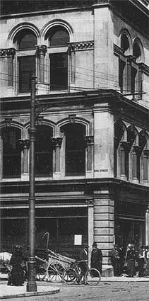
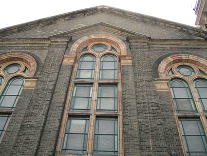
 Close-up, 1910
at right
Close-up, 1910
at right
Above: the junction of Princes Street with King Street to the
left. The painted, drop-shadow capitals are clearly shown above the
cornice in a view of the Corn Exchange's corner c.1910. For another
example of a street name painted on the Town Hall stone see 'Lion
Street' below.
Lion Street
 2015 images
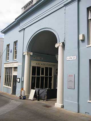
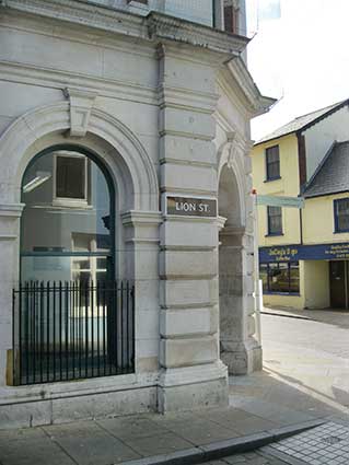
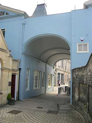
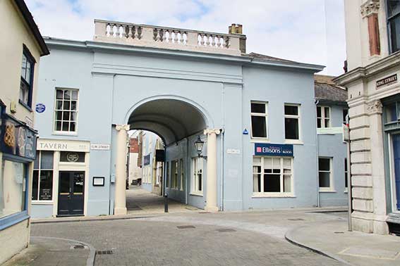
The west end of King Street today is the confluence of three streets:
Elm, Arcade and Lion. The photograph of the arch above shows all three
street nameplates, plus the Ipswich Society blue
plaque for Jean Ingelow.
While many Ipswichians might think of the lane beside the Town Hall
which comes out in King Street as "Golden Lion Passage", it is actually:
'LION STREET.'
and this tiny,
bendy alley is signed four
times.
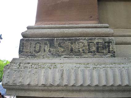
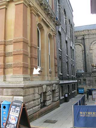
In 2015 we finally noticed the black
capitals, complete with square full stop, spelling out the street name
painted at the base of the square pilaster of the Town Hall (arrowed in
the above photograph). Praise be that the contractors working on the
cleaning of the building's fabric left this tiny detail intact.
Because today's Town Hall was built on the site of the Moot Hall,
itself an adaptation of the Church Of St Mildred (built around AD700,
so Anglo-Saxon in origin), this little lane was once known as 'St
Mildreds Lane'. As we find from the CAMRA information about The Golden
Lion, elsewhere on this page, it was later known as 'Town Hall Passage', presumably post-1868, when the present
building was opened. The only query is that perhaps this latter name
was applied to the narrow passage which used to run behind an earlier
Town Hall on this site linking Golden Lion Yard with the Thoroughfare.
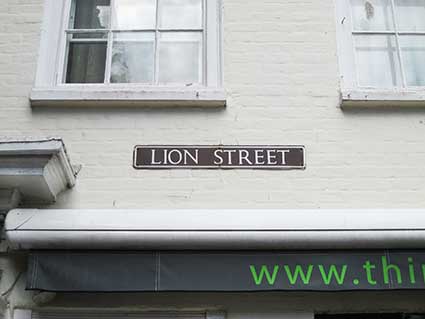
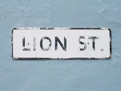
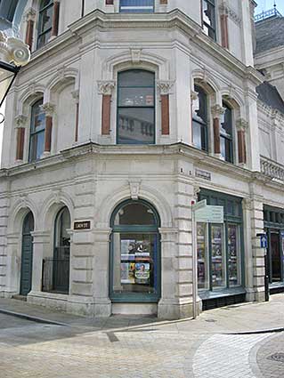
Lion Street is named at each end by the modern street nameplates
bearing serif'd capitals on a dark brown background. Left: the wall of
the Golden Lion Hotel, now a noodle restaurant. Right: the corner with
King
Street; this nameplate has the addition of a full stop.
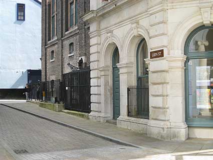
Public lavatories at the Corn Exchange
[UPDATE 22.6.2016: 'The sign "Lion Street" on the
rounded
corner with King Street in the right-hand picture – arched doorway and
window with iron bars – it used to be the most wonderful
Victorian-style public loo! As a child in the 1950s I would ask to go
in there at every visit to town because it was so pretty – lovely
tiles, shiny brasswork, I would spend far too long in there, I loved
it! My father was not so happy with it as he had to wait for me
outside for long stretches. I have often wondered what happened to it.
I have long imagined it to still be there behind the scenes, awaiting
rediscovery, though probably not, knowing the Council. Yes, [there was]
an underground Gents loo: the railings along Lion Street, on the back
of the old Corn Exchange, look over and down, all still there! There
was
often a very bad-tempered loo-attendant in the Ladies, she would watch
me with deep suspicion!
I am a Collings from Norfolk & Suffolk. In King Street, the old
Sickle Inn was kept by my Great Grandfather's cousin, Nathaniel Sterry
in the 1860s; he died there in 1869. My Great Grandfather, George
Sterry, kept The Blooming Fuchsia, The
Sorrell Horse, and beer-houses in
Alan Road. My Granny, Grace Collings, née Sterry, kept The Three Tuns
in Commercial Road, and the Kings Head in East
Bergholt. I was
especially interested in your pages on Alan
Road and Rosehill Road as
that is where these folk purchased houses. My father, Alan Collings,
was born at 119 Rosehill Road, one of his grandparents’ houses; it's
probably how he got his name***! My Collings Great Grandparents
purchased
one of the small holdings on Foxhall Road: 2 Lincoln Villas; they ran a
market garden, it is gone now sadly. They were the parents to P.
Collings, grocers at Whitton and Castle Hill shops. So, your website
has been very interesting to me. Your website is EXCELLENT! Thank you.
Lin Jensen.' Many thanks to Lin for
this memory – does anyone else recall the Victorian public toilets on
this corner of the Corn Exchange?]
*** See our Street name derivations
page for 'Alan Road'.
See the period photograph of the Moy Coal Office Arcade below for
conclusive proof about the toilets.
 2016 images
Above left: the corner entrance which used to be the Ladies public
convenience (taken from under 'The Arcade'); above right: those
railings
around the basement space of the Corn Exchange in Lion Street.
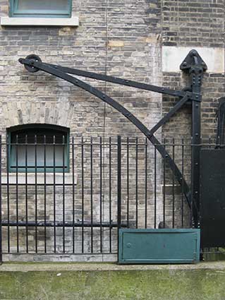
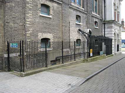
An interesting swing-winch in cast iron is still situated behind the
railings, presumably once used to load supplies for the Corn Exchange from the lane and
down into the area below. Right: the locked gate which would have
enabled access to the underground Gentlemen's public convenience – it's
quite a long way down those narrow steps. Below: let's not forget to
look up at this elevation of the building. Away from the stone-faced
frontage on King Street is a rather simple, attractive combination of
white and pink brick details with romanesque arches and
circular/half-circular windows. This is seldom noticed by passers-by in
the narrow Lion Street.
Golden Lion Yard
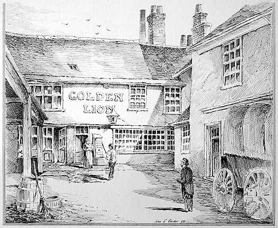 1898
image
1898
image
John Shewell Corder appears elsewhere in this website: building
historian, architect and illustrator of Ipswich, also son of Frederick
Corder whose department store ran between Tavern Street and Butter
Market (today's Waterstone's shop). His 1898 illustration shows the
coaching entrance of The Golden Lion, from Golden Lion Yard. The 2021
photograph shows it in a sorry state, definitely the 'back yard' of the
hotel with intrusive metal fire escape, relying on its hotel entrance
on Lion Street/Cornhill (see
below).
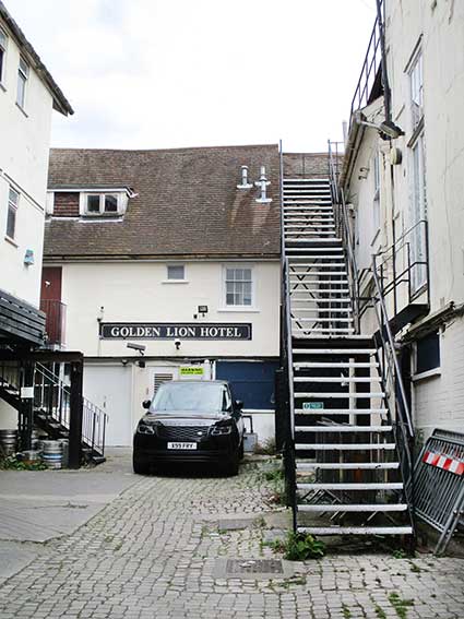 2021
images
2021
images
It is notable on Pennington's 1778 map, a detail of which is
shown on our King Street page, that Elm
Street appears to run up to Golden Lion Yard. One assumes that this
would be the access for post coaches. The legend 'Golden Lion' appears
on the map actually in the yard, rather than on Cornhill. Below: the
limesone setts are in largely good condition. Compare with Coytes Gardens.
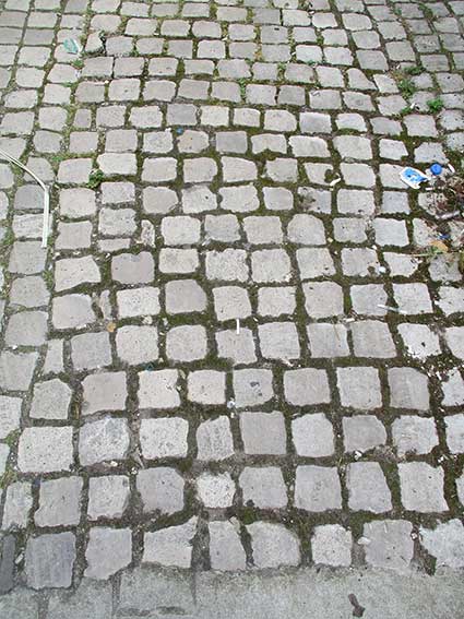
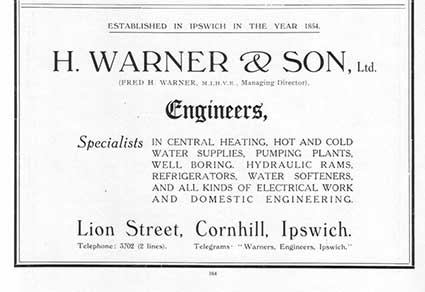
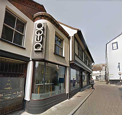
8 Lion Street
Below: a somewhat surprising advertisement from
1936 promoting a
plumbing company with premises in the relatively tiny Lion Street. H.
Warner & Son
Ltd. were based in the Grade II Listed, 17th century building at 8 Lion
Street; today it is a restaurant (in 2023 The Moloko) just north of the
arcade. The company adjusts the date at which it was founded from 1854
to 1845 in the 1963 advert – or it could be a typo? One online resource
states that there are company records from 1859 to 2004.
 1936
advertisement
1936
advertisement 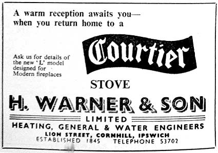 1963 advertisement
See our Street furniture
page for a ground-level casting by the company.
Below: a 2019 view of the former premises of H. Warner & Son
Ltd. which stood opposite the Borough's public lavatories – perhaps
appropriate for a plumbing company. Golden Lion Yard is visible in the
background.
 2019 image of 8 Lion Street
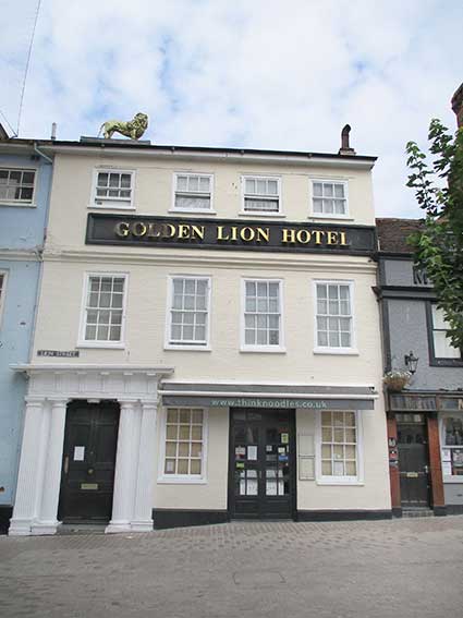
The Cornhill frontage
The large sculpture of a lion on the rooftop stands over the main door
into the
hotel. In 1960 a photograph shows three windows to the right (Suffolk
CAMRA website, see Links). These days a
restaurant is accessible by an additional entrance, but the interior
lobby of the hotel can still be identified. Also from CAMRA:
'Originally called the White Lion, the name changed during the 1570s.
According to Alfred Hedges' book Inns
and Inn Signs of Norfolk and Suffolk (1976), the inn here dates
from about 1400.' This building is Listed Grade II and a former posting house, located in one corner
of
the historic Cornhill. Once it stood
beside the moot hall, today it is
dwarfed by the Victorian Town Hall. Originally the whole hotel complex
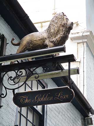
formed the Golden Lion as the large roof sign suggests. The lion statue
was once gilded; small remnants of this gilding still remain. The small
public house called The Golden Lion with its entrance in Lion Street
was open until 2019. CAMRA adds: 'The Golden Lion Tap was listed
separately from the Golden Lion in the 1861 census. The 1916 Kelly's
Directory lists the Lion Hotel Vaults in Town Hall Passage (no
further
information), which may refer to this establishment.'
 2021 images
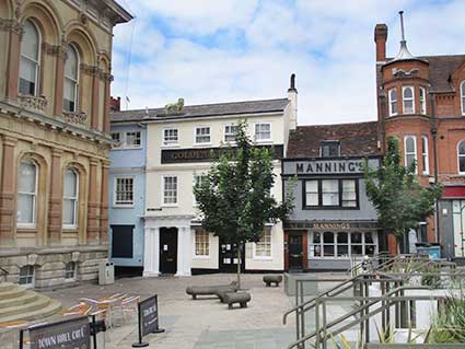
Above (from left): the Town Hall western
corner, the blue
painted Golden Lion pub, the Golden Lion hotel, the noodle restaurant,
Mannings pub and the southern part of Grimwade's store.
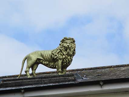
The golden lion atop the building certainly appears to have been
repainted at some point and doesn't look at all bad.
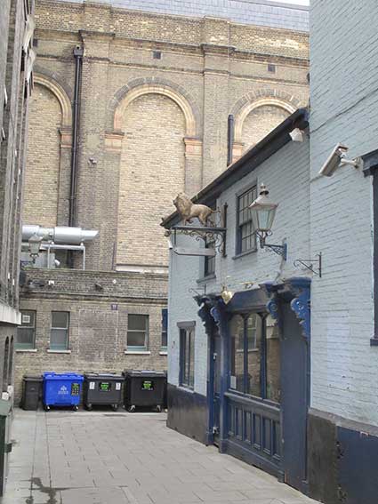
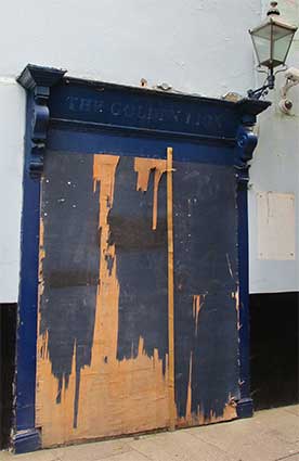
Looking down Lion Street, we see the former Wetherspoon's public house
featuring a small golden lion – presumably put there by that company
with the pub name beneath, The boarded-up window has the name 'THE
GOLDEN LION' painted over above.
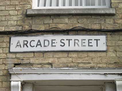
Arcade Street
 2016 images
Above: on the other side of the Arcade (which is more correctly an
extended arch, or a short tunnel). At the west end of Arcade Street is
a pressed metal nameplate attached to a curving Suffolk white brick
wall, which is in need of some repair. This particular building has the
distinction of playing host in the story of the struggle for women's
suffrage. It used to be the office of the Ipswich branch of the Women's
Freedom League. It was here that the suffragette and tax resister,
Constance Andrews, was feted following her release from Ipswich Gaol in
St Helens Street after refusing to pay her dog licence.
'The Mansion'
Before the street was cut through, the building was a town house
known as Don Read's Mansion; it marked the end of King Street. John
Norman in one of his informative Ipswich
icons columns in the local press (Lives lived in the shadow of our town hall
21.1.2018) writes:
'The mansion was bought by the East of England Bank in 1836, who
installed William Ingelow as banker. It was an extensive six-bedroomed
property with a 20-foot-square banking hall and a similar-sized dining
room. His family lived there and an Ipswich Society blue plaque
commemorates daughter Jean, a poetess. In 1845 the East of England Bank
failed and in 1848 the house was extensively remodelled, with an arch
being cut through into a new street. This ran to the corner where the
new museum was being constructed and then up to Westgate Street.'
 2021 image
Here is the view from King Street with Elm
Street to the left and Lion Street to the right. Horse-drawn
coaches would have approached the Golden Lion coaching yard from here.
 Early
20th century photograph?
Early
20th century photograph?
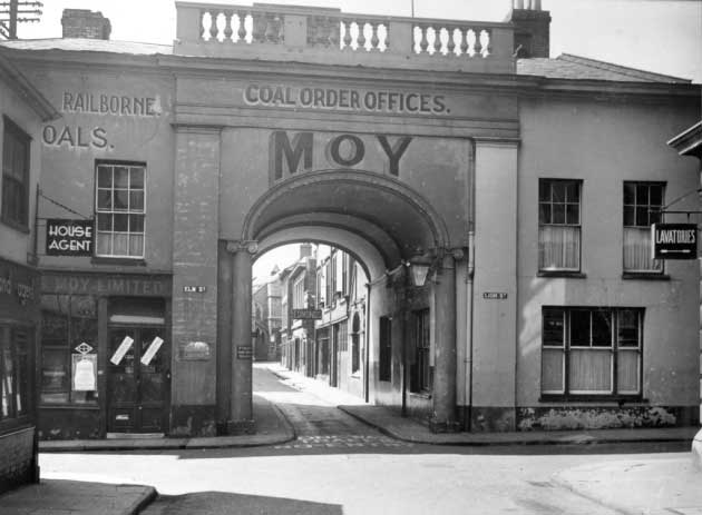
This above photograph was taken by William Lovell (who was the chief
librarian with the East Anglian Daily Times Company for several
decades) via the excellent David Kindred column Days gone by. The revelation
that the 'arcade' at this point was used as a billboard for the coal
company is surprising and one wonders if the lettering still lies
beneath today's layers of masonry paint. It looks as if the signwriter
has executed his work on the cement render of the remodelled building.
'... RAILBORNE.
... [C]OALS.
COAL ORDER
OFFICES.
MOY'
The capitals all bear a drop-shadow with the huge 'MOY'
varying in size to closely follow the curve of the arch. The
reversed-out street nameplates ('ELM ST. AND LION ST.)
on either side of the arch are a bonus – today they have modern
replacements in the same positions – as is the hanging 'LAVATORIES'
(probably a lit glass sign?) on the corner with Lion Street, proving
conclusively that
the Borough provided public toilet facilities here (see above). Not
something that can oft
be said today...
The shop sign at the left reads: '... MOY LIMITED'
 1870s
advertisement
1870s
advertisement
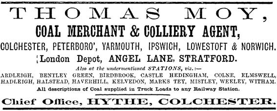
Moy was by far the biggest coal merchant in
East Anglia. At Derby Road railway station in
east Ipswich there were sidings on either side of the line. These were
mainly used by coal merchants: Rowland Manthorpe, E. A. Stow and Thomas
Moy Ltd, amongst others.
Thomas Moy stabled their horses in the yard and for many years this was
still the most common means of delivering coal to households.
Incidentally, the curious word 'RAILBORNE' seen to the upper left
refers to coal brought by rail, as opposed to 'sea coal', brought by
ship. It appears that 'rail-borne' was conflated into a kind of brand
name.
[UPDATE 29.5.2023: spotted on
Facebook, a William Vick photograph taken c.1890 (not shown here) of the same scene. The upper,
horizontal lettering reads in capitals 'JAMES
HARRISON & SON.' and running all the way around the arch in
condensed capitals: 'MANUFACTURING
CABINET-MAKERS.' – all with drop-shadow. Incidentally, the
corner property at left at this time was a public house: The Hermit was
situated at 7-11 King Street and closed in 1922; it has since had a
variety of uses as an estate agents and coffee bar.]
The original function of the opening here – Arcade Street having been
built as an escape from Museum Street before the latter was extended to
meet Elm Street – is shown by the narrow vehicle access, made narrower
by a pedestrian pavement on each side. On the tarmac, to be read from
the King Street side, are the white letters: 'ONE WAY TRAFFIC, NO
ENTRY' (just readable in the photograph).
 2023 image
courtesy Sandy Phillips
2023 image
courtesy Sandy Phillips
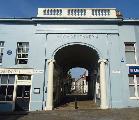
'ARCADE
[STREET] TAVERN'
Sandy Phillips was cycling towards the arch in April
2023 when she noticed and photographed the lettering painted on the
rendered and blue-washed surface above. Quite a long ladder (or
scaffolding tower) would have been required by the signwriter, we
think. Or it may have been applied to the uneven surface as a vinyl.
The small caps of the word 'STREET' are turned through 90 degrees and
bracketed by two vertical rules in the centre. This is an excellent
view directly down Arcade Street with part of the Museum Street Methodist Chapel frontage
visible at the end.
 2018 images
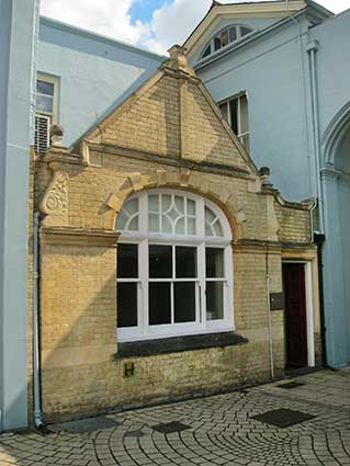
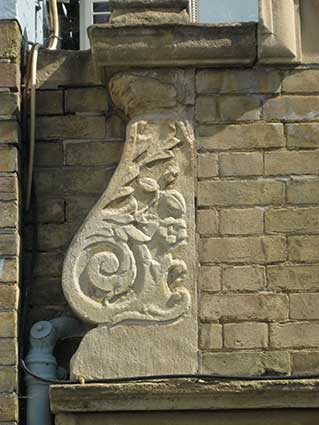
There are some interesting buildings in Arcade Street, often
overlooked, perhaps. Passing through the arch, and opposite the beer
garden of the bar fronting Elm Street (once the Moy coal office), there
is the building shown above at 2 Arcade Street. At the time of writing
2 to 6 Arcade Street is occupied by Blocks Solicitors. This
perfectly-formed little white brick building features ball finials over
the rather good carved supports, one of which is shown above. The
window with its decorative arch is pleasing. It must date from the
1840s to 1850s when Museum Street and Arcade Street were cut through
(see below).
Further down the street, past the modern Ipswich County Court – the
faded royal coat of arms appears on our Blue
plaques page – stands the long-empty hall which was opened as the
Scout Headquarters in April 1964. Its Art Deco frontage resembles a
cinema and attempts to convert the building into a bar and restaurant
have come and gone. Dated rain-hoppers
can be seen on the other side of the road.
Arcade Street and Museum Street are
full of sizeable Victorian houses. As the professional businesses which
have occupied these premises for fifty years move out, the buildings
are set to return to residential use.
Street evolution
When Joseph Pennington made his map of Ipswich in the 1770s, the area
between Westgate Street and Elm Street was entirely taken up with
gardens, but in the 1840s plans were made for a new street linking
Westgate and Elm streets. An opening for the new thoroughfare was made
through part of what had been Seckford House. Thomas Seckford
(1515-1587) built his mansion at this site, sometimes known as 'the
Great Place' or 'the Great House', such was its prestige. See our Lost Ipswich signs page for the 'Before
Willis' section: more on the streets in this area and an engraving of
the impressive Seckford House. The new street ran south as far as the
new Ipswich Museum, designed by Christopher Fleury opened in 1847.
Today this is Arlington's Restaurant. The street hugged the Museum,
taking a sharp left turn and heading eastwards. However, it did not
connect with the Lion/King/Elm Street junction until 1850 with the
cutting of the 'Arcade' through one of the houses (lived in between
1834-1844 by novelist Jean Ingelow – see our Blue
plaques page). In 1856 Thursby's Lane (up to then linking Friars
Street northwards to Elm Street) was
extended to a junction with Museum
Street. The east-west part of Museum Street was then renamed Arcade
Street and the whole north-south street from Westgate Street to Princes
Street – including the kink at the Arcade Street junction which we
see
today – was renamed Museum Street. The tiny stub of Thursby's Lane
between Princes Street and Friars Street stayed until the building of
the Willis building in 1975, when roads were reshaped or lost.
[Information from R. Malster: Wharncliffe
companion, see Reading list.]
Bell bollard
 2023
images courtesy Sandy
Phillips
2023
images courtesy Sandy
Phillips 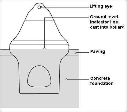
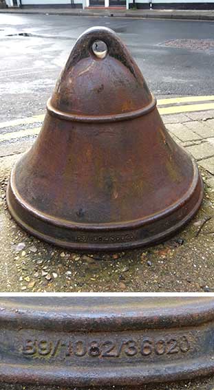
Above: 'Walking down Arcade Street this morning [March
2023], past the arch towards Museum Street, I spotted this Bell, no
manufacturer name that I could see. Sandy Phillips.' Thanks to Sandy
for adding to her contributions of images of drain and other
ground-level castings (see also our Cocksedge
page). These 'bell bollards' by a company called Furnitubes and are
there to protect pedestrians and buildings from heavy goods vehicles.
If heavy vehicle was to begin mounting the pavement the wheels of
the vehicle would be deflected away from the pathway and back onto the
road. Note in the diagram the amount of the casting buried underground.
Another bell bollard can be seen in St Stephens Lane, outside Doug
Atfield's The Sun Inn. We hear that Doug
installed the bollard to protect his fine 15th/16th century building
from heavy
lorries delivering goods to the rear of stores in Upper Brook Street
(then C&A and Sainsburys), to the dipleasure of the authorities.
It's still there.
See also our Street furniture page
which draws together links to other bollards on the websit;, included
there is a 2023 photograph of a rectangular variation on the bell
bollard.
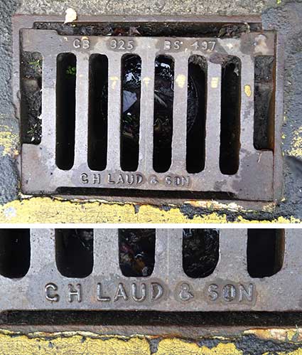
Below: 'Past the bell bollard, towards Museum
Street,
there is a drain each side of the road: G. H. Laud & Son, not an
Ipswich Co. Sandy Phillips'. G. H. Laud &
Son were a
Liverpool foundry.
Related pages
Our Cornhill1 and Cornhill 2 pages feature notable dates
in its history and a more detailed survey of the changes over time,
including King Street.
See our Museum Street
page for 1778 and 1902 comparative maps including this location.
Crown & Anchor / Westgate Street
Lady Lane,
Civic Drive
Salem Church / St
Georges Street
Princes
Street
Friars Bridge Road
Coytes Gardens
Museum Street
Methodist Church
Black Horse Lane
Ipswich
Museum
Street nameplates
Historic maps
Street index
Street name derivations
Home
Please email any comments and contributions by clicking here.
Search Ipswich
Historic Lettering
©2004 Copyright
throughout the Ipswich
Historic Lettering site: Borin Van Loon
No reproduction of text or images without express written permission