Lower Brook Street Tacket
Street /
Rose Lane / Rosemary Lane / Dykes Street
Price The Bootmaker
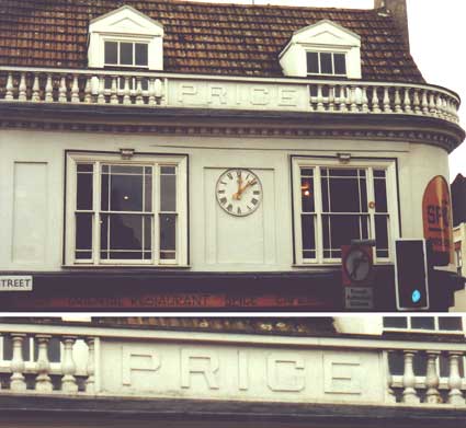
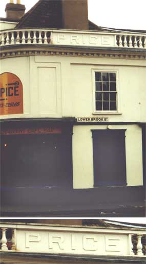
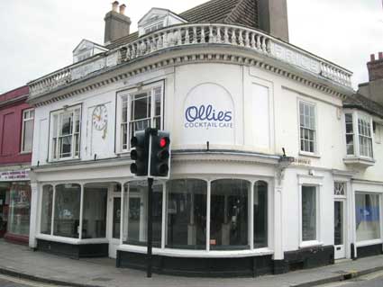
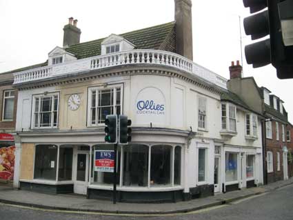
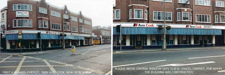
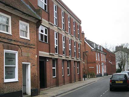
The shop at the corner of Tacket Street and Lower Brook
Street is quite
a distinguished landmark run by J.F. Price. 'PRICE', the boot and
shoe seller occupied
this
attractive building for many years and the lettering integrated into an
upper balustrade on both faces commemorates this (below left, Tacket
Street; below right, Lower Brook Street). The building has
been a restaurant or bar – or empty – for a number of years.
 2001
images
2001
images
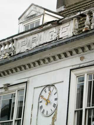
For a century the shop was known as Price's Boot Shop with the
boots hanging on the outside of the shopfront like hands of bananas. It
is Listed Grade II. The listing suggests a date at the end of the
nineteenth century and this is confirmed by the Suffolk Directories. In
Kelly's of 1892 (Part 3) p 1321, Price's address is given as 2 Tacket
and 1 Lower Brook Street, while in the Post Office Directory of 1869
(Part 3) p. 987, only Tacket Street is listed.
The Listing (Grade II) text reads:
"1260 LOWER BROOK STREET (East Side) Nos 1 and 3 TM 1644 SW 3/309 II 2.
Including No 2 Tacket Street. A timber-framed building with a pleasant
mid-late C19 plastered front with a quadrant corner, a continuous
balustraded parapet with name panels and a stucco modillion cornice.
The building has fronts on Lower Brook Street and Tacket Street and
projects into the line of Upper Brook Street making an effective visual
stop to the south end of the street. 2 storeys, attics and cellars. 5
window range overall, 2 3-light double-hung sash windows with margin
glazing bars on Tacket Street and one double-hung sash window with
glazing bars, in flush cased frame on Lower Brook Street. The premises
include a 2 storeyed timber-framed and plastered building (No 3) with 2
3-light oriel bay windows under a wide overhanging eaves. The ground
storeys have C19 shop fronts. Roofs tiled, (C20 on Tacket Street)."
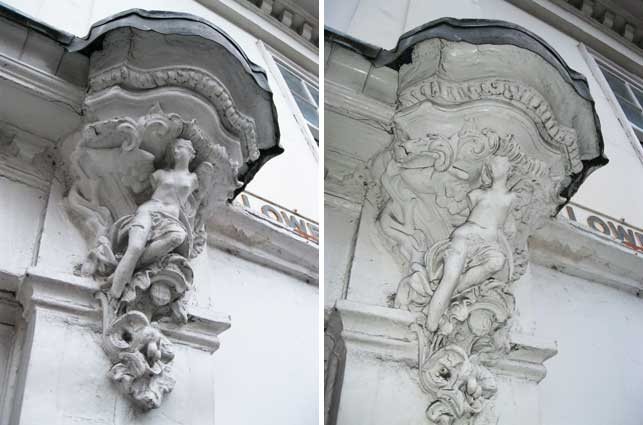
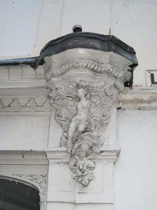
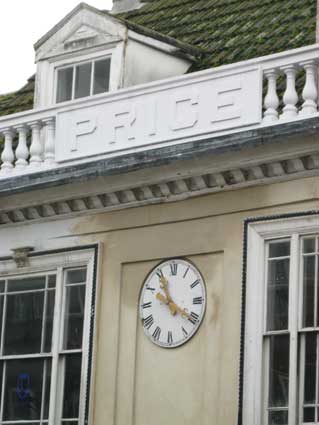
Incidentally, the decorative moulding, replete with
scantily clad nymph close to the Lower Brook
Street metal street sign is the figure of Fame
or 'Winged Victory'. The figure is set on a capital
beside the
curved window on the ground floor. Fame
seems an oddly triumphant choice of decoration for a successful
Victorian boot shop. The images below are
'without flash' and 'with flash' to pick up the detailing, despite
layers of paint.
 2013 images
This is certainly an Ipswich curiosity and is not repeated
elsewhere on the Price premises. It does not look as if it has been
cleaned or repainted during the 2013 renovation of the upper parts of
the shop. There is an image on the Ipswich Society's Flickr
collection of this detail and it is
painted black, which doesn't seem right at all...
[UPDATE
23.4.12: The sad state of the Price lettering in 2012 has to be
recorded here. The Roman numerals on the clock face look pretty good
but the owners of this property are letting the balustrade and its
lettering go to rack and ruin. Shame.]
 2012 images
By 2013 the 'PRICE' panel on the Tacket Street elevation had,
along with some of the balustrade, rotted and fallen onto the roof. The
word is that this building will be refurbished back to its
original state. The photograph below shows the process starting.
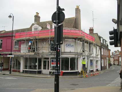 2013 images
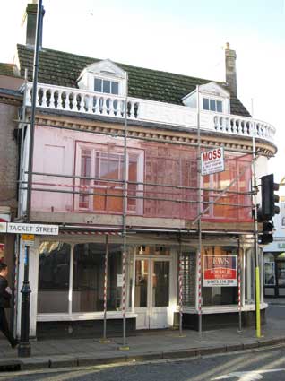
And finally (below right) the scaffold is
removed, the beautiful clock – it seems to be working – is returned to
its place and
the wall made good by early 2014. The whole building has not been
refurbished and work is still needed on roof and dormers at the front
and the Lower Brook Street elevation, by the look of things. But we
must be grateful for small mercies.
 2014 images
See our page on Public clocks in Ipswich for a 2018 view of the
building and its clock.
It's just down
the road from Christ
Church Congregational Church, The
Unicorn
in Orwell Place, and not far from the CTC
roundel on the old Coach & Horses, also the
Symonds
sign in Upper Brook Street.
 Photographs courtesy The Ipswich Society
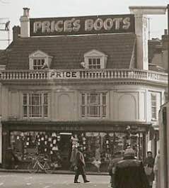
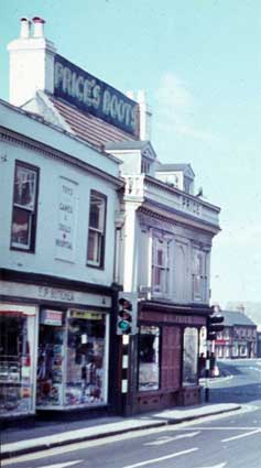
The detail above from a 1970s view of Price's found in The
Ipswich Society's Flickr image archive (see Links)
shows the shop in all its pomp with a huge board fixed between the two
chimney stacks, beautifully painted with:
'PRICE'S BOOTS'
in metallic-effect, drop-shadow, sans serif capitals
similar to those relating to the store along Tacket Street: E. Brand & Sons, the sign for which
can be seen in Ipswich Museum. Another
photograph showing this sign can be found on our Old Cattle Market page in the section
tracing the site of Sir Thomas Rush's house.
Note the premises to the left: the blank window above E.P. Butcher's
shop features the lettering:
'TOYS
–
GAMES
&
DOLLS
*
HOSPITAL'
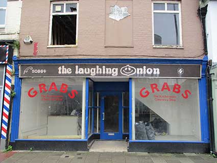
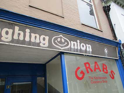
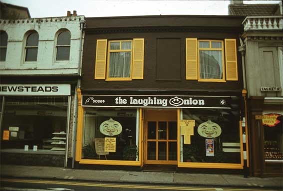
4 Tacket Street
UPDATE 20.6.2021: ’At no. 4
Tacket Street the former ‘Grabs’ discount kitchenware shop is being
renovated and they have currently exposed the late 70s/early 80s
‘Laughing Onion’ café signage. A bit of research shows someone traded
there as the ‘Blinking Owl’ afterwards. James Meek.’ Our thanks to James for noticing this
reappearing shop sign, soon to be covered up, no doubt.
 2021 images
Above: the shop front next door to Price's. This has certainly
been painted by a signwriter; the weathering is making the cream paint
run.
Ed Broom reminds us that there is a 1978 photograph of these premises
on the Ipswich Society's Image Archive (see Links):
 Courtesy
The Ipswich Society
Courtesy
The Ipswich Society
Ed reckons that the sign says:
'HOT SOUP TO TAKE AWAY - 10P'. Newsteads Bakery is next door – from a
time where many streets boasted an outlet for the local baker; it was
later home to Victoria's Bakery, until that branch closed. In the shop
windows are reflections of Avis Cook Televison & Audio across
Tacket Street. At this time Price's were still in business, as proved
by the shoe display to the right.
[UPDATE 10.8.2021: 'Wasn’t it
the Porthole Coffee Bar in the 1960s? Maybe was it the Keyhole before
or after that? Jean Cater'. Thanks,
Jean.]
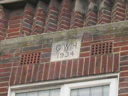
1-5 Tacket Street
Across Tacket Street (see Street
name derivations) from the Price shop is a
deco-style block which bears, above the central bay, a
tablet bearing the characters:
'G.W.H.
1934'
 2013 images
These photographs (perhaps from the 1980s) show the shops
as many will recall them. Avis Cook electrical and hi-fi dealers once
had a shop on Major's Corner; the buildings in the narrow wedge of land
between St Helens Street and Old Foundry Road have long gone. John
Bulow-Osborne points out: "You are probably aware that the lettered
insert seen elsewhere on your site, denotes that the building was
constructed for the chemist G. W. Hales." We are grateful to John for
the additional information. 'Hales Chemist'
still exists as a doorstep mosaic in St Helens Street. They also had a
shop in Wherstead Road.
See our S. Wilson, cutler
page for some photographic prints produced by 'G.W. Hales, Photographic
Chemist'.
 Photographs courtesy John Bulow-Osborne
John writes: 'The Avis Cook ones are self-explanatory. I worked as a
service technician for them a number of times, from 1960 onwards,
before they moved from High Street to Tacket Street. We had a large
service department in Dyke(s) Street, with a staff of around thirty.'
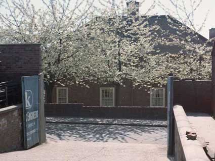
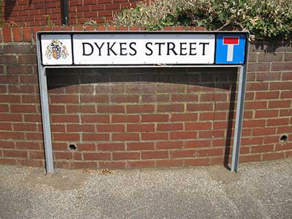
Dyke(s) Street
While we're looking at the Avis Cook shop, let's recall their workshops
in Dykes Street, off St Georges Street, now replaced by the three
storey High View House. Dykes Street is also the site of a possible St
Margaret's parish boundary...
 Photograph
courtesy The Ipswich Society's image archive
Photograph
courtesy The Ipswich Society's image archive
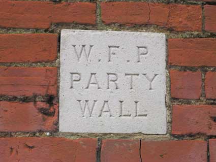
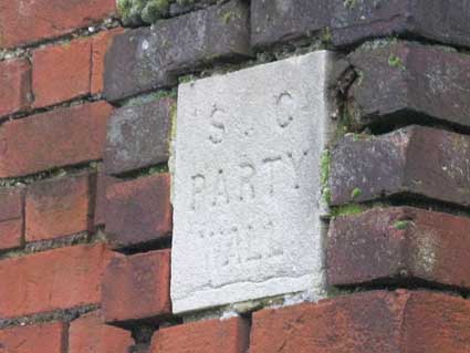
... also, two curious lettered tablets, one on each side of the old
wall beside High View House:
 2014 images
'W.F.P.
PARTY
WALL'
'S.C.
PARTY
WALL'
If anyone knows what these
initials stand for, do email us.
 2018 image
Sometimes the smallest roads have more street signs (compare, for
example, Lion Street off Cornhill ans Parkside Avenue) than the wider, longer
thoroughfares.
Dykes Street has two prominent street nameplates, on on each side, but
is only a few yards long, before it narrows to a back lane accessing
parking and gardens of houses in Berners Street.
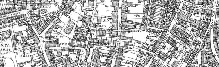
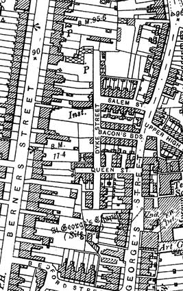 1902 map
Above is the map detail from 1902 of the area. At this time (and in the
1930s), maps show the road as 'Dyke Street' (singular). The northern
part of the street extends much further and the east-west part is named
Salem Street, after the nearby Salem Chapel.
South of this are Bacon's Buildings and Queen Street. The last two
disappeared with all the terraced houses around them with the building
of housing here, probably in the 1960s. Below the original Queen Street
junction, on the west side of St Georges Street, are handsome three-storey houses with stone steps up to the
front doors. Just below and to the west of them
on the map is labelled in Gothic characters: 'St George's Chapel (Site
of)' which gave the
street its name. Today Dykes Street largely serves as a back lane
serving the rears of properties on the east side of Berners Street. The
change from singular to plural is intriguing enough to include in our Street name derivations page.
Local resident, Francis Beaumont: "Queen Street ends at the bottom of
my garden. When I bought my house in 1971 there was the remains of a
wall which went right across Nos. 48, 50 & 52. There was one exit
into Queen Street, my garden was a few feet shorter than the other 2,
and we all had a gate into the tiny rectangle which was then enclosed.
This was presumably used for 'night soil' etc. In the modern curved end
of Dyke Street at our rear there was always a dip in the lane – no
matter how often it was filled in. We presumed that there had been a
well there."
Dogs Head Street
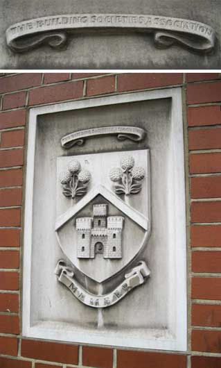
On the opposite corner to the Price
lettering:
'THE BUILDING SOCIETIES
ASSOCIATION
MEMBER'
 2012 image
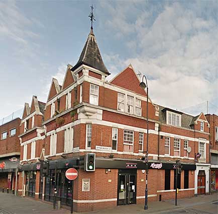 2016 image
This is on the corner of Upper Brook Street
and Dogs Head Street on the
turreted building once occupied by the Ipswich Building Society, later
rather ignominiously a '99p Shop'; even worse, the 99p Shop went out of
business. The carved stone panel is on the 45 degree-angled wall on the
corner at street level (to the right of the No Entry sign in the above
photograph).
See our Princes Street
page for 'Mutual
House' on the corner of King Street: the town centre branch of IBS from
2018.
See our Dogs Head Street page for
illustrations of this building and its predecessor, the Dogs Head in a
Pot Inn.
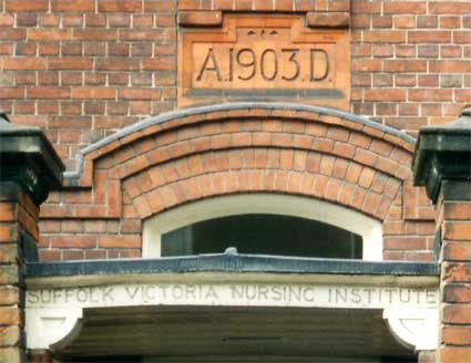
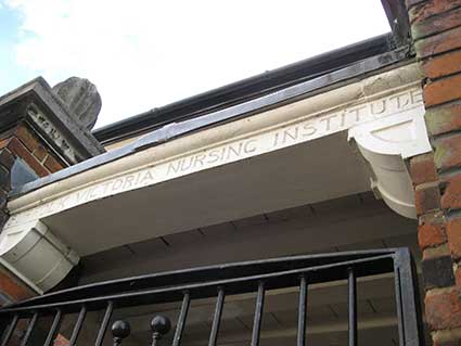
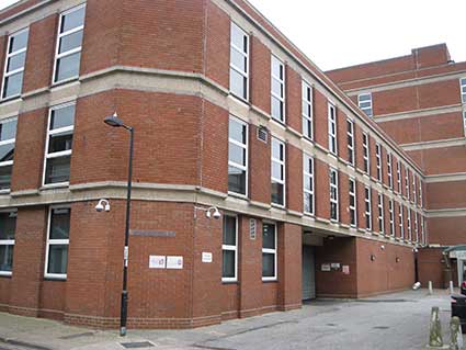
7 Lower Brook Street:
Suffolk Victoria Nursing
Institute
Then a little further down Lower Brook Street on the same side there's
the
little-noticed, but quite impressive, entrance to:
'SUFFOLK VICTORIA
NURSING INSTITUTE'
The awning leading from the front pillaster to the
door
bears the incised name and, very prominently, the date 'A.1903.D.' in a
terra
cotta tablet above it.
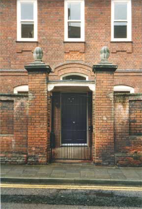
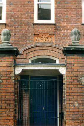
As far as we can tell, this is now a private residence.
The Ipswich and East Suffolk Hospital in
Anglesea Road was the town's main hospital from 1836 to 1988 with
maternity cover on other sites including The Ipswich Maternity Home in
Lower Brook Street.
From the 'Kindred Spirits' website (see Links) we read the following fascinating
historical note.
"An incident in Ipswich in July 1851
resulted in the town being banned from seeing members of the royal
family visit the borough for seventy-five years.
The problem arose during a visit of
Prince Albert to Ipswich in July 1851 to attend the annual meeting of
the British Association [at Ipswich Museum] and to lay the foundation
stone at Ipswich School the following day. Somewhere along the route,
six words shouted out in broad Suffolk by someone in the crowd, were to
have a disastrous consequence. “Goo hoom, yer rotten ole
Jarman.” Albert probably did not understand but courtiers
reported this to the Queen on return to Buckingham Palace and Victoria
banned visits to the town. No member of the royal family came to
Ipswich for the next three-quarters of a century.
In 1902 the directors of the Mid
Suffolk Light Railway planned a branch line that would link Debenham
with Ipswich. The Lord Lieutenant of Suffolk was on the board and the
Duke of Cambridge, first cousin of Queen Victoria, came by train to cut
the first sod at Westerfield Junction. Because of the necessity of
keeping Ipswich out of the ceremony a marquee had to be put up on the
railway land for 600 guests. The Duke’s first sod was also the
last. Not a yard of track from Westerfield towards Debenham was ever
laid and shortly thereafter the promoter of the whole scheme went
bankrupt.
Almost exactly a
year later the Suffolk Victoria Nursing Institute was inaugurated as a
memorial to Queen Victoria. It was opened in Lower Brook Street by
Victoria’s third daughter Helena. She came not as British Royalty
but as German: as Princess Christian, wife of HRH Prince Christian of
Schleswig-Holstein.
After the death of King Edward VII in
1910, county memorials to him were planned throughout the land. The
first to be completed was Suffolk’s, the Ipswich
Sanatorium at
Foxhall. People looked forward to a Royal opening but those in the know
realised this would not be possible and invited Lord Balfour of
Burleigh to perform the ceremony in June 1912.
King George V in the earlier years of
his reign was often a guest at shooting parties at Orwell Park but the
Royal Train from London always passed through Ipswich and Derby Road
stations without stopping.
In 1926 Prince Henry came to Ipswich
to open an exhibition celebrating the bi-centenary of the
artist’s birth ending a long royal displeasure."
 2014 image
This building was commonly known as 'Ipswich Maternity Home' in later
years.
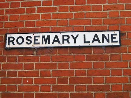
Rosemary Lane
 2016 images
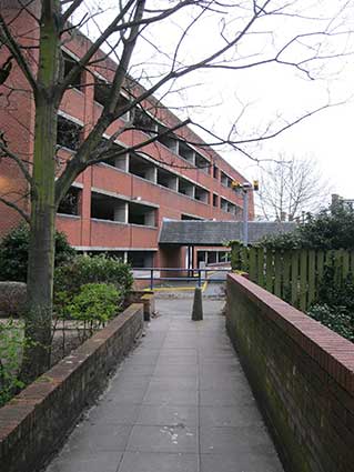
South of the modern Peninsular House, the side wall of the Georgian
house at 15 Lower Brook Street bears a fine cast iron street nameplate:
'ROSEMARY LANE',
but is a very different place today from previous centuries. The 1902
map
shows that it ran from Lower Brook Street through to Foundation Street,
close to Richard Felaw's House (demolished in the 1960s, shown at the
bottom of our Almshouses page). About
half-way down this lane, Wingfield Street
once cut in at a right angle. It is, more or less, represented by the
pedestriain walkway along the angled western side of the multi-storey
car park fronting Foundation Street (which was eventually built on the
site of Richard
Felaw's house).
 1902 map
of the southern route of the 1958 Ring-Road
1902 map
of the southern route of the 1958 Ring-Road
The Ring-Road that never was (see
our Ipswich
tomorrow page for a full article and images)
There is, of course, an untold story here. The twentieth century
Peninsular House and Foundation Street multi-storey car park which
today define the north side of Rosemary Lane were built in the spirit
of a radical 1958 scheme by the Borough Council to build a dual
carraigeway Ring-Road through the town. Part of the central
Government's scheme to resettle from London's East End huge numbers of
new residents in the south-west of the town, the ill-fated Greyfriars
complex, Civic Drive and St Matthew's roundabout replaced housing in
and around the area called The Mount. Unfortunately for Ipswich (but
fortunately in the long run), the plug was pulled on this initiative,
probably due to the decision to build Milton Keynes (other
re-settlements of east Londoners at Great Cornard, Haverhill, Thetford
and other places went ahead).
Rosemary Lane lay on the proposed path of
the new Ring-Road and, after demolition of the period buildings at 17 Lower Brook Street, Peninsular***
House was built and still
bears the shamfered corner which would have fitted round a large
roundabout as the road cut a swathe through 17th century buildings in
St Nicholas Street, Silent Street, Turret Lane, Lower Brook Street
and Foundation Street, carrying away the only surviving
remains of a monastic house in Ipswich: Blackfriars. This also caused
the demolition of Richard Felaw's 15th century house in 1964 (as
discussed on our Tooley's Almshouses
page). The huge, red
Turret Green Baptist Church (shown on our Sailors
Rest page) can be seen between Silent Street and Turret Lane. It
would undoubtedly have stood in the way of the proposed Ring-Road, but
was actually demolished in 1977, apparently due to a declining
congregation. Thus the proposed Ring-Road cast a very long
shadow. [*** One for the pedants... 'peninsular' with an extra
'r' is the adjective
relating to the noun 'peninsula' meaning a piece of land bordered on
three sides by water, but connecting on the fourth to the mainland,
e.g. the Shotley peninsula.]
Above left: the modern Peninsular House at no. 15, the gap near the
street lamp of Rosemary Lane and, south of that, the Georgian frontage
of no. 15, then the modern Haven House (see photograph of the frontage
below), built to accomodate Her Majesty's Revenue & Customs
regional staff.
Above right: the 45 degree chamfer on the corner of Peninsular House
indicating the site of the proposed Ring-Road roundabout here.
Above left: between
the rear sections of Peninsular House and Haven House, Rosemary Lane
squeezes through the gap as it did on the 1902 map and, of course, well
before that. The alleyway here would have been closely lined with
buildings on both sides.
Above right: after a sharp right and left turn to navigate round the
multi-storey car park site one reaches another of the very historical
sites in Ipswich belied by its modern appearance. In the foreground the
higgledy-piggledy, patched together old walling. Behind that, the huge
rear section of Haven House. This is the site of St Edmund de Pounteney
(or St Edmund Pountney)
chapel, one of the town's earliest (now lost) churches. Prior to the
building of Tooley's Almshouses
('The Foundation') in 1552, Foundaton Street had been known as St Edmund Pountney Lane, then 'Christ's Hospital Lane'. The
Foundation Street name was firmly in place by 1745. Ogilby's map of
1674 labels it as St Edmund Poontny Lane'.
St Edmund de
Pountenay chapel
(Haven House)
St Edmund of Abingdon (the village in Oxfordshire in
which he was born c.1175) is also known as St Edmund of Pontigny (the
place of his burial) or Edmund Rich, saintly Archbishop of Canterbury
(from 1234). Eight years after his death he was canonized. The
linguistic corruptions of 'Pontigny' into 'Pountney' extends to a
mention of the chapel as dedicated to 'St Edmund of Ipswich' (1302) And
'St Edmund de Pontiaco'. The chapel was probably established around
1290. The rectory (later known as 'le
Stonehouse' or 'the Stonehouses') stood at the
junction of Rosemary Lane and Lower
Brook Street and the churchyard extended towards Foundation Street. The
variants on the saint's name are manifold; satisfyingly, 'St Edmund de
Punkeney' in 1730, by which time the building was
described as 'a former chapel of ease to the Church of St Helen' – the
latter still
standing today in St Helens Street. In fact it had ceased to be an
active religious establishment by 1588.
Partial archeological excavation in 1975 revealed the information shown
in the map below. It is likely that the original churchyard extended
further to the east.
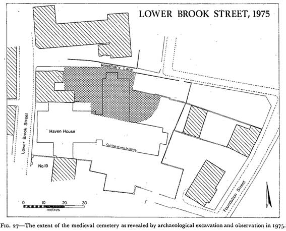
Information on the chapel taken
from a The Suffolk Institute of Archaeology and History research paper
by Muriel Clegg: 'The
Chapel of St Edmund Pountenay in Ipswich'.
See also the map detail from Pennington's
map of Ipswich 1778 on our Wolsey
College page which shows Rosemary Lane at that date and surrounding
streets and gardens.
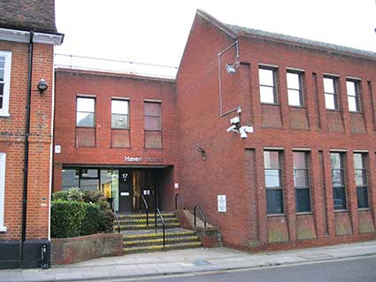
Above: the frontage of
Haven House, facing the end of Turret Lane;
the relatively modestly-sized frontage on Lower Brook Street belies the
extent of the building behind it.
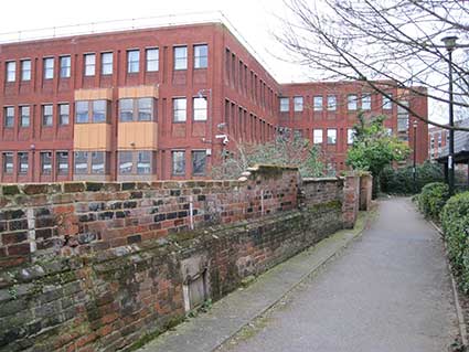
Rose Lane
It is only a short walk from here down Lower Brook
Street, right into Turret Lane and then
into Rose
Lane. Here is a piece of
industrial
architecture (photographed in 2001) which had a facelift in 2003 as a
companion
building to the rebuilt Brights furniture shop on St Nicholas Street
(close
to a very pristine-looking Victorian, multi-sided pillar box). The building bears a
striking resemblance to those on the Wet Dock, for example Christy's
warehouse, part of which is now The Bistro on the Quay.
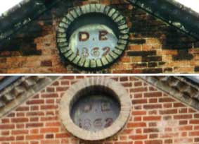
 2001
2001
 2003
2003
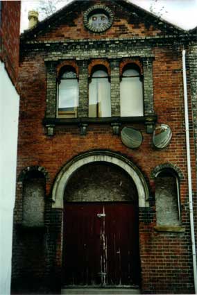
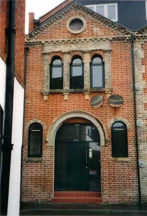
The recessed circular plaque set so very high up in
this very narrow lane
reads:
'D.B
1862'
(no second full stop after the 'B'). The photograph
of
the cleaned up version above shows the extended new building behind.
The
convex traffic mirrors have been reaffixed at right of the fascia,
however
they appear to be cross-eyed ...
This building is more or less on the site of Curson
House, see Curson Lodge for more
information.
Home
Please email any comments and contributions by clicking here.
Search Ipswich
Historic Lettering
©2004 Copyright
throughout the Ipswich
Historic Lettering site: Borin Van Loon
No reproduction of text or images without express written permission