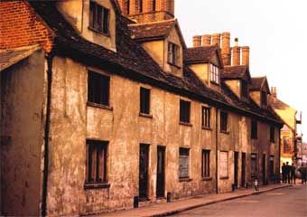
Tooley's and Smart's Almshouses, Foundation Street, Richard
Felaw's House
For comparative maps of Foundation Street (1778,
1867 and c.1881) see our Courts and yards
page.
The street is named after the 'Foundation' or
almshouses –
originally built in 1552 – and Christ's
Hospital (established in
1572 in the old monastic buildings, namely the Frater, of the Dominican
Friars; the
Hospital
was, in fact, an amalgamation of foundations, including the first
buildings of what went on to become Ipswich Grammar School – see
'Richard Felaw' at bottom of this page). Prior to
that, it was known as St Edmund Pountney Lane after the chapel of that
name which once stood on Rosemary Lane, between Foundation Street and
Lower Brook Street (more detail and
photographs can bee seen on that page). Foundation Street
was earlier home to the
Dominican Friars (Blackfriars), the
ruins of whose church
are still visible next to The Unicorn
Brewery:
 2017 image
Moving southwards, we pass Blackfriars Court, a modern sheltered
housing complex (visible on the far left in the above photograph).
Across the entry
which used to be called Tooley Street (see the 1902 map below), is the
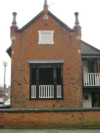
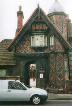
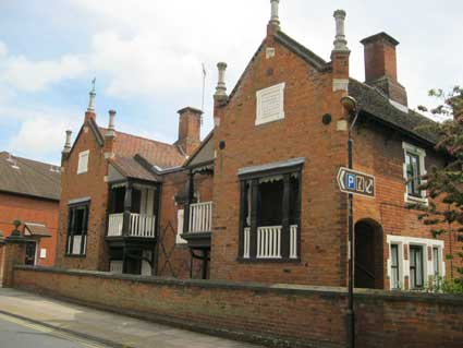
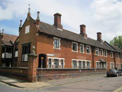
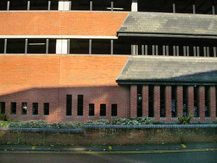
corner of Tooley's & Smart's Almshouses. 'The
original Tooley's and Smart's Almshouses were rebuilt in
1846, designed by architect John Medland Clark: a big group of redbrick
buildings with some fanciful timberwork, notably the outer staircases
in the gable-ends of the projecting wings. Even more fanciful, with
exposed timbers and brick nogging, the gatehouse [shown below] of 1861,
no doubt by R.M. Phipson, Clark's pupil and successor to his practice.'
Information from Bettley, J. - Suffolk:
East Pevsner (see Reading list).
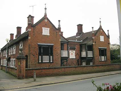
J.M. Clark – architect of The Custom House,
The Casino and Christ's Hospital School (now
demolished)
– used a 'plain Elizabethan style' in his plans drawn up in 1844 for
the Tooley and Smart Almshouses; there have been alterations and
additions in the since.
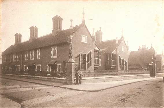 1884
1884
The above 1884 view of the
same corner was
taken by noted local photographer, William Vick. It comes from the
Ipswich
Society Image Archive (see Links).
In the 1860s William Vick an ex-teacher, now a photographer, had his
studio in London Road just where it meets Clarkson Street (Barrack
Corner) and was offering to take landscapes, residences and groups as
well as portraits.
TooleyStreet (today bearing the street nameplate 'Blackfriars Court')
is to the left and Foundation Street to the right, sloping towards the
docks; the horse manure
indicates the car-free era. Note the strip of granite setts linking the
pavements which gives the pedestrian mud and muck-free footwear when
crossing the dirt road (highlighted by Muriel Clegg in The way we went, see Reading list).
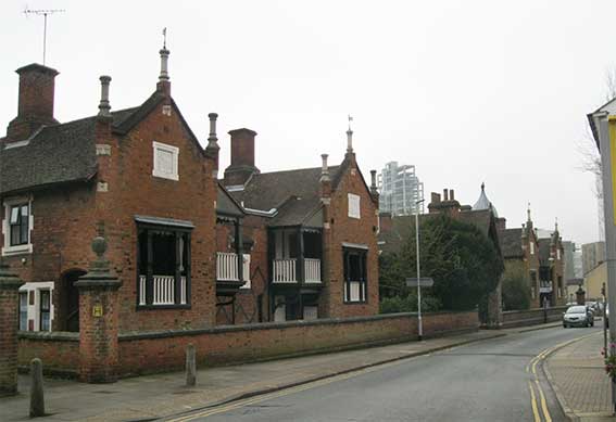 2017
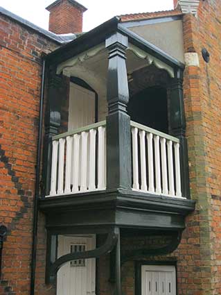
The differences between the 1884 and 2017 photographs
are interesting. The elaborate metalwork lamp on the square section
pillar has been replaced by a ball finial on a hexagonal section brick
pillar. The iron railings, used extensively here have been removed,
probably during World War II in a 'scrap for munitions' drive – the
cemented-over seatings of the railings can still be seen on the stone
wall copings. The roof ridge decorations have been removed. Most
strikingly, the gable-ends have been remodelled so that only the
central timber 'balcony' sections remain; also some of the tiled
canopies and doors on the Tooley Street elevation have been removed.
2017
The differences between the 1884 and 2017 photographs
are interesting. The elaborate metalwork lamp on the square section
pillar has been replaced by a ball finial on a hexagonal section brick
pillar. The iron railings, used extensively here have been removed,
probably during World War II in a 'scrap for munitions' drive – the
cemented-over seatings of the railings can still be seen on the stone
wall copings. The roof ridge decorations have been removed. Most
strikingly, the gable-ends have been remodelled so that only the
central timber 'balcony' sections remain; also some of the tiled
canopies and doors on the Tooley Street elevation have been removed.
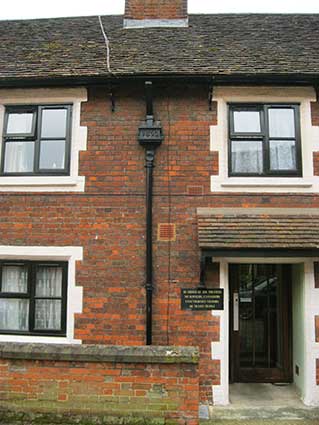
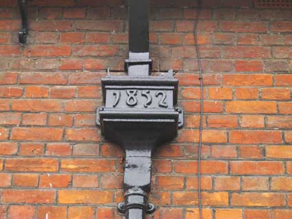
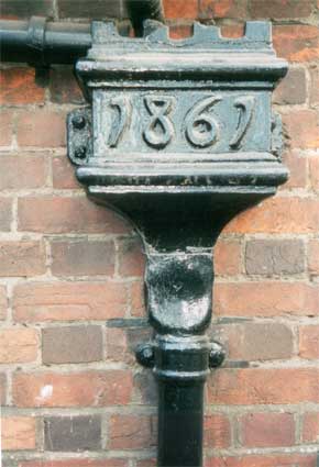
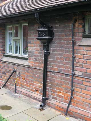
The dated rain-hoppers
[UPDATE
March 2017: Talking of the 'Tooley Street' elevation, we found a
rain-hopper (and not the only one) with an earlier date than others
recorded heretofore. '1852' indicates that the outer parts
of the almhouses were probably built nine years earlier than the
central gatehouse and courtyard (shown below).]
 2017 images
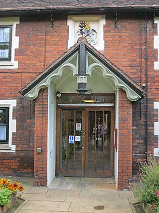
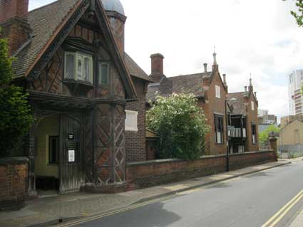
The gatehouse
Below: the gatehouse and inner courtyard (across the road
is a blue plaque celebrating Thomas
Gainsborough). The cast
'1861' characters in the rain-hopper (above the white van
in the photograph below left) resembles the carved date on number 6 St Helens Street. Other
dated rain-hoppers can be seen on our Dated
rainhoppers page.
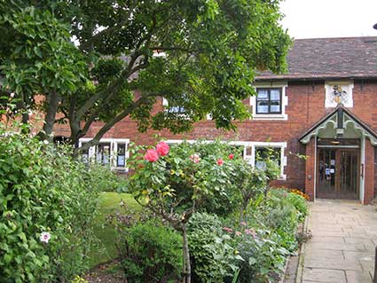
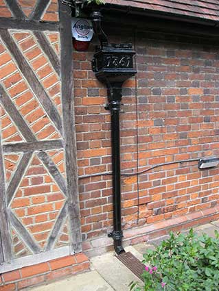
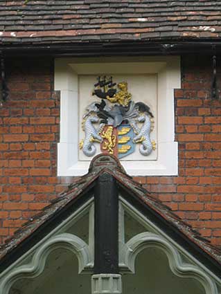
The gardens
[UPDATE
September 2015:
On Heritage Open Day weekend we were able to walk into the sheltered
garden within the almshouses. These photographs record that visit and
show that the internal rainhoppers also carry the date '1861'. We also
note another rather fine coloured, relief rendition of the Ipswich Borough coat of arms. The informative
plaques within the porch tell their own story.]
 2015 images
'THESE
GARDENS WERE BEAUTIFIED IN
1952 IN MEMORY OF WILLIAM S. JEWHURST
FOR 28 YEARS HON. SECRETARY TO THE
IPSWICH AND EAST OF ENGLAND
HORTICULTURAL SOCIETY.
– A LOVER OF GARDENS –'
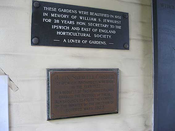
'
JOHN
SHEWELL
CORDER,
O
F I
PSWICH, A
RCHITECT, WHO DIED
IN THE Y
EAR 1922,
BY A BEQUEST OF T
WO H
UNDRED P
OUNDS
ENABLED THE T
RUSTEES OF THESE
A
LMSHOUSES TO ADD TO THE COMFORT
OF THE I
NMATES BY THE ERECTION OF
COVERED WAYS, 1923.'
John Shewell Corder was an
interesting architect of his day, working on many buildings in Ipswich
and beyond. A favourite is the Art Nouveau ‘Scarborow’
shop in Dial Lane (now Pickwick’s Tea Shop). He was responsible for a
large number of Ipswich buildings and country houses beyond. He was
also a talented
illustrator and recorded many buildings and corner-posts before they
were demolished – and some of which still stand.
Beautifully maintained lettering plaques in gold,
red and black
paint
on the relief moulding celebrate these ancient endowments to the town
by
two (or more) of its wealthiest sixteenth century merchant
philanthropists – although the actual buildings are more recent
replacements.
 2003 images
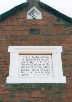
Reading from the upper (town end) of Foundation Street:-
'Henry
Tooley portman
of Ipswich by his will
dated Nov. 15 1550
left
several
estates for the
purpose of erecting Alms
houses and for the main
finance
of poor persons
therein'
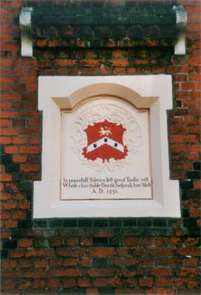
'In
powerfull Silence lett great Toolie rest
Whose charitable Deeds bespeak him blest
A.D. 1551'

'The Almshouses
were founded in the year
1550 and
rebuilt in
the year
1846
on
and near the site of the
original edifice'
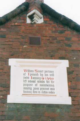
and imperceptibly on to Smart's Almhouses:
'William
Smart portman
of Ipswich by his will
dated January 9 1598
left
several estates for the
purpose of maintaining
sundry poor persons and
funding
them in clothes, coals &c'
 2004 images
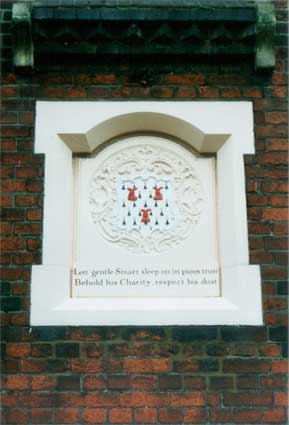
'Let gentle Smart
sleep on in pious trust
Behold his Charity, respect his dust'
And much more recently - and in slightly more municipal lettering high
on
the last gable:-
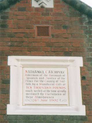
'NATHANIEL
CATCHPOLE
Alderman of the Borough of
Ipswich and Justice of
the
Peace for the County of Suf-
folk by a Munificent Gift of
TEN THOUSAND
POUNDS
much needed at the time greatly
increased the Usefulness of
these
Almshouses
– 26th June 1902'
–
And finally (with an individual use of full-stops) a
roll-call of
well-known
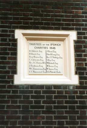
Ipswich and Suffolk names on a plaque near the main entrance:-
'TRUSTEES OF
THE IPSWICH
CHARITIES 1846
H. Aldrich. Esq.
H. Bond. Esq.
Benjn. Beame. Esq.
C. Colchester. Esq.
Rev. J.C. Ebden M.A.
J. Footman. Esq.
W.C. Fonnereau. Esq.
C.C. Hammond. Esq.
J. Head. Esq.
Peter B. Long. Esq.
Rev. J.C. Nottidge. Esq.
S. Ray. Esq.
W. Rodwell. Esq.
M. Turner. Esq.
W. Turner. Esq.
S.A. Nottcutt. Clerk.'
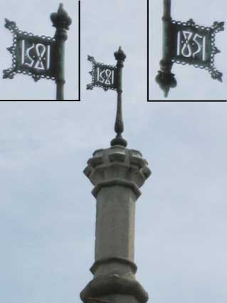
The metalwork pennants
It was only in 2014 that we noticed
small
decorative 'vanes' (similar to weather vanes, but it doesn't look as if
they move) above chimney-like, stonework masts (our term).
1.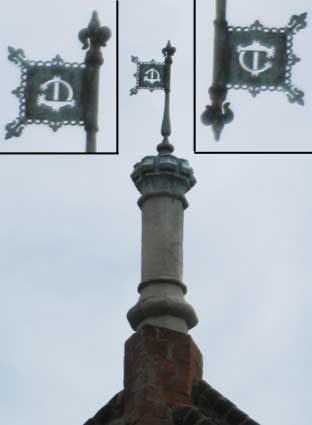 2.
2.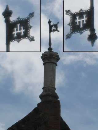 2014 images
1. From the north end of the Foundation
Street frontage we see a
monogram which appears to be upside down (see the date, later); it
could be 'TC' for Tooley Court. The close-up to the upper right shows a
proposed solution.
2. The next one down the street looks like
a freemasonry symbol (see
the Tau cross in the circle on the Freemason's
Hall), but turning that one upside down also produces a convincing
'HT' monogramme for Henry Tooley.
Moving down past the main entrance to
Tooley Court are the next
pair of vanes.
3. This date is definitely upside down (a
fact which gave us the idea
to flip the first two) and clearly reads '1851' in the upper right
close-up.
4. The final monogramme appeared at first
to be the
right way up: intertwining
'M' and 'S' suggesting the foundation's connection with St Mary-at-Quay at the bottom of the
road – indeed a similar sort of monogram in wrought iron can be seen
above that church's gates. However, mature reflection leads us to
believe that this, too, is upside down. Surely it commemorates the
second merchant benefactor of the Tooley's and Smart's Almshouses: William Smart (the monogram being 'WS').
3. 4.
4.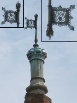
The final photograph in the sequence shows
vane number 4 (upper
left) and the almshouses at the corner with Smart
Street.
See our rain-hoppers page for
dated weather vanes in the town.
Maritime Ipswich plaque
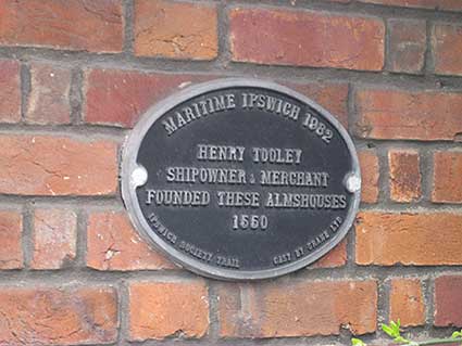
'MARITIME IPSWICH
1982
HENRY TOOLEY
SHIPOWNER & MERCHANT
FOUNDED THESE ALMSHOUSES
1550
IPSWICH SOCIETY TRAIL CAST BY
CRANE LTD'
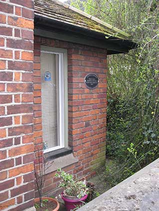
Tucked away south of the main
entrance to the courtyard, this plaque can be found; it is sometimes
obscured by foliage.
See our plaques page for the
full set of ten Ipswich Society Maritime Ipswich
1982 plaques.
The Tooley brass
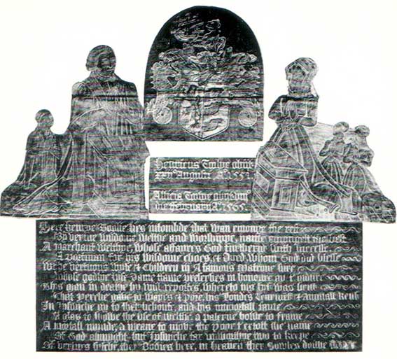
Above: the brass memorial to Henry Tooley (?-1551), his wife
Alice and their children features a version of the Borough coat of arms at top, centre. The
memorial was once at St Mary-At-Quay Church,
but is now part of the Ipswich Museum
collections. None of their children, two daughters and one son, appear
to have survived adolescence. Tooley's wife, Alice née Purpet (see the Street name derivation of Purplett Street)
who survived him, was a remarkable woman in her own right.
Reading
'Great Tooley of Ipswich' by John Webb. Boydell
Press, first
published 1970 (Suffolk Records Society). ISBN-13: 9780900716102
When Henry Tooley drew up his will shortly before his
death in 1551 he
ensured the survival of two monuments to his career as a merchant in
Ipswich: the almshouses which still stand in the town, and an account
book which the Corporation originally acquired to administer his
bequest and now hold in their archives. From this rare and valuable
record, augmented by a few family and business letters and a thorough
search of local and national archives the author has written a brief
but impressive biography. A major consideration throughout this
biography has been to place the subject in the social and economic
framework of his time. This aim is followed most effectively, not only
in the chapters on overseas and internal trade but also in the account
of his participation in town government. Great Tooley is thus more than
a simple biography; it presents, with meticulous scholarship, an
illuminating picture of wider problems and developments in the early
Tudor period.
See also our More
almshouses page. Further almshouse lettering can be
found in Colchester.
Richard
Felaw's House
As a footnote, glance across Foundation Street at the
multi-storey car park and imagine yourself there in the early 1960s
looking at the
houses (pictured below) parts of which survived from the 15th century.
They
belonged to the noted merchant, Portman, Ipswich Bailiff and MP,
Richard Felaw (see Street name derivations
and Felaw Street). He
bequeathed the houses to the nascent Ipswich Grammar School, endowing
it with lands at Whitton so that children of needy parents could
attend without paying fees. These new premises made it possible for the
school (now The Ipswich School) to take boarders, which it has
continued to do to this day. One of the first pupils to
benefit from Felaw’s endowment was
Thomas Wolsey, later Cardinal Archbishop
of York and Lord Chancellor of
England. In 1528, when at the height of his power, he created the
Cardinal’s College of Mary in Ipswich,
incorporating the School in the
foundation. He envisaged an institution of the same splendour as Eton
or Winchester, but the college was only half built when he fell from
power in 1530. The endowments were forfeited to the King and only one
of the gateways of the college now survives, next to St Peter’s Church
in the dock area.
1960s photographs
 c.1963
Photographs courtesy The Ipswich Society
Image Archive (see Links).
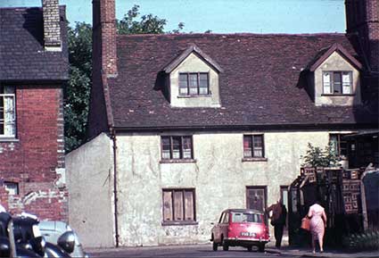 Early 1960s; comparison photo below.
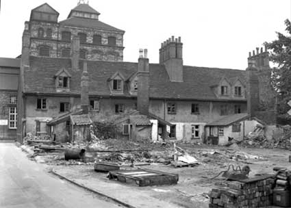
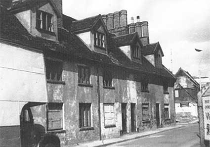
Above: Richard Felaw’s House in Foundation
Street shortly before demolition c.1963. The second photograph shows
the the southern part of the buildings
seen from School Street. The redbrick building at the left stands on
the east side of Foundation Street. All buildings here have gone. The
stacked wooden beer crates at the right were in the yard of the Unicorn
Brewery and just behind the photographer to the right would have stood
the school which gave the street its name: Christ's Hospital School. The
school moved to Wherstead Road in 1841. The significance of the School
Street photograph is that the remnants of the church of Blackfriars
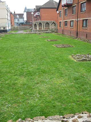
Priory, which were first discovered by archaeologist Nina Frances
Layard in 1898, were fully uncovered here beside the south walls of
the
Unicorn Brewery and the footway Blackfriars Walk created so that the
public can engage with the historic site: the only in situ monastic remains in Ipswich
– which, of course, had a number of monasteries.
The presence of the legend 'F.W.' – presumably 'Foot Way' – on the map
(below) indicates that
part, at least, of this pathway existed in 1902, emerging beside Martin & Newby's premises in Fore
Street.
Comparison photographs (2016)
 <1
<1 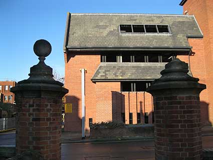 <2
<2
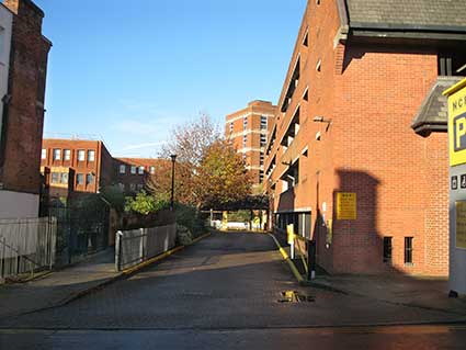
Above: sequence of 2016 photographs of the Foundation Street frontage
of the
NCP car park. 1. Rosemary Lane, now a narrow pathway, at
far left; the driveway down to the car park entrance barriers,
following the line of the proposed Ring-Road
dual carriageway in the
1960s. 2. Moving northwards, the view from behind two
entrance piers to Blackfriars Court, one with a missing ball finial.
Below: 3. The view roughly equivalent to the c. 1963
photograph from School Street (above). 4. The exit from the
car park with Wingfield Street curving round it to the right.
 <3
<3 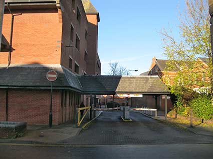 <4
<4
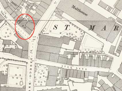
1902 map
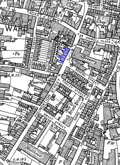 1902 map
We see "Richard Felaw's House" (coloured blue here) fronting Foundation
Street
running south from the corner with Little Wingfield Street. Today's
street layout is very different:-
1. The NCP multi-storey car park covers the footprint of the houses and
more. Richard Felaw's House – the late Dr John Blatchly points out that
only part of the building dated back to the 15th century – was
tragically demolished in the early 1960s to make way for the planned
dual
carriageway Ring-Road which would have ploughed through many historic
buildings to carry traffic from today's Cromwell Square (once a dual
carriageway taking traffic from Civic Drive) round to Bond Street and
Crown Street, and on to St Matthews Street – part of which is still a
dual carriageway. The Ring-Road was mercifully never completed. It was
not until the 1980s that the car park block was built.
2. Little Wingfield Street has disappeared but the east-west section is
renamed Wingfield Street and extends to the north-south Wingfield
Street
as shown on the 1902 map. The NCP car park covers and distorts the
southern part of this street so that it is little more than a footpath,
as is the eastern part of Rosemary Lane
which has been narrowed to a footpath and routed round the footprint of
the car park.
3. School Street, as described above, and Tooley Street with the
close-packed housing between them have all disappeared to be replaced
by a sheltered housing complex, Blackfriars Court which extends
eastwards to Lower Orwell Street. The thoroughfare, Blackfriars Court,
is on the site of Tooley Street as shown on the map. Today the
almshouses are bounded by Foundation Street, Smart
Street, Shire Hall Yard and Blackfriars Court.
 <Kindred
Spirit photo
<Kindred
Spirit photo 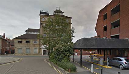
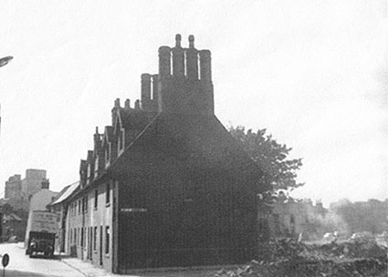
Above left: this remarkable photograph comes from David Kindred's Kindred Spirit collection. We see
the rear of the Richard Felaw House, looking eastwards from Little
Wingfield Street in 1963, just before full demolition.
In the background is the Unicorn Brewery.
The comparison with the modern version of the same view shows the exact
relative position of these buildings.
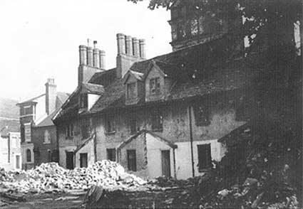
[UPDATE 11.4.2019: These three
photographs from the collection of Nick Wiggin were taken a little
later in the demolition of Richard Felaw's house than the one above. On
Foundation Street a parked 1960s box-van is in the foreground (also
visible in the second photograph) and the facade looks reasonably
normal. The second photograph from further north on Foundation Street
shows the view down towards the docks with the large silos in evidence;
rubble is in the right foreground with evidence of burning of timbers. The
third photograph (below) shows the Unicorn Hotel in the left
background; the Unicorn tower brewery rises above the roofline behind
the foliage. The outhouses have been demolished.]
 Photographs
courtesy Nick Wiggin
Photographs
courtesy Nick Wiggin
Dr John Blatchly points out in his book A Famous Antient Seed-plot of Learning
(see Reading list) that investigations prior
to the demolition of the house of Richard Felaw (c.1420-1483) revealed
that
only a small portion of the building dated back to the 15th century. It
is hardly surprising that such an old building should be altered
structurally and internally many times over such a long period.
However, the symbolic significance of the house in the story of Ipswich
School and of Thomas Wolsey in particular means, one
hopes, that the decision on the fate of the house would probably be
different in the 21st century.
See also our page on Wolsey's
College.
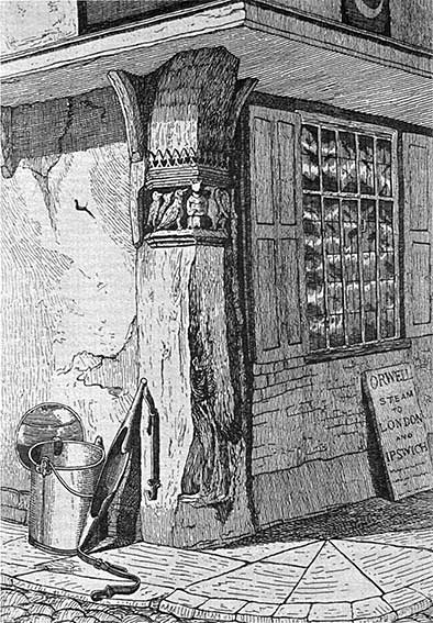
The Half-Moon Inn (Henry
Tooley's house?)
 1845
1845
The engraving
above is from Frederick
Russel and Wat Hargreen's Picturesque
Antiquities of Ipswich (published in Ipswich, 1845).
Half Moon
corner, Foundation Street/Lower Brook Street. Although the
building holding this fine post has been destroyed, the post itself was
saved and was eventually to be displayed at Christchurch Mansion. The
carvings depicting the old fable of the ‘fox and the geese’ were
originally designed as a satire on monastic orders. The Half Moon has
also been listed at 'Lower Foundation Street' and Lower Brook Street.
The illustration above indicates a timber-framed and plastered building
with a jettied first storey.
This was one of Ipswich's most ancient inns; one of only 24 listed in a
town assessment of 1689. It was demolished in 1960, a casualty of so
much widespread demolition in Ipswich which also swept away Holywells
Mansion (see following). This was possibly once the family residence of
Henry Tooley, a Portman of Ipswich and benefactor of the Tooley
Almshouses who died in 1551. Wood panelling and
mantelpieces from the inn were later removed to Holywells mansion, built by the Cobbold
family. The corner post is preserved in Ipswich Museums' store and went
on display as part of the Wolsey's
Angels exhibition in Christchurch Mansion in 2017-18. The inn
can also be seen under '1902 map' (above) of Foundation Street: at the
very bottom-left marked 'P.H.'.
For comparative maps of Foundation Street (1778,
1867 and c.1881) see our Courts and yards
page.
Home
Please email any comments and contributions by clicking here.
Search Ipswich
Historic Lettering
©2004 Copyright
throughout the Ipswich
Historic Lettering site: Borin Van Loon
No reproduction of text or images without express
written permission