 2015 image
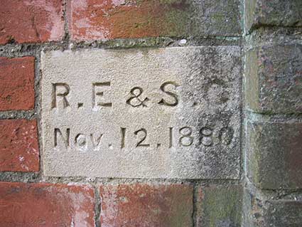
Nov. 12. 1880'
This very specific date is
unusual to be set in stone on a house,
although a single day does also appear on Primrose
Terrace plaque in Ranelagh Road. And do the initials refer to a
company, or individuals who first lived in the house, or the builder?
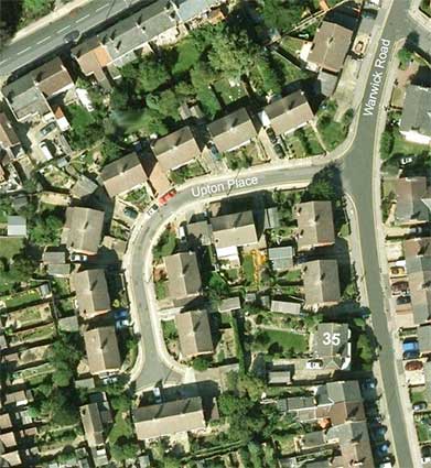
Below: the 1867 detail turned red and overlaid over the current aerial view – not an exact fit, but close enough.
 1867 detail
 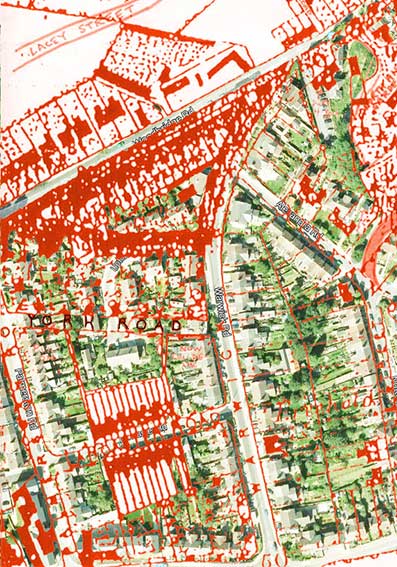 Comparison
It seems most likely that the angle of no. 35 was determined by the angle at which the now-disappeared York Road entered Warwick Road. (Incidentally, the present occupant points out that north of no. 35, the next house is numbered 39; see his update at the bottom of this page.)
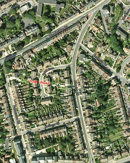
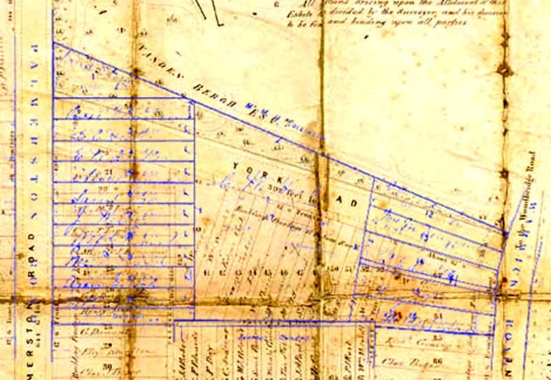
Taking the angle from no. 35 Warwick Road and drawing it back westwards to the 1970s houses (nos. 48-50), which are set back from the Victorian building line in Palmerston Road, shown as a pale line on the aerial view, seems to confirms this theory. The building on the east corner of Palmerston Road is 170 Woodbridge Road, marked on maps here as 'Rhynwick Lodge', but Bettley: Suffolk- East Pevsner (see Reading List) lists it as a red and white brick Italianate villa, 'The Casino', built for himself by the architect of the Custom House on the Wet Dock, J.M. Clark, in 1845-6 (scroll down for information). It seems that the actions of a later owner of the garden of The Casino, A. S. Vanden Bergh, had an important effect on the developement of housing to the south – see the F.L.S. maps below.
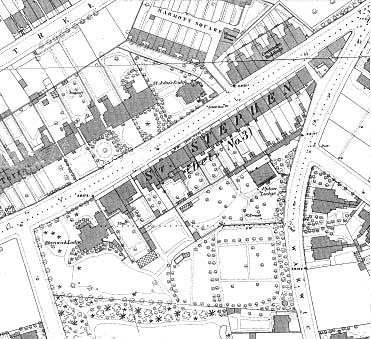 1883 detail
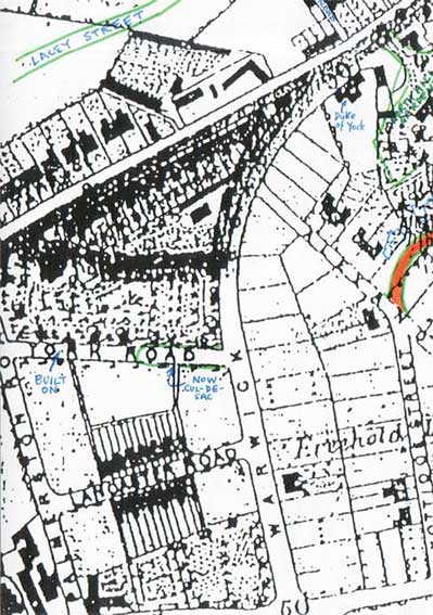
By the 1883 map (above) 'York Road' is not shown, but a boundary between Palmerston and Warwick Roads follows the same (or similar) line down to No. 35. Upton Lodge can be seen, angled parallel to Woodbridge Road, north of No. 35. York Road was planned, but never actually built.
The Freehold Land Society's role
Some welcome input from the Ipswich Building Society (formerly F.L.S.) archivist, Margaret Hancock:
'Yes you're right about FLS connection with York Road (the one off Warwick Road!) It's shown on the 1866 FLS St Helens Estate Plan (Ref: GF419/FLS/3/2/2/2).
There are also at least 2 bundles of deeds etc at RO relating to FLS purchase of St Helen's land (Refs: GF419/FLS1849/3/2/2 & GF419/FLS1849/3/2/101). If my memory serves me correctly one of these includes some correspondence with other owners of land/houses on the Woodbridge Road side of the estate who were not keen to see York Road developed in the same way as Lancaster Road on the south side of the FLS plot. I think the name Vanden Bergh comes up somewhere.'
'We are pleased to provide the attached image of our 1866 plan as requested and would be happy for you to use it on your website if you wish.
Apologies for the poor quality image which is largely due to damage to the original plan. [Interesting that the name given to today's Warwick Road on the plan is 'Water Lane', suggesting that the springs in Albion Hill fed flows of water down to Spring Road towards Major's Corner, via The Wash to the river.]
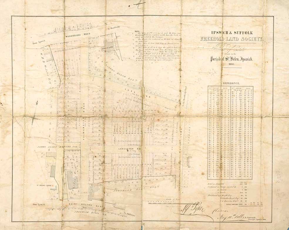 1866 map
I’ve also attached our Palmerston Road Estate 1880 (GF419/FLS1849/3/1/1/37) in case this is also relevant to your investigations into 35 Warwick Road. [We had hoped that the name of the F.L.S. ballot-winner to occupy – or sell on – the plot(s) on Warwick Road might match the initials on the plaque on number 35; although difficult to read, nothing seems to match.]
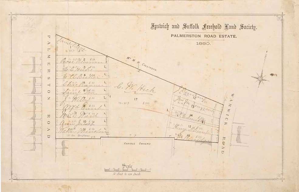 1880 map
And finally, on checking the Freehold Land Society database I’ve found the reference that I vaguely remembered. This is in an Abstract of Title to freehold land in St Helens 1865 – 1878 (Ref: GF419/FLS1849/3/2/259)
The following extracted description may be of interest – “All those three plots of land & heredits together with rights over roads & passages Except the road called York Road and the two passages leading therefrom from which Road & passages were sometime since purchased by A S Vandenbergh & closed” (1872).'
We are very grateful to the Ipswich Building Society for permission to include these conclusive maps.
Placing the 1880 detail ('The Palmerston Road Estate' – in blue) over the 'St Helens Estate' plan shows a number of variations in the perimeter of this modestly-sized plot. However, the angle at the passageway between plots 14 and 15 (in blue, which can still be seen as the driveway of number 35) matches that of the proposed York Road. It would appear that in 1880 additional plots (12 and 13) were planned. It is possible that 13 and 14 were purchased and no. 35 Warwick Road built on them, as the house is bigger. The central area (F.L.S. ballot-winner, C.W. Hick) remained undeveloped until Upton Place was built, probably in the 1960s.
 1880 over
1866 maps
1880 over
1866 maps
Occupants
Time for some research into the occupants of number 35...
‘RE & SC, Nov. 12. 1880’ at 35 Warwick Road
White’s Suffolk Directory 1855
35 Warwick Road - Gower, Thos. Foote (soap manufacturers)
no number - Weetman, Mrs Mary Tollemache [this would be Upton Lodge' in the same orientation as today's 2-4 Upton Place, but slightly to the north of it.]
- Woodbridge Road -
[NOTE: in White’s Suffolk Directory 1855, entry for -SOAP MANUFACTURERS -
Gower & Hunt, Friars Road
also, ‘York Road’ not listed.]
Stevens Directory of Ipswich 1881
No numbers after 1-4 [this suggests that these four small terraced cottages close to the Spring Road junction on the west side were initially numbered 1-4, the numeration being divided odds/evens at a later date], but from Lancaster Road northwards:
Dennis, C.C.
Frier, W., coal merchant. Derwent House
Furlong, Thos., Magdalla Villa
Durrell, Joseph, Magdalla Villa
Gower, T.F.
Clements, Thomas, Talmash
Upton Lodge
- Woodbridge Road -
Stevens Directory of Ipswich 1885
As above, but with
Weetman, Mrs, Upton Lodge
Stevens Directory of Ipswich 1894
35 Warwick Road - Gower, Thomas Foote, Chestnut House
Kelly’s Directory of Ipswich 1906
35 Warwick Road - Gower, Thos. Foote
Simmonds, Frank, hairdresser
Kelly’s Directory of Ipswich 1909
35 Warwick Road - Gower, Thomas Foote
Bantoft, Guy Cyril, Upton Lodge
Simmonds, Frank, hairdresser
Kelly’s 1910
As above
Kelly’s 1912
As above, but
Culf, H.B., hairdresser replaces Simmonds, Frank
Kelly’s 1913
As above, but
Culf, H.B., hairdresser is at number 53
[NOTE: number 53 is the address of the lower/corner building which, up to the 1980s, was the premises of Capelli hair designs; they moved round into larger premises at no. 206 Woodbridge Road – still there in 2015.]
Kelly’s 1914
As above
Kelly’s 1915
As above
Wartime bomb damage?
There is a story that bomb damage during World War II wiped out several houses around today's Upton Place, hence the need for the modern infills. One piece of evidence which may support this is that there is no number 37 in the street. In the book Ipswich: the war years (see Reading list), Cyril Garnham of Harkstead recalls:
"I lived in Harmony Square until 1943 with my parents and two brothers, Peter and Arthur. Enemy aircraft were frequently over the town and broken nights sleep were a feature of daily life. On the night of August 25, 1942 the raiders were met by particularly heavy anti-aircraft fire which almost certainly forced one of the planes to drop two 500kg high explosive bombs. The first of these fell in the wooded grounds of Derby Lodge [shown in green on the 1883 map on our Belle Vue Road page and the site of today's North Hill Gardens], next to the Duke of York public house at the junction of Woodbridge Road and Warwick Road. The bomb failed to explode and was removed from beneath a beech tree by a bomb disposal unit some five days later.
The second bomb punctured the rear roof of the nearby Mission Rooms [in Harmony Square] and passed through the building and out through the ground floor window, where it buried itself in the soft earth.At the time, my parents, my brother and I, together with an elderly neighbour, were bundled together in a Morrison shelter , which occupied almost the whole of the front room!
After waiting for the debris and dust to settle and on the assumption that the bomb had exploded we ventured out, together with the neighbours, to provide any assistance necessary to the occupants of the Mission Rooms.
To our amazement an elderly couple – a Boer War veteran and a lady who was deaf and dumb, were sleeping downstairs, had a miraculous escape and were unhurt. The bomb must have passed immediately over them. Having found out that there was nobody injured, neighbours returned to their homes only to be only to be advised by the police and air raid wardens to evacuate our homes shortly afterwards, we had been standing on an unexploded bomb!
We were taken to a large house on Woodbridge Road prior to being taken by bus to Holywells Park mansion, which was used as a rest centre. We stayed the night and the next day found temporary accomodation with friends. Eventually on August 30 we returned home and I recall the defused bomb being rolled away before being taken away in a lorry for disposal. Fortunately the bomb had caused no casualties and limited damage to property – several houses had previously been been damaged when the mine exploded in Cemetery Road in September 1940.
Tragically on the same night as the above incident, a house at the junction of Nacton Road and Lindbergh Road was demolished by a bomb that killed a mother and eight children – such is the luck of the draw in wartime!
The 'square' consisted of two mews of small terraced houses standing opposite each other and separated by thin front gardens and an unmade area, used by children as a play area. At one end of the square stood a large building occupied by Whitfield King Stamp Company which had access from Lacey Street and at the other end and backing on to the houses on Woodbridge Road stood the Mission Rooms – a two-storey building providing accomodation for the elderly. Harmony Square no longer exists – it was demolished in the late 1950s and is now the site of old people's accomodation, Hanover Court."
Parsonage?
Another story is that in 1880 no. 35 was built as a parsonage for St Helen's Church. However, we see from the map on our Palmerston Road page that a large house labelled clearly 'Rectory' once stood north of St Helen's Church, fronting Woodbridge Road – the space which is now the entrance to St Helen's Primary School. Presumably, the church would not have needed a parsonage. In addition, a rectory is used for administrative purposes (often also as lodgings for visiting church officials) and is traditionally built close to the church to which it is associated. See the point 1 in the Update below.
Our money was on the characters on the tablet: ‘R.E. & S.C. / Nov. 12. 1880’ being the 'signature' of the house's builders, but the following update presents a persuasive alternative explanantion...
[UPDATE 4.12.2016: "Hello Borin, Thank you for the note you popped through the door. And for the research work you’ve done on your website. I have a couple of snippets of info which might be helpful.
1. 35 did used to be a parsonage. St Edmundsbury Diocese. But they bought no 35 in 1982, so it was not a purpose built parsonage / rectory. But it has been a parsonage for a short while.
2. The names on the stone, “RE and SC”: I have a theory. I think they actually say “RE & SG” but the stonework has become indistinct over time. Why? In 1880 the land no. 35 stands upon was sold as a plot, implying any previous building was pulled down by then. It was sold to a Richard E Gower. If he had a wife / son / other family member then this would make sense: If I paid to have a house built, I’d want my name on the plaque.
I’ve also heard a theory about the missing no. 37: Originally the plot was going to have two houses built upon it. The numbering of neighbouring houses took this plan into account. Then the plan changed and a bigger single house was built.
I hope these snippets help you. Jeremy Foster"
Many thanks to Jeremy for his additions/correction; the initials for Gower seem to match the occupant listed above (Thomas Foote Gower, soap manufacturer) – perhaps he was the son of Richard E. Gower, mentioned by Jeremy. We had wonderd if the erosion of the stone plaque might have made a 'G' look like a 'C'.]
The Casino (once 'Rhynwick Lodge'), 170 Woodbridge Road
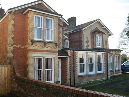
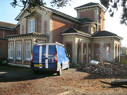 2018 images
The house, now divided into flats during clearance of the car park and possible interior works in 2018. Around 1980 it acted as the headquarters of St John Ambulance.
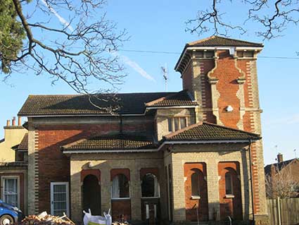
"The Casino, a hitherto unsuspected work by [John Medland] Clark, designed, built and used by him as his residence in 1845 and 1846, still exists today, now known as 170 Woodbridge Road, standing as then 'on an eminence ... within ten minutes walk of the centre of the flourishing and rapidly increasing town of Ipswich’. The 'unrivalled views of the picturesque Orwell' which it had then, have unfortunately been obscured. Correlation of evidence from many sources leads us through its change of name from The Casino, to James Cottage, to Rhynwick Lodge, to plain 170 Woodbridge Road, and though some structural alterations and additions have been made in the intervening years, it is still very much the house that Clark designed —the polychromy of white and red brick, the Tuscan style of overhanging eaves, used to such effect on the Custom House, the turret, reflecting the campanile on that same building."
[Source: John Medland Clark 1813-1849 'Sometime Architect of Ipswich' by Ruth Serjeant, The Suffolk Institute of Archaeology and History reserch paper. Volume XXXVII, part 3 (1991)]
Below: the 1867 detail turned red and overlaid over the current aerial view – not an exact fit, but close enough.
1867 detail ComparisonIt seems most likely that the angle of no. 35 was determined by the angle at which the now-disappeared York Road entered Warwick Road. (Incidentally, the present occupant points out that north of no. 35, the next house is numbered 39; see his update at the bottom of this page.)
Taking the angle from no. 35 Warwick Road and drawing it back westwards to the 1970s houses (nos. 48-50), which are set back from the Victorian building line in Palmerston Road, shown as a pale line on the aerial view, seems to confirms this theory. The building on the east corner of Palmerston Road is 170 Woodbridge Road, marked on maps here as 'Rhynwick Lodge', but Bettley: Suffolk- East Pevsner (see Reading List) lists it as a red and white brick Italianate villa, 'The Casino', built for himself by the architect of the Custom House on the Wet Dock, J.M. Clark, in 1845-6 (scroll down for information). It seems that the actions of a later owner of the garden of The Casino, A. S. Vanden Bergh, had an important effect on the developement of housing to the south – see the F.L.S. maps below.
1883 detailBy the 1883 map (above) 'York Road' is not shown, but a boundary between Palmerston and Warwick Roads follows the same (or similar) line down to No. 35. Upton Lodge can be seen, angled parallel to Woodbridge Road, north of No. 35. York Road was planned, but never actually built.
The Freehold Land Society's role
Some welcome input from the Ipswich Building Society (formerly F.L.S.) archivist, Margaret Hancock:
'Yes you're right about FLS connection with York Road (the one off Warwick Road!) It's shown on the 1866 FLS St Helens Estate Plan (Ref: GF419/FLS/3/2/2/2).
There are also at least 2 bundles of deeds etc at RO relating to FLS purchase of St Helen's land (Refs: GF419/FLS1849/3/2/2 & GF419/FLS1849/3/2/101). If my memory serves me correctly one of these includes some correspondence with other owners of land/houses on the Woodbridge Road side of the estate who were not keen to see York Road developed in the same way as Lancaster Road on the south side of the FLS plot. I think the name Vanden Bergh comes up somewhere.'
'We are pleased to provide the attached image of our 1866 plan as requested and would be happy for you to use it on your website if you wish.
Apologies for the poor quality image which is largely due to damage to the original plan. [Interesting that the name given to today's Warwick Road on the plan is 'Water Lane', suggesting that the springs in Albion Hill fed flows of water down to Spring Road towards Major's Corner, via The Wash to the river.]
1866 mapI’ve also attached our Palmerston Road Estate 1880 (GF419/FLS1849/3/1/1/37) in case this is also relevant to your investigations into 35 Warwick Road. [We had hoped that the name of the F.L.S. ballot-winner to occupy – or sell on – the plot(s) on Warwick Road might match the initials on the plaque on number 35; although difficult to read, nothing seems to match.]
1880 mapAnd finally, on checking the Freehold Land Society database I’ve found the reference that I vaguely remembered. This is in an Abstract of Title to freehold land in St Helens 1865 – 1878 (Ref: GF419/FLS1849/3/2/259)
The following extracted description may be of interest – “All those three plots of land & heredits together with rights over roads & passages Except the road called York Road and the two passages leading therefrom from which Road & passages were sometime since purchased by A S Vandenbergh & closed” (1872).'
We are very grateful to the Ipswich Building Society for permission to include these conclusive maps.
Placing the 1880 detail ('The Palmerston Road Estate' – in blue) over the 'St Helens Estate' plan shows a number of variations in the perimeter of this modestly-sized plot. However, the angle at the passageway between plots 14 and 15 (in blue, which can still be seen as the driveway of number 35) matches that of the proposed York Road. It would appear that in 1880 additional plots (12 and 13) were planned. It is possible that 13 and 14 were purchased and no. 35 Warwick Road built on them, as the house is bigger. The central area (F.L.S. ballot-winner, C.W. Hick) remained undeveloped until Upton Place was built, probably in the 1960s.
1880 over
1866 mapsOccupants
Time for some research into the occupants of number 35...
‘RE & SC, Nov. 12. 1880’ at 35 Warwick Road
White’s Suffolk Directory 1855
35 Warwick Road - Gower, Thos. Foote (soap manufacturers)
no number - Weetman, Mrs Mary Tollemache [this would be Upton Lodge' in the same orientation as today's 2-4 Upton Place, but slightly to the north of it.]
- Woodbridge Road -
[NOTE: in White’s Suffolk Directory 1855, entry for -SOAP MANUFACTURERS -
Gower & Hunt, Friars Road
also, ‘York Road’ not listed.]
Stevens Directory of Ipswich 1881
No numbers after 1-4 [this suggests that these four small terraced cottages close to the Spring Road junction on the west side were initially numbered 1-4, the numeration being divided odds/evens at a later date], but from Lancaster Road northwards:
Dennis, C.C.
Frier, W., coal merchant. Derwent House
Furlong, Thos., Magdalla Villa
Durrell, Joseph, Magdalla Villa
Gower, T.F.
Clements, Thomas, Talmash
Upton Lodge
- Woodbridge Road -
Stevens Directory of Ipswich 1885
As above, but with
Weetman, Mrs, Upton Lodge
Stevens Directory of Ipswich 1894
35 Warwick Road - Gower, Thomas Foote, Chestnut House
Kelly’s Directory of Ipswich 1906
35 Warwick Road - Gower, Thos. Foote
Simmonds, Frank, hairdresser
Kelly’s Directory of Ipswich 1909
35 Warwick Road - Gower, Thomas Foote
Bantoft, Guy Cyril, Upton Lodge
Simmonds, Frank, hairdresser
Kelly’s 1910
As above
Kelly’s 1912
As above, but
Culf, H.B., hairdresser replaces Simmonds, Frank
Kelly’s 1913
As above, but
Culf, H.B., hairdresser is at number 53
[NOTE: number 53 is the address of the lower/corner building which, up to the 1980s, was the premises of Capelli hair designs; they moved round into larger premises at no. 206 Woodbridge Road – still there in 2015.]
Kelly’s 1914
As above
Kelly’s 1915
As above
Wartime bomb damage?
There is a story that bomb damage during World War II wiped out several houses around today's Upton Place, hence the need for the modern infills. One piece of evidence which may support this is that there is no number 37 in the street. In the book Ipswich: the war years (see Reading list), Cyril Garnham of Harkstead recalls:
"I lived in Harmony Square until 1943 with my parents and two brothers, Peter and Arthur. Enemy aircraft were frequently over the town and broken nights sleep were a feature of daily life. On the night of August 25, 1942 the raiders were met by particularly heavy anti-aircraft fire which almost certainly forced one of the planes to drop two 500kg high explosive bombs. The first of these fell in the wooded grounds of Derby Lodge [shown in green on the 1883 map on our Belle Vue Road page and the site of today's North Hill Gardens], next to the Duke of York public house at the junction of Woodbridge Road and Warwick Road. The bomb failed to explode and was removed from beneath a beech tree by a bomb disposal unit some five days later.
The second bomb punctured the rear roof of the nearby Mission Rooms [in Harmony Square] and passed through the building and out through the ground floor window, where it buried itself in the soft earth.At the time, my parents, my brother and I, together with an elderly neighbour, were bundled together in a Morrison shelter , which occupied almost the whole of the front room!
After waiting for the debris and dust to settle and on the assumption that the bomb had exploded we ventured out, together with the neighbours, to provide any assistance necessary to the occupants of the Mission Rooms.
To our amazement an elderly couple – a Boer War veteran and a lady who was deaf and dumb, were sleeping downstairs, had a miraculous escape and were unhurt. The bomb must have passed immediately over them. Having found out that there was nobody injured, neighbours returned to their homes only to be only to be advised by the police and air raid wardens to evacuate our homes shortly afterwards, we had been standing on an unexploded bomb!
We were taken to a large house on Woodbridge Road prior to being taken by bus to Holywells Park mansion, which was used as a rest centre. We stayed the night and the next day found temporary accomodation with friends. Eventually on August 30 we returned home and I recall the defused bomb being rolled away before being taken away in a lorry for disposal. Fortunately the bomb had caused no casualties and limited damage to property – several houses had previously been been damaged when the mine exploded in Cemetery Road in September 1940.
Tragically on the same night as the above incident, a house at the junction of Nacton Road and Lindbergh Road was demolished by a bomb that killed a mother and eight children – such is the luck of the draw in wartime!
The 'square' consisted of two mews of small terraced houses standing opposite each other and separated by thin front gardens and an unmade area, used by children as a play area. At one end of the square stood a large building occupied by Whitfield King Stamp Company which had access from Lacey Street and at the other end and backing on to the houses on Woodbridge Road stood the Mission Rooms – a two-storey building providing accomodation for the elderly. Harmony Square no longer exists – it was demolished in the late 1950s and is now the site of old people's accomodation, Hanover Court."
Parsonage?
Another story is that in 1880 no. 35 was built as a parsonage for St Helen's Church. However, we see from the map on our Palmerston Road page that a large house labelled clearly 'Rectory' once stood north of St Helen's Church, fronting Woodbridge Road – the space which is now the entrance to St Helen's Primary School. Presumably, the church would not have needed a parsonage. In addition, a rectory is used for administrative purposes (often also as lodgings for visiting church officials) and is traditionally built close to the church to which it is associated. See the point 1 in the Update below.
Our money was on the characters on the tablet: ‘R.E. & S.C. / Nov. 12. 1880’ being the 'signature' of the house's builders, but the following update presents a persuasive alternative explanantion...
[UPDATE 4.12.2016: "Hello Borin, Thank you for the note you popped through the door. And for the research work you’ve done on your website. I have a couple of snippets of info which might be helpful.
1. 35 did used to be a parsonage. St Edmundsbury Diocese. But they bought no 35 in 1982, so it was not a purpose built parsonage / rectory. But it has been a parsonage for a short while.
2. The names on the stone, “RE and SC”: I have a theory. I think they actually say “RE & SG” but the stonework has become indistinct over time. Why? In 1880 the land no. 35 stands upon was sold as a plot, implying any previous building was pulled down by then. It was sold to a Richard E Gower. If he had a wife / son / other family member then this would make sense: If I paid to have a house built, I’d want my name on the plaque.
I’ve also heard a theory about the missing no. 37: Originally the plot was going to have two houses built upon it. The numbering of neighbouring houses took this plan into account. Then the plan changed and a bigger single house was built.
I hope these snippets help you. Jeremy Foster"
Many thanks to Jeremy for his additions/correction; the initials for Gower seem to match the occupant listed above (Thomas Foote Gower, soap manufacturer) – perhaps he was the son of Richard E. Gower, mentioned by Jeremy. We had wonderd if the erosion of the stone plaque might have made a 'G' look like a 'C'.]
The Casino (once 'Rhynwick Lodge'), 170 Woodbridge Road
2018 imagesThe house, now divided into flats during clearance of the car park and possible interior works in 2018. Around 1980 it acted as the headquarters of St John Ambulance.
"The Casino, a hitherto unsuspected work by [John Medland] Clark, designed, built and used by him as his residence in 1845 and 1846, still exists today, now known as 170 Woodbridge Road, standing as then 'on an eminence ... within ten minutes walk of the centre of the flourishing and rapidly increasing town of Ipswich’. The 'unrivalled views of the picturesque Orwell' which it had then, have unfortunately been obscured. Correlation of evidence from many sources leads us through its change of name from The Casino, to James Cottage, to Rhynwick Lodge, to plain 170 Woodbridge Road, and though some structural alterations and additions have been made in the intervening years, it is still very much the house that Clark designed —the polychromy of white and red brick, the Tuscan style of overhanging eaves, used to such effect on the Custom House, the turret, reflecting the campanile on that same building."
[Source: John Medland Clark 1813-1849 'Sometime Architect of Ipswich' by Ruth Serjeant, The Suffolk Institute of Archaeology and History reserch paper. Volume XXXVII, part 3 (1991)]
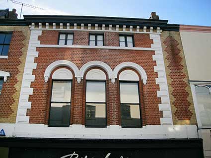 24 Tavern Street