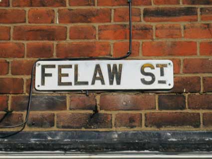
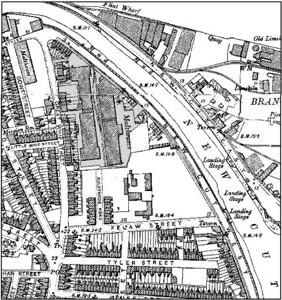
Felaw Street
Felaw Maltings, Maltings Terrace, Bulstrode Road, Great Whip
Street, Gower Street, Genesis, New Cut West tramway
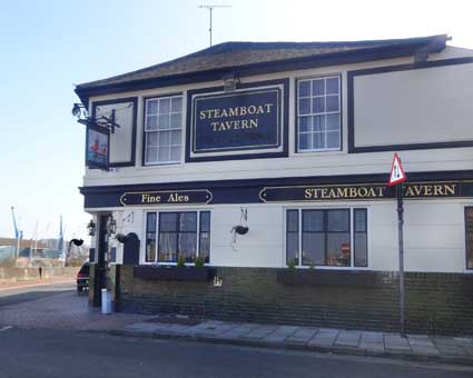
Steamboat Tavern, Stoke Quay
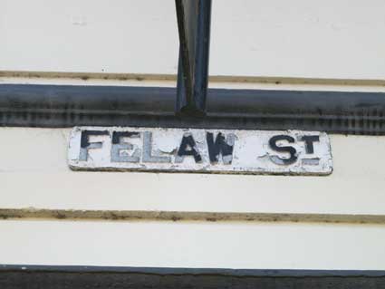
Named after a 15th century local merchant (see Street
name derivations) Felaw Street runs from The Steamboat Tavern – the
only building on that side of the road – and Felaw Maltings
up to the Coin Op laundrette on the corner with Great Whip Street. The
small street sign hiding beneath the Steamboat's hanging sign is
revealing.
 2014 images
The white paint on the sign is weathered and flaking and visible
beneath the main lettering is the attribution to the manufacturer.
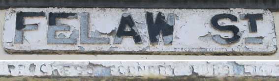
'FELAW
ST.
PROGRESS FOUNDRY BURSLEM'
It is curious to reflect
on the fact that a town full of ironfoundries saw fit to go all the way
to Burslem for its street signs. The town of Burslem, known as the
Mother Town, is one of the six towns that amalgamated to form the
current city of Stoke-on-Trent, Staffordshire. It looks as though a
storage company now inhabits The Former Progress Foundry, Leek New
Road, Stoke-on-Trent.
Tim Leggett, to whom our thanks, sends in a 'lost' piece of Tolly Cobbold lettering on the Felaw
Street Steamboat sign. Overpainting will eventually give way to
weathering and these bold caps with a drop shadow are so clear that
it's a surprise that we haven't noticed them before. The Steamboat
retains all of its Tolly-style livery, even though the brewery lost its
tied houses many years ago.
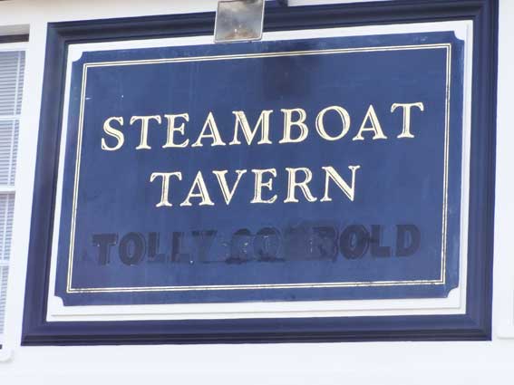 Photographs courtesy Tim Leggett
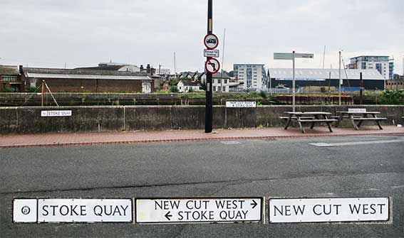
Felaw Street runs from the New Cut waterfront westwards to meet Vernon
Street. The street nameplates opposite The Steamboat Tavern are
instructive, not to mention numerous as shown in the photograph above.
Stoke Quay runs left from here all the way round to the junctions with Dock Street and Great Whip Street. Maps
often show the whole road as 'New Cut West'. However,
by these signs New Cut West runs to the right past Debbage Yachting and
the Griffin Wharf tramway (see bottom of this page) and down to the
corner with Bath Road – site of the long-demolished Griffin Inn. This
is close to the site of the 21st century tidal barrier at the mouth of
New Cut. New Cut
widens out close to this junction to enable the mooring of vessels.
This is
because the original west lock of the Wet Dock exited here and
our Wet Dock map page shows the unusual
shaping of the opposite bank where it was rebuilt after closure of the
lock, to be replaced by the southern lock we see today. Across
the waterway, on the Island site, New Cut East leads to the gables of the
Harbour Master's Office, with (partially obscured) the Lock-Keeper's
House).
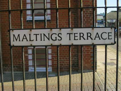
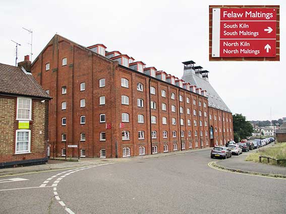
Maltings Terrace
and Felaw Maltings
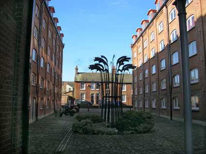
In the centre of the courtyard in the centre of Felaw Maltings is a
shaded sculpture: 'Barley' by Vanessa Parker. A colossal sheaf of
barley made from tubular steel rods telescoped to form 'stalks' and 5mm
steel plate for the 'heads' with steel rods for the 'ears'. They form
part of the refurbishment of the paving around the maltings and the
Ipswich Wet Dock, undertaken by Ipswich Borough, Ipswich Port and
English Heritage. Part of the Waterfront
Regeneration Project, the
sculpture recalls the former function of the heritage buildings on
either side which were originally devoted to converting barley into
malt. The maltings were built as a pair between 1904 and 1911, and
listed as Grade II in 1972 when still in use. When they closed in 1978,
they were the last floor maltings operating in Ipswich, all others
having closed or been replaced by the rather more brutalist 1960s-built
Wanderhaufen malting plants. In 1984 they were placed on the Ipswich
buildings-at-risk register.
In 1997 they were refurbished by new owners for a mixture of office and
residential use.
In the background is the tiny Maltings Terrace:
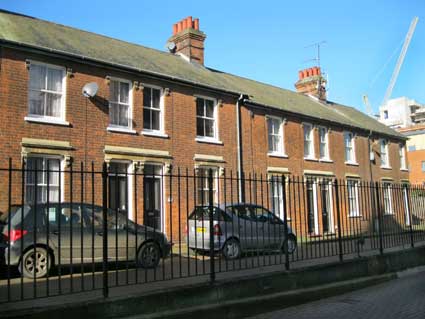
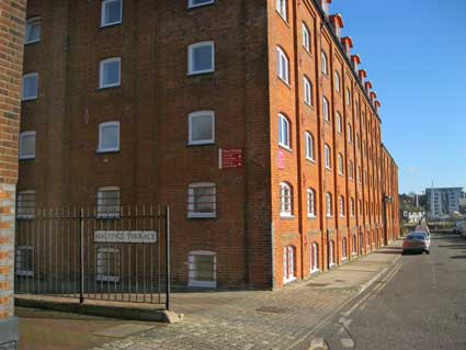
Above left: on the far left can be seen the edge of the lettered Paul's Tenement Trust buildings. Above
right: on the right through the railings can be seen The Steamboat
Tavern on the corner with New Cut West.
 2021 images
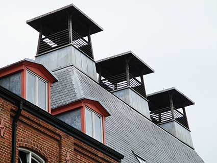
Above: Maltings Terrace at the left, with Felaw maltings, plus an
example of their signs which presreve the origins of the building. Also
a close-up of the reconstructed kiln vents.
For a view of Felaw Maltings, The Steamboat and Felaw Street from the
Island, see New Cut East.
One quotation we came across: 'Behind the two kilns stood a row of five
sturdy houses, known appropriately as Maltings Terrace. Two of these
were occupied by the Bates brothers, Ernie and Albie. The latter was a
flat cap and braces-type foreman, who I often encountered at Albion
Mill. I was transfixed by his habit of dipping his hand into the
nearest sack of grain, chewing thoughtfully on the contents and then
spitting out a stream of husks as he spoke.'
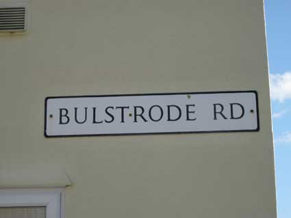
Bulstrode Road
Next is Bulstrode Road, a short street of terraced houses ending in
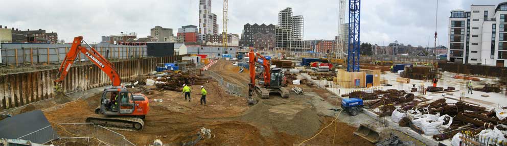
railings overlooking the site of a major building project in 2013.
Below: the Great Whip Street site on 18 April 2013, seen
from the far end of Bulstrode Road;
in the background from left: flats on Vernon St, R&W
Paul silo and
the Burton’s block, DanceEast,
Cranfield’s, ‘The Wine Rack’, The Custom
House, Ashton KCJ, The Last
Anchor, Salthouse Hotel.
 2013
image
2013
image
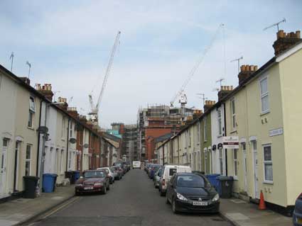
By April 2014, the view down Bulstrode Road has changed radically. But
then, as can be seen from the 1902 map further down on this page, this
end of this short terraced road used to overlook sizeable Malthouses,
so probably faced high blank walls...
 2014 image
A dramatic colour press photograph shows how close the Ipswich
Malting Company buildings were to the houses in Bulstrode Road during
the disastrous fire of September 20 1970.
 2021
image
2021
image
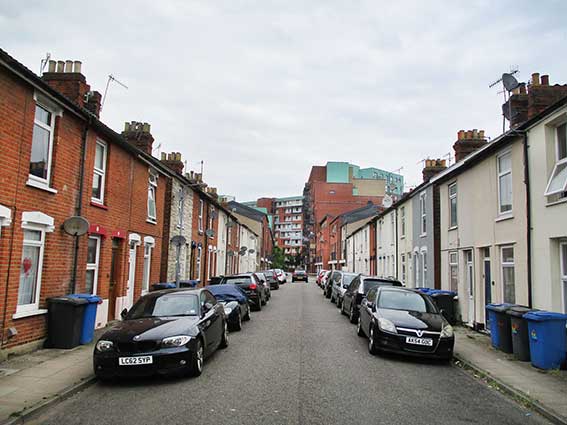
Above: the view from the end of Bulstrode Road in 2020
after the Genesis development was completed and residents had moved in.
We can see that the line of the road has
been continued into the estate, albeit separated by a removable barrier
which we assume will be used for emergency vehicle access if
necessary. Barnard Square runs off Great Whip Street (street nameplate
shown below) and is bollarded from the actual 'square'; a right-angle
turn leads to the new road shown in this photograph, which serves
Osprey Court and the new dwellings on the left which back onto Whip
Street Motors.
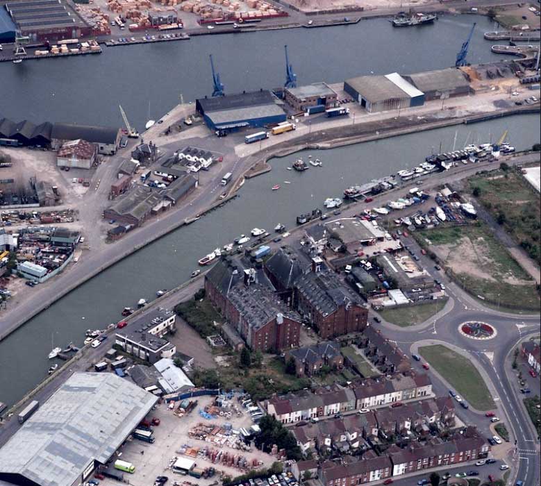
1990s aerial image courtesy The Ipswich Society
The above photograph was taken by Brian Mateer from a
light aircraft based at Ipswich Airport. At this time
(1990s) Felaw Maltings was empty and decaying and would not be rescued
until the end of the decade. New Cut runs across the top of the
photograph with the Public Warehouse on the Island site (top left),
then moving to the right, the lock-keeper's house, the Harbour Master's
Office (with four gables) and the oddly-shaped quay wall on New Cut
East which is the exit point for the original lock. Across New Cut and
just the other side of the huge maltings complex, is Felaw
Street and The Steamboat Tavern stands on the opposite corner. Vernon
Street
leads up from Stoke Bridge at the lower
right to meet the new
roundabout with Hawes Street going off to the right. Ip-City Centre now
occupies the ground to the upper right (at this time boats are stored
on the land close to the river at the end of Mather Way, presumably for
Debbage's Boatyard). Moving back
from the maltings
complex is Maltings Terrace,
behind the William Paul Tenement Trust almshouses
on Felaw Street. Then comes Bulstrode Road running from left to right
and lines with terraced houses and, closest to the viewer, Great Whip
Street. The image is taken from
the excellent Ipswich Society Image Archive (see Links).
More street nameplates
On the wall of the Coin Op launderette at the top of the
street is the sister nameplate to that found on the Steamboat. For
a photograph of the whole corner, see our Confectionery
page (Haward's 'Bake Office' lettering).
 2014 images
See Street name
derivations for the
source of Felaw Street.
For some us, the natural way to pronounce this name is with the
emphasis on the second syllable: 'Feh-law',
but the accepted pronunciation is 'Fee-law', with the stress on the first
syllable.
Great Whip Street
Around the corner is the Great Whip Street street nameplate. It
is one of the few in the town boasting not one, but two, superior 'T's
(see also St Georges Street)
'GT.
WHIP ST.'
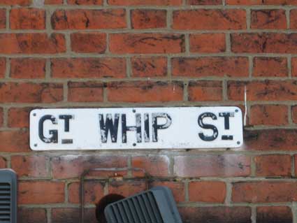
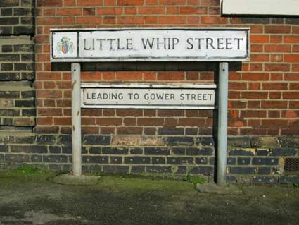
As yet, we have been unable to establish a firm derivation of Great and
Little Whip Streets (see Street name
derivations). Is it possible that there is a connection with
'whipping', as used in ropework? The significance of this street is
that it led directly into the ford, for several hundreds of years the
entry point into the town from the south – eventually Stoke Bridge
replaced it, of course. See the discussion below on the historical maps
for more on this. The more recent Little Whip Street
sign (above) has been
defaced with white paint by the look of things.
 2018 images
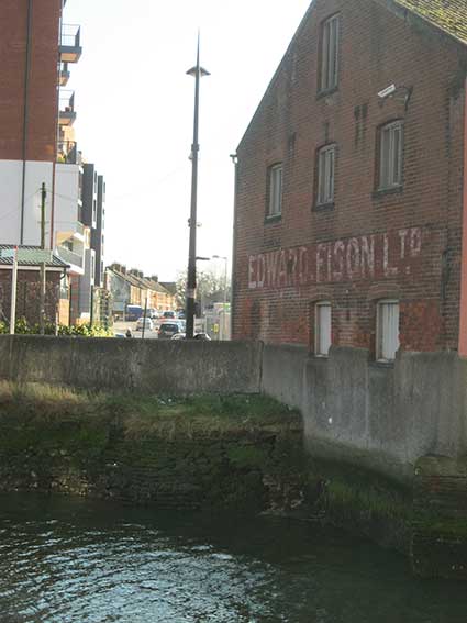
Above: Great Whip Street from the Island site looking
across New Cut. For more 21st century views of Great Whip Street and
the
place where the ford entred the river on the south side of the Orwell,
see our Edward Fison page. The
end wall of the redbrick building to the right is angled to the same
line as the original ford across the wide, shallow River Orwell at this
point (as shown on the maps below). Genesis is to the
left...
Genesis
 2021 image
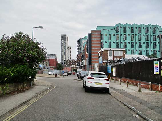
Above: a view down Great Whip Street with the Little Whip Street
junction at left. The Whip Street Motors scrap yard is at the left with
the characteristic (like it or not) pale turquoise elevation of the
Genesis housing development. The original Anglo-Saxon (possibly Roman?)
ford across the River Orwell is at the end of the road and The Mill towers above other dockside buildings
on St Peters Wharf. Here is the site of the 'Edward
Fison' painted sign.
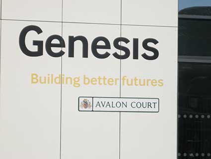
'Genesis', the name given to the large
accommodation complex fronting onto Stoke Quay, has been awarded
Ipswich
Borough Council street nameplates on the entrances to the blocks. This
example, 'Avalon Court' is on Great Whip Street, but a newcomer might
assume that the road was called something else. Other nameplates are in
place, such as 'Leven Court'; see our Courts
and yards page for more on the story of this term 'Court'.

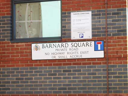
Below: an increasingly common sight in parts of Ipswich – street
nameplates with a short essay with a legal flavour:
'BARNARD SQUARE
PRIVATE ROAD
NO HIGHWAY RIGHTS EXIST
OR SHALL ACCRUE'
This example adds the bonus of an
Ipswich Borough coat of arms and 'No through
road' symbol. We believe that this legal exemption is
not
the work of the Borough, but of the Suffolk County Council Highways
Department who refuse to accept responsibility for any future repairs
or maintenance of the roads in some new housing developments. The
streets
around the Bramley Hill development off Woodbridge Road show a number
of further examples.
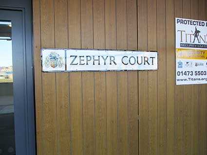
Below: the Zephyr Court nameplate fixed to the temporary surface
covering (hopefully) future shop units in Genesis, see from Stoke Quay.
The door to the left gives acces to the flats above. It's probably
quite breezy along New Cut, hence 'Zephyr': the Greek god of the west
wind.
 2021 image
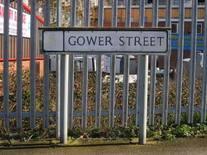
Gower Street
 2014 images
See Street name derivations for the
source of Gower Street. An insignificant street celebrating the
distinguished occupant of Nova Scotia House,
now the site of the West
Bank Terminal.
See also our Street nameplates
page for a cornucopia of examples.
 2021
image
2021
image
Above: the plain-ness of Gower Street seen from Little Whip
Street. At the far end: the white gable of Stoke
Bridge Maltings with
Paul's maltings silo to the left and Cardinal
Lofts with The Mill tower
block to the right (all three on St Peters Wharf). The green Genesis blocks are off to
the
far right, the modern extension to Vernon
Street Mission Room are off to
the far left.
The story of Felaw Street and environs.
The area in question is from Stoke Bridge (definitely pre-New Cut),
eastwards down Dock Street to the corner of the present day Island (End
Quay), south to the Public Warehouse, westwards past the Harbour
Master’s Office to The Steamboat Tavern, up Felaw Street and roughly
northwest back to the bridge.
Maps
The ford across the River Orwell
The earliest depiction is on John Speed’s map of Ipswich dated 1610. As
with other thoroughfares on this map, none of the streets are named,
but
their layout indicates which is which, even in the early 17th century.
Most of the buildings cluster around the southern end of Stoke Bridge
and at the corners of Dock Street, Bell Lane and Stoke Street. Such
clustering of buildings around busy junctions is common, particularly
with the
river crossing nearby. There appears to be a continuous line of
buildings
along Great Whip Street with few buildings beyond this area. Bell Lane,
although having a 'nip' to the north, appears to be as wide as Great
Whip Street. Little Whip Street runs
west to east into Great Whip Street. Muriel Clegg in Streets and street names in Ipswich
(see Reading list) goes into the discussion
of quite where the nothern entry to the forded river was located; the
history of land reclamation, new revetments and, ultimately, the
building of the Wet Dock in 1841/2 all make it difficult to envisage a
much wider shallower river with large marshy areas at this point. Clegg
acknowledges the arguments for a crossing-point at the southern
end of Foundation Street (passing to the west of St Mary-At-Quay
Church), but prefers John Glyde's suggestion of a 'Losegate' (a
southern gate into the ancient town) situated on or near the site of
the present day Foundry Lane. "If this is so, then we have an
illuminating picture of St Stephen's Lane coming up from the earliest
river crossing place to the heart of the market, and of St Peter's,
perhaps the minster church placed between the ford and the bridge, each
with its associated roadway. It is at least possible to think of this
as the centre from which the area was christianized."
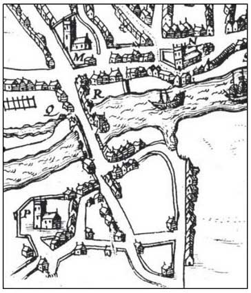 Speed map 1610 detail
The importance of Great Whip Street in the early history of Ipswich is
indicated on the 1610 Speed map by the
inlet of the Orwell at the northern end of
the street. This inlet does not show so clearly on later maps, however
it indicates that Wherstead Road and Great Whip Street was the main
thoroughfare from Colchester northwards via Stoke, across the Orwell
via a wide ford and into the heart of Ipswich. The road deviates to
meet the Stoke Bridge approach. Although there was a ‘Stoke
Bridge’ in existence from before AD970, it should not be assumed that
this was always the main crossing point over the river. John Norman
mentions that, although evidence has been found of Anglo-Saxon
settlement dating back to c. AD450, it took hundreds of years for the
town to build a bridge over the river. This gives the ford greater
significance than is sometimes acknowledged.
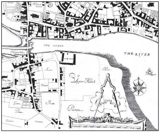 Ogilby map 1674 detail
Ogilby’s map of 1674 labels Little Whip Street, Great Whip Street,
Stoke Lane and Dock Street. The area to the east of Great Whip Street
is called Upper Marsh with, to the north, ‘The King’s Cooperage’.
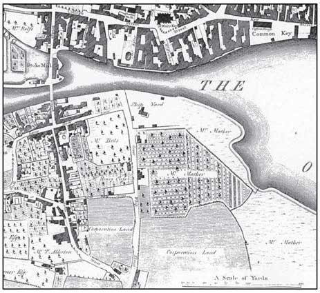 Pennington map 1778 detail
Pennington’s map of 1778 names the owner of this site: Mr Mather. A
large plot to the east of Great Whip Street is enclosed and appears to
be orchards or a plantation; the eastern point of the plot is close to
the Orwell shoreline. The marsh outside this plot is also labelled Mr
Mather. A Ship Yard is shown near the site of the previous cooperage.
This would connect with properties to the south via a drift way. The
land to the south is marked ‘Corporation Land’. Fewer houses are shown
fronting Great Whip Street.
By a plan of the proposed Wet Dock by John Bransby in 1836 (not shown
here), the New Cut would take waters from the Gipping and the
upper
Orwell, past the locked Wet Dock and down to the open sea. New Cut
would
divide the property formerly owned by Mr Mather (labelled on the 1778
map) and cut through the
western end of the drift way to the river. The plan also shows the
position of the
‘Union Workhouse’ (established in 1834) and the ‘Hospital Farm house’
relating, presumably, to Christ's
Hospital School.
Great Whip Street Workhouse
The new Ipswich Union purchased a 3.5-acre site on Great Whip Street
from Christ's Hospital at a cost of £525 for the purpose of erecting a
workhouse. Known as St Peter's workhouse, it was erected in 1836-7 at a
cost of £6,585 and was intended to accommodate up to 400 inmates. The
architect was William Mason who was also responsible for workhouse
enlargement schemes at Hartismere and Bury St Edmunds. The Great Whip
Street building was constructed in red brick. Its layout broadly
followed the popular cruciform or "square" design. Its entrance block
on Great Whip Street contained the board room and receiving wards. To
the rear, four accommodation wings radiated from a central octagonal
hub. The outer perimeter was formed from single-storey workshops and
outbuildings. A chapel was later added at the rear of the building and
also an infirmary block. The workhouse location and layout are shown on
the 1884 map below. For much more about this, see our Ipswich Workhouses page.
 Monson map 1848 detail
Monson’s map of Ipswich of 1848 shows the post-Wet Dock layout. The
island site is now separated from everything else by water apart from
the narrow access close to Stoke Bridge. A tide mill pond takes up a
large part of the island, with the original lock entrance from New Cut
to the south of it. The Union Workhouse is shown in detail with gardens
running down to the New Cut road and a continuous line of buildings
front the east side of Great Whip Street. A ‘Hospital School’ is shown
on the map south of the workhouse which is Christ’s Hospital
School which moved from
the Shire Hall/Blackfriars area in Foundation Street.
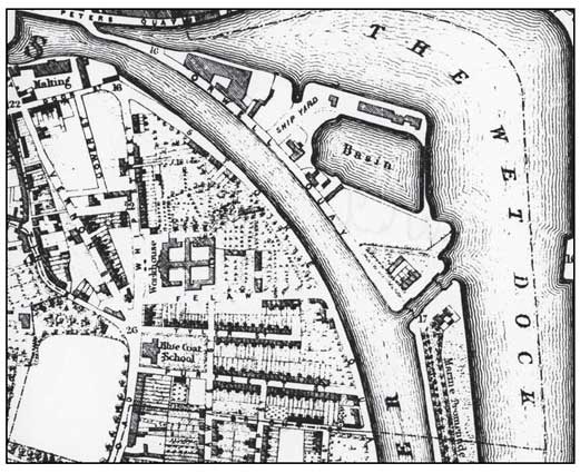 White map 1867 detail
By White’s map of 1867 the New Cut road is named ’Stoke Quay’.
Incidentally on this map what we now call New Cut West is labelled
‘Orwell Quay’. Again the workhouse and its gardens are shown bordered
now to the south by Felaw Street running east-west from Great Whip
Street to The Steamboat Tavern on Stoke Quay. Terraced houses line the
more-or-less parallel Tyler Street with 'The Blue Coat School' (Christ's Hospital) on the
corner of Wherstead Road and Tyler Street, since Vernon Street has been
built truncating the south of Great Whip Street. The new streets
include those named after benefactors of the town’s charities: Felaw,
Tyler and Purplett (originally Puplett/Purpett) (see Street
name
derivations).
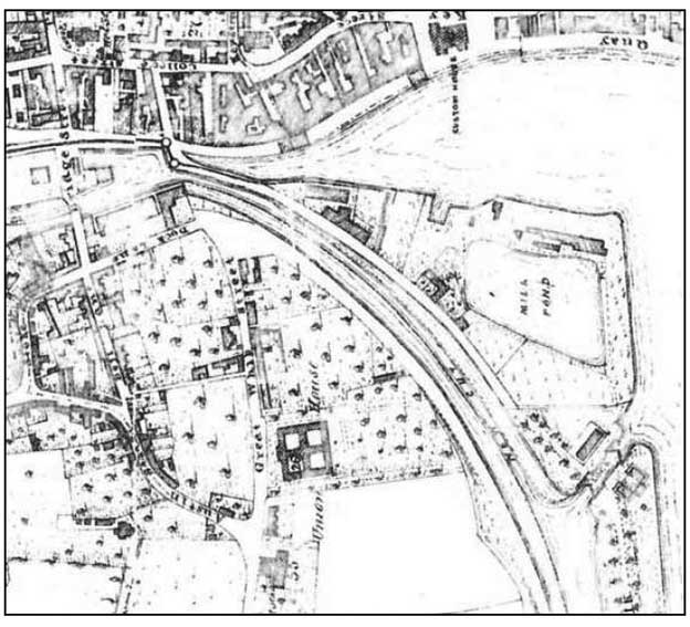
 O.S. map 1904 detail
By the first edition Ordnance Survey map of c.1885 (not shown)
Stoke Quay was renamed ’New Cut West’with ‘New Cut East’ over the
water. Little else has changed apart from the labelling of ‘Christ
Hospital School (Boys)’. The second edition O.S. map of 1904 shows that
the workhouse has been demolished and part of the site used for houses
along Great Whip Street and either side of the newly formed Bulstrode
Road. The workhouse orchards and gardens are gone, replaced by
malthouses and railway sidings providing access for them. The railway
would have come off the main line, crossing Wherstead Road by the
bridge still seen today and curving round past the end of Bath Street
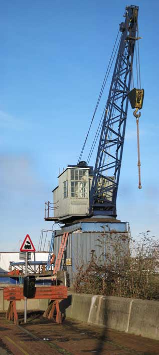
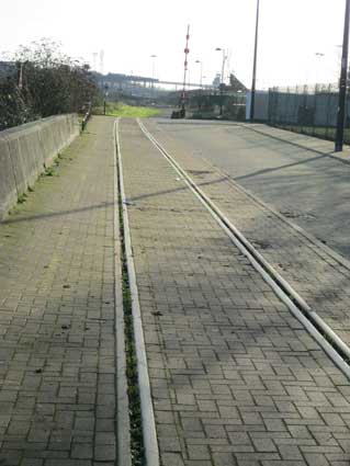
and on up New Cut West. There is still a railway/tramway – relaid in
recent years – as far as the old crane at Debbage Marina (see
photograph below).
It is difficult to make sense of the old road layout
since the
introduction of new traffic schemes in modern times, but Dock Street,
Bell Lane and Stoke Street, Little Whip Street and Great Whip Street
can still be identified, albeit often in truncated forms. The other
road bearing an ancient name is Austin Street which today runs off
Stoke Street down to Wherstead Road at Tyler Street. It can be seen on
all the historical maps running into Great Whip Street, the main
thoroughfare to and from the ford on the Orwell. The name
‘Austin’ is associated with the parish of St Augustine’s, which was
mentioned in Domesday as having existed in 1086. Like St George’s (see
St Georges Street and our Lady Lane page), St Augustine’s leaves only
uncertain traces in the records after the reign of Edward II
(1307-1327) and was probably in decay at the time.
There was St Leonard’s (leper) Hospital “in the area of the later Felaw
Street and Tyler Street”. It is said to have survived the dissolution
of the monasteries and there are references to it in the late 16th
century. Perhaps St Leonard’s Hospital was built on the site of the
redundant church of St Augustine. Before the Grammar School which stood
on the old Blackfriars Priory site in Foundation Street was demolished
in 1851 and John Blatchly tells us that “Chenery’s farmhouse in Great
Whip Street was adapted for the purpose”. The new school opened in
1841. During excavations piles od bones were found suggesting the
burial ground of St Augustine’s Church and/or the burials from the
leper hospital.
To quote the Suffolk County Council Archeological Unit report on 9-11
Great Whip Street, Ipswich:
“... the Grammar School and the Blue
Coat School were two separate charitable institutions. The Grey Coat
and Blue Coat School Trust was established in 1709 and rented premises
“Lockwood’s Room or chamber in St Mary Tower parish” for the school.
Amongst abstracts of the various bequests to this
charity Mileson Edgar in his will of 1712, left money for “The Charity
School in Brook Street” and Richard Philips left money for “the
maintenance of the hospital …and towards the support of the Charity
School there”. Both entries suggest that the school was then part of
Christ’s Hospital. In the
minutes of the Charity there is a reference
to the purchase of a house in St Mary Elms in January 1771. The
building was altered in 1857 when
the girls’ schoolroom and master’s house were demolished, though the
architectural plans of R. M. Phipson’s have not survived. In 1876
Phipson prepared plans for a new school to be built in Curriers Lane.
The school was for Anglicans only and the pupils were obliged to attend
services at St Mary Tower. White’s Directory of 1874 gives the address
for this school as Elm Street and it is strange that White’s map of
Ipswich of 1867 shows the position of the school in Great Whip Street.
Unfortunately neither Clarke nor Wodderspoon offer any description of
the Blue Coat school buildings.”
The area of land to the south marked ‘Corporation Land’ in 1778 south
of Little Whip Street is probably part of ‘Hospital Farm’.
The above passage is based on:
http://archaeologydataservice.ac.uk/archiveDS/archiveDownload?t=arch-415-1/dissemination/pdf/suffolkc1-72933_1.pdf
Griffin Wharf Branch, New Cut West
... or Griffin Wharf Branch leaves the main line at Halifax junction
(built in 1847),
close to the site of the old goods sidings and original station, curls
over Wherstead Road (where the road looks as if its been excavated to
allow clearance of the bridge by later electric tram traffic), lands
close to the site of Nova Scotia House,
a fine mansion now lost to us and home of Captain Richard Hall Gower,
naval architect (see Gower
Street in Street name derivations).
Curving round to complete an 'S' shape, the line runs round Griffin
Wharf; this is named after the long-disappeared Griffin Inn. The
invaluable Suffolk CAMRA site (see Links)
tells us that The Griffin Inn stood on the corner of New Cut West and
Bath Street. It was demolished so that Ransomes and Rapier could expand
their works site. The inn is also listed at Black Wall, New Bank
(1844), Steam Packet Wharf (1855), Griffin Wharf (1865+1869) and New
Foundry (1871).
The branch served the sites of engineering companies Cocksedge &
Co. and
Ransome & Rapier among others (see the 1973 Wet Dock
map). With the building of the West Bank Terminal on the sites of
the Stoke Bathing Place, Nova Scotia House and Halifax shipyard in
1973, the tramway was extended back into the terminal for freight use.
The trains to and from Griffin Wharf ceased in 1993, however in July
1997 rail freight traffic resumed at Griffin Wharf.
 Tramway
looking towards West Bank Terminal, 2014
Tramway
looking towards West Bank Terminal, 2014
Above: the Griffin Wharf Branch in 2014 where it terminates near to
Debbage Yachting on New Cut; at this point the railway becomes a
tramway
unfenced from the road linking Bath Street and New Cut West. In 2019 we
understand that fortnightly freight trains used the line to serve the
West Bank Terminal coming up towards the buffers, then reversing wagons
into the terminal.
A tramway is a
set of rails laid in the surface of a road,
rather than being raised on sleepers and a clinker bed. Although
customarily used by tramcars in towns and cities in Victorian and
Edwardian times (trams having had something of a rebirth in the late
20th century), these tramway lines have also been used by horse-drawn,
steam and diesel vehicles particularly for the moving of freight wagons
– exactly as we see around the Wet Dock and beyond (see our Wet Dock map page for an explanation of the
growth of both rail and tramway access to the dockland area of Ipswich).
Below: a photograph found by Over Stoke History Group. "J15
locomotive
No. 65459 crossing 'Black Bridge' over Wherstead Road on 4th April
1959. The 0-6-0 engine, built at Stratford Works in 1906, is seenwith a
short goods train, including a train-ferry wagon, between Griffin Wharf
and Halifax junction."
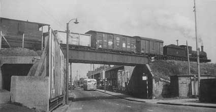 Photo collected by
the Over Stoke History Group
Photo collected by
the Over Stoke History Group
This bridge also features on our Railway
bridges page because it is numbered.
[UPDATE 2020: the advent of the
tidal flood barrier at the entrance to New Cut has caused Network Rail
to fence off the (formerly) publicly accessible tramway all the way up
to the boatyard. Which makes access to the public observation platform,
which was part of the design of the barrier site, impossible.
Interesting, when we hear that the only freight trains to trundle over
the Wherstead Road bridge and on to the tramway, then reverse onto the
West Bank to load up with sand and gravel, occur once every fortnight.
Let's hope this eyesore can be removed soon.]
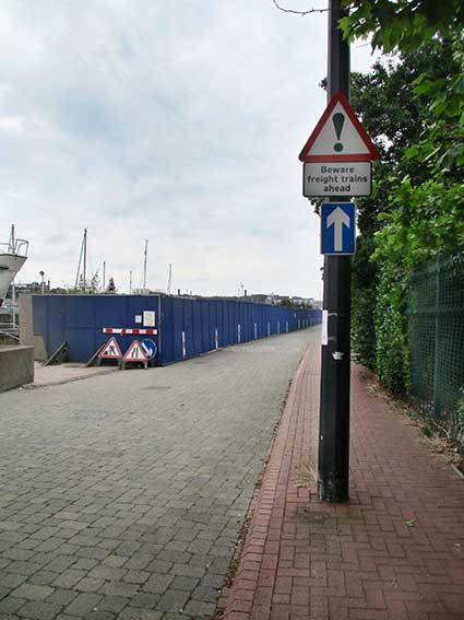 2021
images
2021
images
The view in 2021 down New Cut West towards the Bath Street corner shows
the road sign: 'Beware freight trains ahead'. The triangular road sign
showing a puffing steam engine can just be seen above the blue
shuttering.
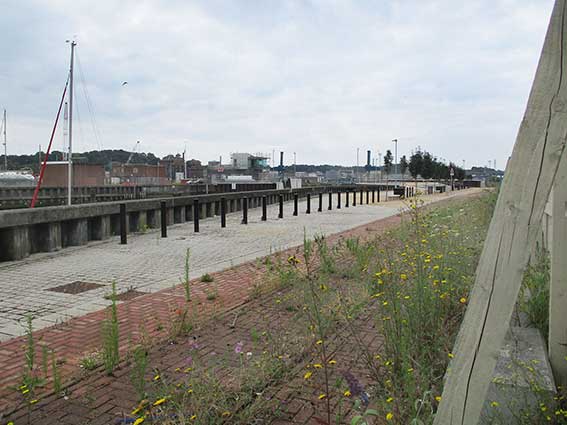
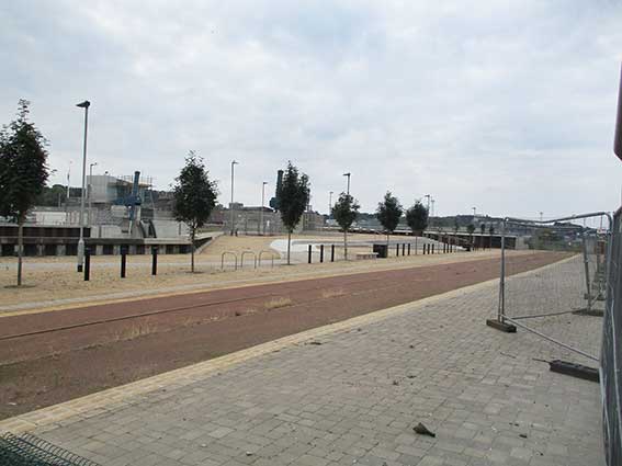
Above left: a rectangle cut in the shuttering reveals the overgrown
tramway tracks within the red paviors. Above right: a view past
the end of the shuttering showing the tramway disappearing towards the
West Bank Terminal, with hard and soft landscaping of the public area;
the control building of the tidal flood barrier rises at the left.
Bicycle racks and seating are somewhat redundant at this date.
See also other aspects of Felaw Street with the 'Bake Office' lettering and Wm. Pauls' Tenement Trust buildings.
See also our Lettered castings
index page.
Home
Please email any comments
and contributions by clicking here.
Search Ipswich
Historic Lettering
©2004 Copyright
throughout the Ipswich
Historic Lettering site: Borin Van Loon
No reproduction of text or images without express
written permission