Bourne
Park / Ransomes
& Rapier / Stoke Park Mansion / Bourne
Bridge
These
contributions about the park memorials come from Mike O'Donovan (M'OD),
summer 2010, with his own
emailed commentary. They are supplemented by images and memories from
Steve Girling (SG). Bourne Park lies away from the town centre
with main entrances at the end of Wherstead Road and on Stoke Park
Drive.
The War Memorial
April 2020: We are pleased to add The Ransomes & Rapier War Memorial research paper by Jean Austin to this
website (scroll down to the update).
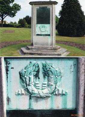
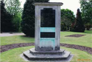
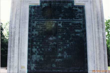
'Here is a set of photos showing the memorial at Bourne
Park. It has
three sides and the photos show one side and the inscriptions on that
side.
 Photographs
courtesy
Mike
O'Donovan
Photographs
courtesy
Mike
O'Donovan
The
inscription at the bottom (below the crest) reads:
'THIS TABLET IS ADDED TO THE MEMORIAL AS
A TOKEN FROM THEIR FELLOW WORKERS.'
The main
text of the memorial is shown next to the
photograph of the weather-worn plate:
 -
-
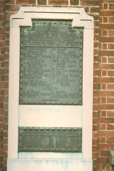
Here are
some more from the same memorial, side 2.
Again the
weathered metal plate and the full text
beside it:

The metal
plaque at the bottom reads as follows:
'CIVILIAN
CASUALTIES
MRS
ANTHONY
S. CORNISH
C.F.
CRIPPS
H.L. JUDD
E.
QUINTON
H. ROBERTS
P.N
SHARPE
O. MAYES
F.
WHITING
W.W. SEARLEY'
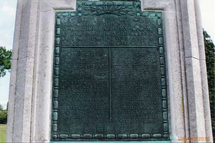
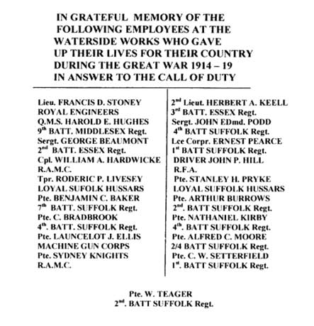
One of those listed in the
first World War I memorial is Pte. Nathaniel Kirby, 4th Battalion
Suffolk
Regiment. See our Stoke Hall Road page for a possible/disputed link to Stoke Hall and Kirby Cottage on Belstead
Road.
"These are the last from the monument [the statement carved into the
stone]:
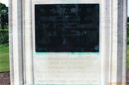
"THESE
MEMORIALS WERE REMOVED
FROM THE FORMER
RANSOMES & RAPIER
WATERSIDE WORKS CANTEEN UPON
THE CLOSURE OF THE COMPANIES
[sic]
MANUFACTURING FACILITY IN 1988"
Surprising really that
there is such a lot of history involved which is practically unknown to
many people. Sadly, the name of the individual mentioned on the plaque
has been removed as you can see from the statement at the bottom.
However, the person mentioned is Richard Stokes (1897 - 1957). His
mother's family was involved in the engineering firm Ransomes &
Rapier and he was a Labour MP. The metal plaque
reads as follows:
'CHAIRMAN
& MANAGING DIRECTOR
OF
RANSOMES & RAPIER LIMITED
1927 - 1957
MEMBER OF PARLIAMENT FOR IPSWICH
1938 - 1957
HIS MAJESTY'S MINISTER OF WORKS
1950 - 1951
PRIVY COUNCILLOR
1950 - 1957
LORD PRIVY SEAL & MINISTER OF MATERIALS
1951' "(M'OD)
So where did these memorials come from?...
Ransomes & Rapier memorials
Richard Rapier Stokes
Contributions from Steve Girling: 'I worked at
Ransomes & Rapier in the Maintenance Dept.
I started my
apprenticeship there in 1980 and was made redundant in late 1986.
For some reason when I was working during the summer shutdown of 1985,
I
went round the factory and took some pictures of the plant etc.
(unfortunately I didn't get a photograph of everywhere). I have given a
copy of these photos to Elizabeth Scott Townsend (who is a descendant
of R C Rapier one of the founders of the firm) and who organises the
annual reunions. I also gave permission for a copy of them to be given
to the Ipswich Transport Museum for their "Engineering in Ipswich"
section. It seems that I must have had a feeling that some of the
factory
needed photographing!' We are very
grateful to Steve for these fascinating photographs.
 Photographs
courtesy Steve Girling
Photographs
courtesy Steve Girling
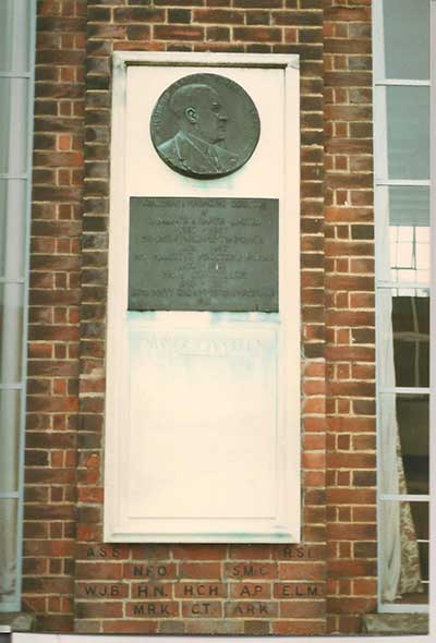
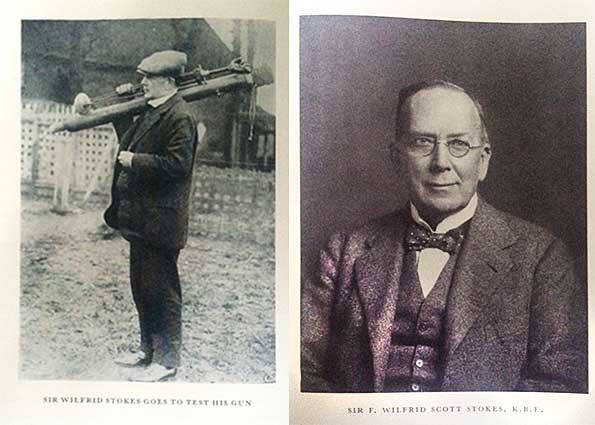
First, the memorial to Richard
Rapier Stokes as it was originally mounted. The roundel contains the
name and dates. His uncle, Sir Wilfrid Scott Stokes,
was the inventor of the Stokes mortar (see below).
‘RICHARD RAPIER STOKES (1897-1957)
[followed, on the rectangular plate by the text as shown
above:
'CHAIRMAN
& MANAGING DIRECTOR etc.']
on the stone panel below is carved:
‘RAPIER CANTEEN… [unreadable]’
and on the brickwork below that (painted in black characters):
‘A.S.S. R.S.L. N.F.D.
S.M.C. W.J.B. H.N.
H.C.H. A.P. E.L.M.
M.R.K. C.T. A.R.K.’
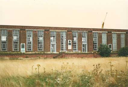
"Please find attached some photos of the Ransomes & Rapier
war memorial tablets which are now in Bourne Park, the photos were
taken in the mid eighties when the tablets were in their original
position on the wall of the works canteen facing the bowling green."
(SG)
Below: the tablets in place on the wall of the Ransomes & Rapier
works canteen.
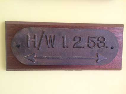
"I have a high water level mark plate from
Ransomes and
Rapier, it was on the 'gate house' along Rapier St, you had to cross
Rapier St to get to the Packing Shop Dept.; unfortunately I never
measured the height of it on the wall but from memory it would have
been
18 inches to 2 ft high, I assume it would of been cast in the works
foundry and I think there were a couple more around the factory. I have
since mounted it on a piece of wood.
[UPDATE 1.4.2020: 'My husband
discovered your website this afternoon when he was searching for
Ransomes mowers.
I've only looked at a bit of it but there is wonderful information here
- especially as I love local history. I note on one page
you mention Lord Gwydr - and I wondered if the attached info and photo
of his funeral at Belstead churchyard is of any interest - Yew trees
were planted at each corner of his grave and they are still there [please scroll down to see this remarkable
photograph]. You
also mention the R&R war memorial in Bourne Park - I researched the
'stories behind the names' and then 'Graham Jones' added additional
information on the circumstances of some of the deaths and then Steve
Girling got in touch with me - after I'd asked if anyone had photos of
the memorial plaque to Richard Stokes - and that is how his wonderful
photos of R&R came 'out' and (with his agreement) are now in the
Ipswich Transport Museum and the Suffolk Record Office and Elizabeth
Scott-Townsend has them. I wondered if this information was of
any interest to you. Regards, Jean Austin.' We are most grateful
to Jean for getting in touch. We are delighted to be able to include
her research here to add to The Ransomes &
Rapier War Memorial story. If
you would like to contact Jean, please use the 'Contact us' link at the foot of
this web page and we will forward enquiries.]
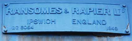
Ransomes
& Rapier's Waterside Works
Click to view a 1940s
booklet promoting Rapier products reproduced from The British Machine Tool Engineering
magazine – note the illustration on page 2 showing the Waterside Works,
taken from a painting by local artist Leonard Squirrel.
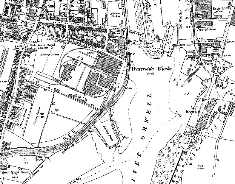 1904 map
Above: a map of Griffin Wharf showing the Ransomes &
Rapier Waterside Works in its heyday at the beginning of the 20th
century. The Griffin Inn (demolished in
1951 to accomodate an extension to the Waterside Works), which gave the
wharf its name is on the southern corner of Bath Street as it meets New
Cut West. It is marked 'Inn' and the 'Griffin Ferry' with a dotted line
to the Island site and Promenade ran from
just outside the inn (note that 'The Umbrella' shelter is labelled).
The
next buiding to the south is the 'Griffin Mill (Manure)' which
processed phospahatic nodules into agricultural fertiliser, as did
Edward Packard's factory in Coprolite Street.
The next road down is Harland Street – long disappeared under modern
housing – and the G.E.R. branch railway can be seen
along the wharf with a tramway round and into the works. 'Nova
Scotia House' is at the bottom left.
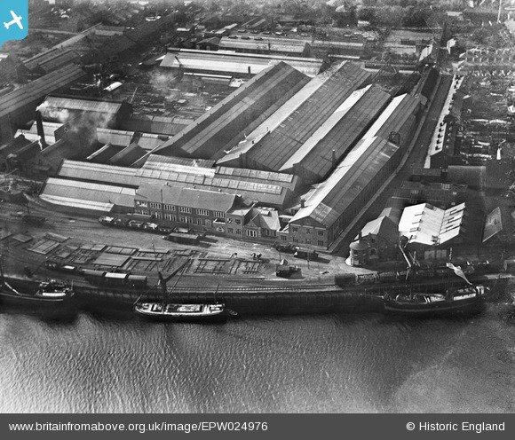 1928 image
The above 1928 photograph comes
from the excellent Britain from above
website (see Links) – if you subscribe for
free, you can examine and zoom in on images. Harland Street runs away
from the wharf with a curious rotunda attached to the building on the
northern corner of the junction with New Cut West. Nearby, three heavy
horses await their next goods trucks to be hauled into and out of the
Waterside Works on the tramway. The G.E.R. branch line can be seen
along the edge of the quay with steam-hauled goods. Between the horses
and the railway is a lattice of right-angled supports for the temporary
storage of the products of the engineering works. New Cut itself is off
to the right; the west banks of the River Orwell continue to the left.
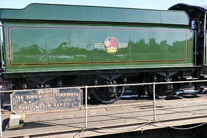
Ransomes & Rapier products spotted
out in the world
Below: Ransomes
& Rapier turntable at The
Nene Valley Railway, Cambridgeshire in May 2017.
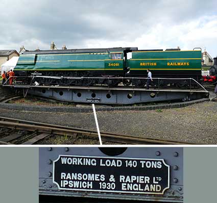 2017
photograph
courtesy David Gaylard
2017
photograph
courtesy David Gaylard
Below: 'Another couple for your collection. Taken at Tyseley steam
depot open day, near Solihull. D.G.' The sleek mallard green paintwork
and British Railways transfer of the tender contrast with the
cartouche-cut cast iron branding plate, prominently sited on the
turntable railings by Ransomes & Rapier – here using the boxed
namestyle 'RAPIER'. The date of manufacture and even the British
Railways contract number are included. The Tyseley
steam museum doesn’t seek to over-restore the
paintwork, but leaves the plate showing its age.
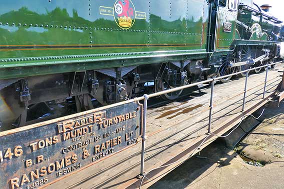 2018
images
courtesy David Gaylard
2018
images
courtesy David Gaylard
'[RAPIER]
146 TONS MUNDT TURNTABLE.
MADE FOR
B.R.
CONTRACT NO. 1114 – M&E
BY
RANSOMES & RAPIER LTD.
OR. G.J.4985 IPSWICH. ENGLAND.
1957'
The 1921 advertisement (below) from the excellent Grace's Guide
website (see Links) proudly displays the full
company name in stylish lettering, giving their London offices address.
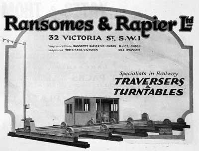 1921
1921
Below: Ransomes worldwide.
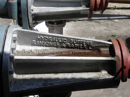 Photo
courtesy Mark Beesley, 2014
Photo
courtesy Mark Beesley, 2014
Mark Beesley took the above photograph in Kalka in India, at the
railway station which is the terminus for the narrow-guage 'Toy Train'
that runs up through the hills to Shimla. The relief lettering on the
buffer casting reads:
'HYDRAULIC BUFFERS
RANSOMES & RAPIER LTD.
IPSWICH 1927 ENGLAND'
The Ransomes Engineering breakaway
company of Ransomes &
Rapier Ltd, founded in 1869 and based at the Waterside Works
close to
Griffin Wharf (see Wet Dock map), soon
made a name for itself that was second to none. In the 1870s it took a
leading part in supplying equipment for the Welsh narrow-gauge slate
railways, and also for similar railways on sugar plantations far across
the sea. Ransomes & Rapier made equipment not only for railways in
Britain but for lines in China, India and other parts of the world;
they manufactured sluices for the Aswan Dam and for other water control
schemes, and built the biggest walking dragline in the world. A
testament to their quality and workmanship is the excellent condition
of the Kalka railway buffer housing kindly photographed and sent in by
Mark. Incidentally, Stoke Hall which once
stood off Belstead Hill was the home of Robert James Ransome
(1830-1891) of Ransomes and Rapier – see that page for a resumé of the
company history.
[UPDATE 19.1.2022: Ipswich
roping expert Des Pawson (see Links) has got
hold of a copy of a catalogue from Thos & Wm Smith, Wire rope makers,
Newcastle. circa 1896-1901 – the document found in Australia. It has
three Ransomes & Rapier cranes illustrated (for the Manchester Ship
Canal, the Madras Harbour Board and Great Eastern Railway Co., Harwich)
as well as a full written description of the Harwich one and a
testimonial to the quality of the wire rope. Click the link to view the
PDF file – and thanks to Des for sending selected pages from the
catalogue (perhaps a unique copy).]
Many other examples of Ransomes & Rapier and Ransomes Sims &
Jefferies products can be found all over the world.
The Stokes Mortar (Sir Wilfrid Scott Stokes)
Steve Girling continues:
'... Two pictures (sorry, they're blurry – they are copied
from a slide) taken in the mid-eighties before the R&R factory was
demolished, I assume the plaque was 'lost' in the demolition, the
plaque was on a wall in the Hydraulic Bay at the Wherstead Rd end of
the Top Shop Dept.'
 Photographs
courtesy Steve Girling
Photographs
courtesy Steve Girling
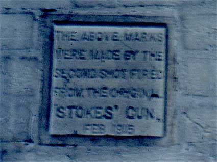
The plaque reads: 'THE ABOVE MARKS WERE MADE BY THE SECOND SHOT
FIRED FROM THE ORIGINAL 'STOKES' GUN. FEB 1915'
From Grace's Guide (see Links):
'Sir (Frederick) Wilfrid Scott Stokes (1860-1927), civil engineer and
inventor of the Stokes gun, and managing director of Ransomes and
Rapier.
1885 Joined Ransomes and Rapier of Ipswich as assistant to Richard
Christopher Rapier, the managing director.
1907 became chairman of the company, holding both top offices until his
death.
WWI [World War I] Designed the Stokes gun [or Stokes mortar] in
response to the army's need for a lightweight, portable mortar. It was
rejected by the War Office in December 1914 because many shells missed
their targets, but the gun was subsequently used in the trenches at the
battle of Loos in September 1915, firing smoke shells.
1915 Stokes was one of the scientists and engineers involved in the
munitions invention department.'
The Stokes mortar remained in service into the World War II, when it
was superceded by the Ordnance ML 3 inch mortar, and some remained in
use by New Zealand forces until after the Second World War.
'...some photos I have taken from a book celebrating the first 80 years
of Ransomes & Rapier [80 years of
enterprise 1869-1949] from
which you may get some helpful info.'
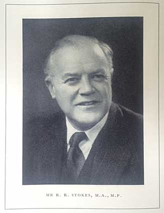 Mr R.R. Stokes, M.A., M.P.
R.R. Stokes became Managing Director of Ransomes & Rapier in
1927 and was MP for Ipswich from 1938 (later Minister of Works and a
Privy Councillor) ... 'who is named on the memorial tablet now in
Bourne Park.'
'Thought you may be interested in this silver medallion given for war
work at Ransomes & Rapier; it was issued unnamed. I have got 2 of
these in my collection.' (SG)
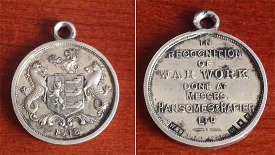
'1918 / IN RECOGNITION OF
WAR WORK DONE AT MESSRS. RANSOMES & RAPIER LTD.'
The hallmarks on the reverse (including the silversmiths:
'W&S') indicates that this is a medal containing silver which meets
the sterling standard of purity: the Lion Passant. The
obverse side features the Ipswich coat of arms
and the date.
 See our Island
site page for the Ransomes & Rapier lock swing-bridge.
See our Island
site page for the Ransomes & Rapier lock swing-bridge.
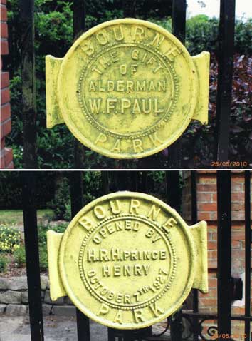
The park gates (Alderman W.F.
Paul, Prince
Henry)
The
two images below are on the
gates at the entrance to the Bourne Park.
'BOURNE
PARK...
THE GIFT OF ALDERMAN W.F. PAUL'
'BOURNE PARK...
OPENED BY H.R.H. PRINCE HENRY OCTOBER 7TH
1927'
'The Prince
Henry mentioned was one of the sons of King
George V and was born in 1900 and died in 1974. He was one of the
present Queen's uncles. As a matter of interest he and his wife appear
on a 1945 Australian postage stamp. By the way, the Ipswich Lettering
site keeps
getting better. It's a marvellous record of the town. '(M'OD)
See our page on More almshouses for
more about the W.F.
Paul Tenement Trust. See our Paul's malting page for the story of the
company and its importance to Ipswich.
 Photographs
courtesy
Mike
O'Donovan
Photographs
courtesy
Mike
O'Donovan
Grateful
thanks to Mike O'Donovan for these examples
and the background detail. An anecdotal addition: the garish yellow of
the cast iron gate memorials above seem to sum up the state of
Bourne Park in around 2009: a bit run down. In cycling down the whole
length of
Constitution Avenue, as we discover it's called, from Stoke Park Drive
(see note below) to the Wherstead Road entrance, one finds a pleasant
public park – with
good children's play area – bordered by housing, scrubland, Belstead
Brook, a main road
and a railway line. A bit depressing, those boarded-up wrecks of
buildings at the Wherstead Road entrance. They ought to get someone to
live in the corner one with the clock (get it to tell the right
time...) and sell ice creams and teas from the smaller one.
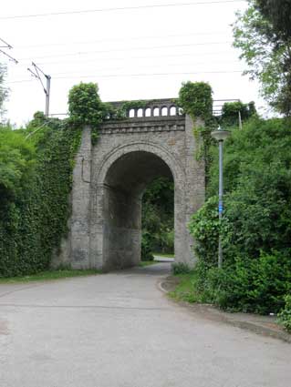
The Arch / Arch Cottage
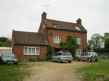 2013 images
Down to Arch Cottage and the gentleman who lives there was very
forthcoming. His cottage was built in the 1700s, when it must have
stood in open land with a view of the river at Bourne Bridge (see
below). This, of course, was long before the nearby
embanked railway (initially the Eastern Union
Railway in 1846,
terminating in Station Street near Croft Street until the station moved
to its present site in 1860) and
had two acres of land including the current caravan site. While this
gentleman was in the RAF, his father sold the adjacent front lawn to
his brother who built a house on the site: Meadow Bank Cottage (visible
through the arch, below). He was
obviously born and bred there as he remembers the steam trains going
by. He loves trains: 'You can set your watch by them'.
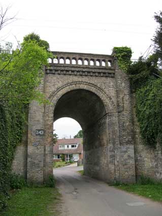
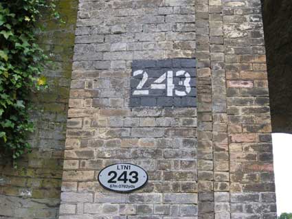
The
impressive arch which allows public access through
the
embankment to the park (and, of
course, the two cottages) is worth a look. It bears a stencilled number
as with so many railway bridges around
the town. But what was Arch Cottage
called during the many years before the railway – and the arch
– arrived?
See more details on the railway and Stoke Tunnel
on our EUR, Croft Street page.
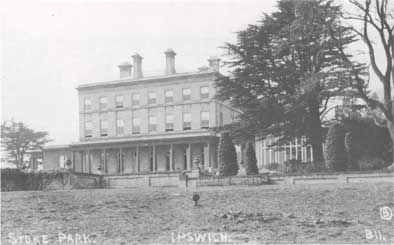
Stoke Park Mansion (home of
Peter
Burrell, Lord Gwydyr)
The name "Stoke Park" can be
confusing: in the early 1900s it
was a large estate and the home of Peter
Burrell who became Lord Gwydyr in 1870, County
Magistrate and High Steward of Ipswich (see our Street
name derivations entry for Burrell Road and Gwydyr Road – including
a suggested pronunciation). We're calling the house
'Stoke Park Mansion'.
 Postcard
of Stoke Park, 1914
Postcard
of Stoke Park, 1914
The small print (postcard?) below is attributed to 'F.B. Russel'
(Frederick Brett Russel, 1813 - 1869, who worked from a studio in
Berners Street, Ipswich), published by 'Capone'. It shows 'STOKE PARK,
NEAR
IPSWICH; THE RESIDENCE OF ROBERT BURRELL, ESQ.' Robert Burrell (Peter
Robert Burrell) occupied the mansion until 1909, so the depiction of
the house pre-dates his death.
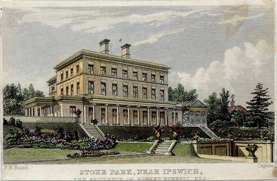 Courtesy Francis Beaumont
An 1885 directory describes Stoke Park – not to be confused with
Stoke Hall
mentioned above – as a handsome mansion in a well-wooded park of 500
acres, commanding beautiful views of the river. It was the private
house of Lord Gwydyr, but was a favourite place (presumably the
parkland?) for Sunday School treats and children's outings. It was
demolished in 1930 but some of the mature trees apparently still stand
on the Stoke Park housing estate around the Bourne Park area to the
west of the Orwell. The map below gives some idea of the house and its
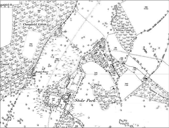
surroundings, including 'Icehouse Covert'. Note the legend 'Round
House' to the west of the main house (see also the early 1930s map
below).
W.M. Roberts' book Lost country
houses of Suffolk (see Reading list)
gives a fascinating glimpse of this vanished mansion.
Stoke Park (demolished c. 1930)
Stoke Park stood to the south of the road from Ipswich to Belstead
village. It was in the parish of St Mary Stoke, which was in the
Liberties of Ipswich. It was described in 1918 as lying ‘upon an
acclivity rising from the Western bank of the River Orwell, and
commands exceedingly beautiful prospects of the scenery along the River
Banks’.
The manor of Stoke was held before the Reformation by the Abbey of Ely.
On the Dissolution of the Monasteries it passed to the Dean and Chapter
of Ely Cathedral. By the early 17th century an interest in Stoke Park
was held by William Acton, who left it to his cousin, also called
William Acton. The 1829 edition of The
Suffolk Traveller refers too ‘the manor of Stoke-hall, by which
we do not mean the modern house by the church but what is now called
Stoke-park’, stating that it was held by Nathaniel Acton of the Dean
and Chapter of Ely.
A map dating from 1787 shows an unnamed building located near the site
of Stoke Park and one dating
from 1801 shows Stoke Hall on
the north
side of Belstead road near the church of St Mary near the Orwell. Even
at this early date there seemed to be a need to distinguish the two
houses. In 1840 Stoke Park was acquired by the Honorable Merrick
Lindsey Peter
Burrell, a member of a family whose seat since the late 17th century
had been at Langley Park, Beckenham in Kent. It seems likely that the
estate came on the market following the death of Nathaniel Lee Acton in
1836.
M.L.P. Burrell was the younger son of the first Lord Gwydyr who married
the eldest daughter of the Earl of Ancaster (see
Street name
derivations for Ancaster Road). Burrell died
in 1848, to
be succeeded at Stoke Park by his eldest surviving son, Peter Robert
Burrell (see Street
name
derivations for Burrell Road), who became
the fourth Lord Gwydyr, succeeding a cousin in
that barony. Peter R. Burrell died at the age of 99 in 1909. On the
death of his only son six years later the barony became extinct and the
Stoke Park estate was inherited by his granddaughter, the wife of Sir
John Henniker Heaton. Lady Henniker
Heaton put the whole estate up for auction in 1918, with the house
contents being sold the following year. After various auction/sale
attempts, Percy Barker owned much of the estate by 1922 and he sold
seventy-six acres of it to Alderman W.F.
Paul. He presented it to
Ipswich Borough Council for a public park (Bourne Park – see the gate
medallion images above). The date of demolition of the mansion is
unclear, but by 1935 a new house had been built to the design of local
architect H.R. Hooper. Ironically, perhaps, this house was itself
demolished in 1968 and the estate was acquired for housing development.
Over fifty years, the whole of the Stoke Park estate, apart from the
Stoke Park Wood local nature reserve (see below) and Bourne Park, had
become a suburb of Ipswich.
Stoke Park is stated to have been 'built on the site of an old house of
the same name according to plans approved by Peter Lord Gwydyr'. Little
is known about the house that it replaced, except that the Tithe Map of
1840 shows a large building consisting of two blocks, the south side of
one overlapping continguously the north side of the other. The
new house may have been designed bu Richard Makilwaine Phipson, but
that is by no means certian. It had eight bays on the south (garden)
front and five on the flank, the windows on the upper floors being
sashed. It was a three-storeyed building with a wing projecting to the
rear on the west side and a two-storeyed wing to the north-east
containing the domestic offices. It was built of white Suffolk bricks
with a hipped roof and string courses. The entrance was at the southern
end of the west front with an Ionic-pillared porte-cochere leading into
a single-storeyed entrance hall. On the garden front there was a
single-storeyed open collonade of nine pillars onto which French doors
gave access. [See the coloured illustration above.] On the east front
there was a single-storey extension matching the entrance hall and
leading to a conservatory.
The house had five 'noble entertaining' rooms – saloon, two drawing
rooms, library and dining room together with a billiard room and study.
The main rooms had decorated ceilings and marble chimneypieces, the
principal drawing room being decorated in the Adam style with a marble
and scagliola [imitation mineral made of plaster mixed with glue and
dyes which is then painted or polished] chimneypiece inlaid to
represent fluted columns with Ionic capitals. The oak staircase from
the saloon led to thirteen bedrooms in the south wing, those on the
first floor being arranged in two suites of three rooms each. The west
wing contained four bedrooms on each floor. In all there were three
bathrooms.
The domestic quarters in the north-east wing provided all the offices
normally required in a house of this size – butler's pantry strongroom,
housekeeper's room, servants' hall, kitchen, scullery, larder, laundry
rooms, game larder, brush room, lamp room, knife room, shoe room, wood
house, oil room, coal houses and two cellars. On the upper floors of
this wing there were nine servants' bedrooms, a housemaid's room, two
pantries, drying room and box room.
The coach yard provided stabling for ten horses with a coach house,
harness room and other offices together with a coachman's house. The
kitchen and fruit gardens had a range of glass houses (comprising
vineries and peach, cucumber, tomato and propagating houses, potting
and tool sheds and the head gardener's cottage. There were extensive
pleasure grounds and gardens including tennis and croquet lawns.
[Includes information from Roberts, W.: Lost country houses of Suffolk, see
Reading list]
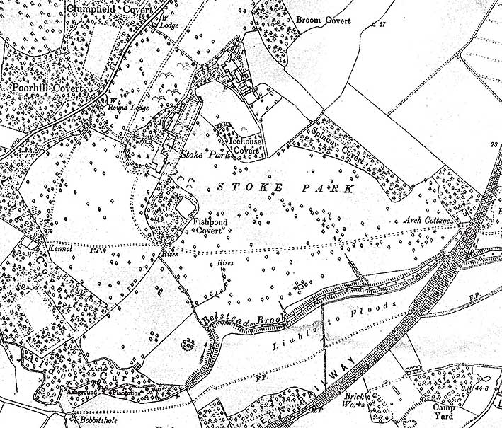
Stoke Park in the early 1930s
 Early
1930s map
Early
1930s map
The above map from the early 1930s shows the location of the
house and parkland in relation to the Ipswich-London main line at lower
right. Arch Cottage is clearly shown at mid-right with the main
carriage-drive (later Corporation Avene across Bourne Park) running
westwards and curving round Fishpond Covert to reach the mansion. The
wavy road at upper left is on the line of today's Fountains Road.
'Round House' on the earlier map (shown above) is here named 'Round
Lodge'. The Grade II
Listing text reads: 'Round Lodge, Lodge to
Stoke Hall (demolished). c1820. Roughcast and whitewashed brick;
thatched roof. Circular plan. One storey. NE side with a timber
verandah supported on cast-iron compound lattice piers. Wide eaves
under conical roof with a central hexagonal chimney. Pointed-arched
doorway to south, externally planked, internally with intersecting
Y-tracery. Four 2-light Y-traceried casements at intervals round
circumference, that to south-west replaced C20. Interior: dished
plastered ceiling. Central fireplace and free-standing flue.' We haven't been able to view this
building, but assume that it still stands amongst the trees.
The
modern housing developments in this area make it difficult to imagine
the country mansion and its many game-bird coverts and grassland. The
Wherstead 'Brick Works' – source of the Wherstead
Red – is shown at the lower right, south of the railway line.
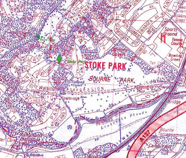
Comparison with 1994 street map
 1930s/1994
comparison maps
1930s/1994
comparison maps
Overlaying the 1930s map (here shown in blue) with the 1994 street map
of the new housing developments (in red) shows the proximity of the
footprint of Stoke Park Mansion to today's Fountains Road. The Mansion
and Round Lodge are shown in green. The carriage
drive matches 'Corporation Avenue' across the modern Bourne Park. Apart
from Belstead Brook and the Great Eastern Railway, the line of Belstead
Road runs diagonally across the upper left corner which can bee seen on
the 1930s map. The dramatic colonisation of open farm and woodland for
later housing is notable. Part of Wherstead
Brick Works lies under the
modern A137 and part under today's artificial ski slope.
[UPDATE 19.1.2022: ‘I was
reading with interest the history of Stoke Park. I guess many people
might know this but wanted to share with you my recollections of Stoke
Park in 1968. Our family moved into Byland Close, which was the last
street that existed in this new housing estate – so before Stoke Park
Drive / Fountains Road etc.
We children used to love exploring the woods that still existed beyond
our close. Probably where Lanercost Way§ is today, there was
a small,
derelict house with green houses and a sunken garden. It was
quiet small inside the house and we thought it was haunted.
Further along, approaching What is now Fountains Road, I recall finding
a couple of gravestone for dogs. Then where Fountains rRad is, I recall
the beautiful Stoke Park house that had been owned by Peter Burrell.
There were still elements of a formal garden that was overgrown but you
could still see roses dotted about. I think some of the home owners
came and dug up remaining plants for their new gardens. As a child I
was sad that it had to be knocked down and regret I did not take any
photos. I wonder if anyone knows anything about the cottage we found
and its history.
I finally recall the fishpond that had to be drained and ground pump
before they built the Scout and Church building. Best regards, Richard
Arthur.’ Thanks to Richard for these
recollections from his childhood – always valuable in local history. If
vsitors to this website have anything to add, please click 'Contact us'
at the foot of this page.]
§Lanercost Way: see Street name derivations.
Disambiguation (in the
terminology
of Wikipedia)
1. 'Stoke Park', while being the name of the parkland, is also the name
of the Burrell mansion – here we call it
'Stoke Park Mansion' to make it clear. It has been demolished.
2. 'Stoke Hall', built on the rise of
Stoke Hill and next to St Mary-At-Stoke
Church, was built by Thomas Cartwright in 1744/45 ans was once the
home of Robert James Ransome (1830-1891). It has been demolished.
3. 'The People's Hall' in Stoke Street,
close to The Old Bell Inn, has confusingly
had the name 'Stoke Hall' added to its fabric. It still stands.
Stoke
Park Wood Local Nature Reserve
Opposite the Stoke Park Drive entrance to Bourne Park
is a small
nature reserve.
Now an area of woodland, scrub &
wildflower grassland, it had originally been the location of Stoke Park
Mansion. Although an earlier house had existed here, the last mansion
was built in 1838 by Peter Burrell. In the early 20th century this
estate was twice subject to death duties and these events and the lack
of an immediate heir may have been the primary reasons why the estate
was broken up.*** The mansion was demolished in the 1920s, & no
trace of it now remains.
 2016 image
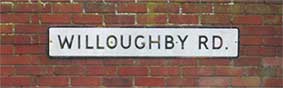
Willoughby Road commemorates the son of Peter Burrell, later Lord
Gwydyr; Burrell supervised
the layout of the roads east of the railway station.
[***To get an idea of the size of the estate: 'The first death
was that
of the near centenarian “Peter Robert Lord Gwydyr who died on the 3rd
April 1909”. He was born 27th April 1810 and inherited the estate on
the death of his father in 1848 “nearly a quarter of a century before
he succeeded to the peerage, on the death of his cousin, in 1870”. He
is credited with the transformation of Stoke. “During the 60 years (or
thereabouts) Baron Gwydyr held the Stoke Park estate the whole district
has been literally transformed ... First he undertook the rebuilding of
the mansion and the remodelling of the really charming gardens and
grounds, this involving expenditure of about £60,000”. Also “the
opening of two fine roads leading to the Railway Station – Willoughby
Road [see above image] and Burrell Road – were due to his initiative”.
“This estate,
which lies just above the Railway Station, has now been partially
covered with residences abutting upon roads called Ancaster, Gesteven
and Gippeswyk – names which blend the ancient titles of the family with
ancient Ipswich” (ref. Obituary East Anglian Daily Times 5th April
1909). His successor was Willoughby Merrik William Campbell Burrell the
last Baron Gwydyr who died without an heir on 13th April 1915. His
mother had been Sophia Campbell whose father had owned Birkfield Lodge.
Following the death of the last baron Gwydyr the estate was offered for
sale on 4th July 1918 “By Order of the late Lord Gwydyr’s Executrix”.
Apart from the park of 300 acres, the lands included Mill House,
Belstead, Stone Lodge in Stoke, Gippeswyk Hall, and six farms; The
Home, Maiden Hall, Gippeswyk, Hill House in Sproughton, Gusford Hall,
and Crane Hill. This site was offered for sale as part of Lot 1 the
“Freehold and small part Copyhold Residential and Sporting Estate
distinguished as Stoke Park ... comprising of A Noble Mansion Standing
in a Beautifully Timbered Park ...']
 The nature reserve sign
The sign reads:
'HISTORY OF THE AREA
Stoke Park Wood Local Nature Reserve was once part of the much more
extensive Stoke Park Estate, centred around the mansion, which was
located about 150 metres to the North of this sign.
The wooded part of the Reserve was formerly known as "Fishpond Covert"
which reveals its function for the estate. The large fish stock pond
(now lost beneath Stoke Park Drive, St Peter's Church and the Scout
Hut) would have provided fresh fish for the house. The covert (planted
woodland) was designed specifically to provide shelter and ideal food
for pheasants and other game birds, again providing a source of fresh
food. This area could be seen as a 'living larder' for the house!
Corporation Avenue, which runs across Bourne Park, follows the route of
the main drive to the old house and continues across this Reserve as
the main path. The trees along the Avenue were planted in 1927 at the
opening of the Park. Bourne Park itself was given to the people of
Ipswich by Alderman (Councillor) William Paul to meet the increasing
need for space for recreation.'
The funeral of Peter Robert Burrell, 4th Lord Gwydyr
 1909
image courtesy Jean Austin
1909
image courtesy Jean Austin
[UPDATE 20.3.2020: Jean Austin
has sent this information along with the above marvellous photograph of
Lord Gwydyr's funeral in 1909.
'Peter Robert Burrell, 4th Baron Gwydyr (24 March 1810- 3 April 1909)
was High Sheriff of Suffolk in 1858. In addition, he was Secretary to
the Lord Great Chamberlain, High Steward of Ipswich, and Chairman of
Quarter Sessions, Suffolk. He succeeded to the title of 4th Baron
Gwydyr, of Gwydyr, County Carnarvon in 1870. He was born at Langley
Park, Beckenham, the son of Lindsey Merrik Peter Burrell and Frances
Daniell, and the grandson of Sir Peter Burrell, 1st Baron Gwydyr.
He married Sophia Campbell in Stoke in 1840, and they had one son, Sir
Willoughby Merrik Campbell Burrell, 5th Baron Gywdyr (1841–1915).
He later married Georgina Holford in Gloucestershire in 1856 and they
had one daughter, Hon. Cicely Burrell (born 1858).
Before his death, Lord Gwyder was the oldest living member of the
peerage.
Peter Robert Burrell, 4th Lord Gwydyr of Gwyder in the County of
Carnarvon and of Stoke Park in the County of Suffolk, died 3 April
1909, within three weeks of entering his 100th year. The picture
(from a postcard) is of the funeral of Lord Gwydyr at Belstead.']
Bourne
Bridge
Close to the Bourne Park entrance is the original Bourne Bridge, now
by-passed and only open to pedestrian and cycle traffic. Mike O'Donovan
writes (3
April 2011): "You may find the attached photo of interest. It's of a
plaque on Bourne Bridge. The words are now very weather worn, and it's
another interesting item of Ipswich history. The inscription reads:
BOROUGH
COUNTY
OF
OF
IPSWICH
SUFFOLK
BRIDGE WIDENED 1891
BY THE COUNTY AND BOROUGH AND BY
PRIVATE SUBSCRIPTION
OPENED OCT 29 BY
ALDERMAN NATHANIEL CATCHPOLE
ALDERMAN OF JOINT COMMITTEE"
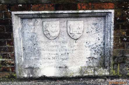 2011 photograph
courtesy:
Mike
O'Donovan
2011 photograph
courtesy:
Mike
O'Donovan
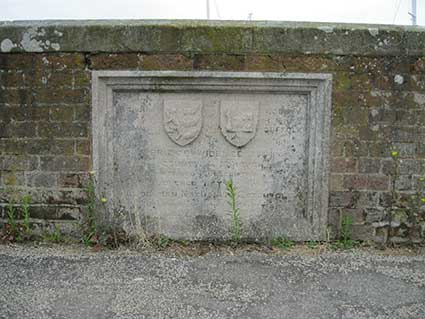
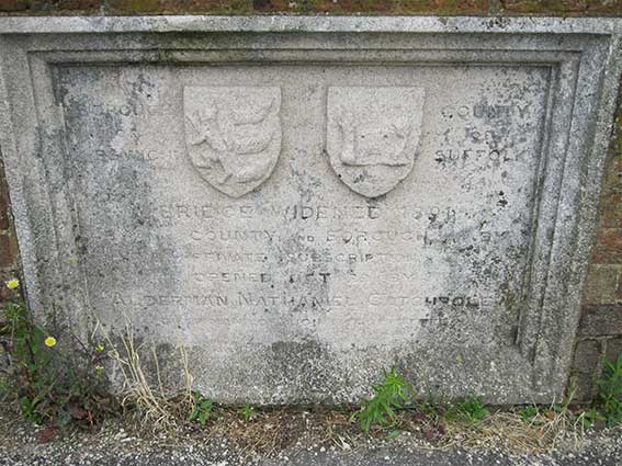 2016 images
The 1891 stonework is eroding but is still just about readable; the
shields bear the arms of the town (lion
rampant and three ships' sterns) and the castle seen on County Hall where it surmounts a scroll
bearing the word 'SUFFOLK'.
'BOROUGH
OF
IPSWICH
COUNTY
OF
SUFFOLK
STOKE BRIDGE WIDENED 1891
IN THE COUNTY AND BOROUGH, BY
PRIVATE SUBSCRIPTION
OPENED OCT 29 BY
ALDERMAN NATHANIEL CATCHPOLE
CHAIRMAN OF JOINT ‘COMMITTEE’
Following the enactment of the
Local Government Act 1888 the County Borough of Ipswich was created
with the rest of Suffolk being divided into the administrative counties
of East and West Suffolk. The County Borough of Ipswich had as its
first mayor Nathaniel Catchpole (1889-1890). He has a portrait painted
by Frederick George Cotman (1850–1920) which is in the Ipswich Museums
collection and which can be seen on the Art
UK website. Nathaniel Catchpole is prominently commemorated on one
of the plaques on Tooley's Almshouses.
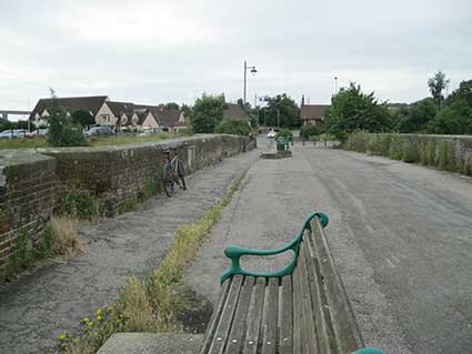
Above: the old Bourne Bridge with its rectangular and trianglar niches
(four of each) viewed from
the Wherstead Road end – the 1891
stone tablet can be seen just past the compiler's bicycle in the left
wall. In the
background, centre left, is The Ostrich public house (see below).
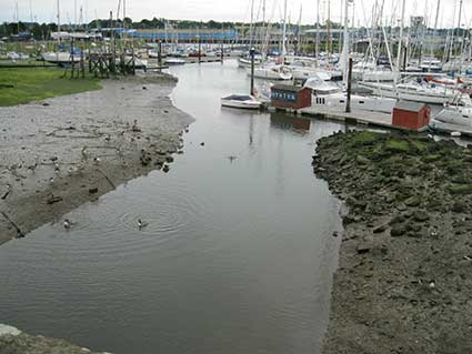
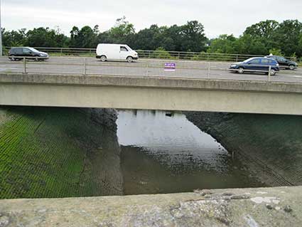
Above: the views from one of the niches in the bridge over the Bourne
River where it joins the River Orwell (labelled 'Ostrich
Creek' on some maps) with Canada Geese in the
foreground;
in the opposite direction the
rather more brutalist, canalised Bourne River fed by Belstead Brook
beneath the southern, dualled
part of
Wherstead Road; this concrete bridge replaced the old Bourne Bridge (in
the 1980s?).
Ostrich Terrace, 568-574 Wherstead Road
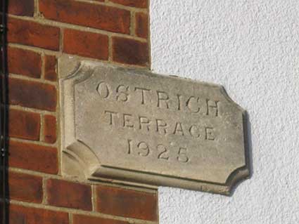
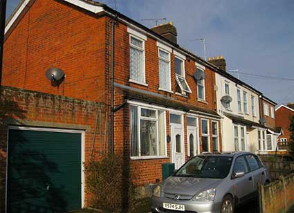 2016 images
'OSTRICH
TERRACE
1925'
on the four houses facing the
Bourne End Convenience Store echoes the 'original' name of the
Wherstead public house across the old bridge.
See also our Bostock Road page for
nearby interestingly named houses.
The Ostrich public house
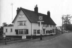 1963
photograph
1963
photograph
Bourne bridge marks the boundary of Wherstead
parish. Near the bridge, on the Wherstead side, stands the
Ostrich Inn, as it stood at the time of the New England
migration. In those days, however, oysters were still found in
Orwell waters, and the name 'Oyster Ridge' had not been corrupted to
the name of the exotic bird whose effigy for many years adorned the
swinging signboard of the roadside tavern. It's instructive that when
this pub was bought and greatly extended in the nineteen nineties it
was renamed 'The Oyster Reach'.
Another source suggests:
"Ipswich, the county Town of Suffolk, and the Port
itself, is spread out with the Ostrich public house by Bourne Bridge
marking the boundary. The Ostrich is four centuries old and named
after part of the crest of the Earls of Leicester who once owned the
land on which is stands. It is also said the name ~Ostrich~ was a
mistake caused by a drunken landlord whose slurred speech resulted in
the sign writer mis-understanding his orders for the sign to be painted
~The Oyster Reach."
The oldest part of the pub (adjacent to Bourne Hill) dates from the
16th or 17th century, though it has been much altered and added to.
According to Alfred Hedges' book, "Inns and Inn Signs of Norfolk and
Suffolk", the inn has been in existence since 1612. 'The Ostrich' is
Listed Grade II, despite some heavy modern additions and alterations.
[UPDATE 16.9.2015: 'The Ostrich
at Bourne Bridge, WAS a corruption of Oyster Reach (try saying it in a
heavy Suffolk accent) as there were for many years oyster beds in this
area. 'Reach' meant an area of foreshore. My grandfather lived in the
cottages opposite the pub in the 1940s as a cowman, tending a herd on
the fields at Bourne Hill.
Unknowingly, in the 60s and 70s, I spent many summer holidays close
by, down at 'the basin' on Bourne Bridge, before it was filled in, it
was the summer meeting place (our private swimming pool – ha ha –
depending on the tide) for many of the children from Maidenhall, who
accessed it from the tracks at the ends of Halifax Road and Conway
Close that led through to Wherstead Rd and Bourne Park.
Hope this is of interest. Well done with the website. Mike.' Thanks, Mike. The tracks you mention are
close to the small, numbered rail bridge over the pedestrian way down
to Wherstead Road on our Rail bridges
page.]
More park lettering: Alexandra Park, Christchurch
Park (and Mansion) and Chantry Park.
See also our Lettered castings
index page.
Home
Please email any comments
and contributions by clicking here.
Search Ipswich
Historic Lettering
©2004
Copyright
throughout the Ipswich
Historic Lettering site: Borin Van Loon
No reproduction of text or images without express written permission