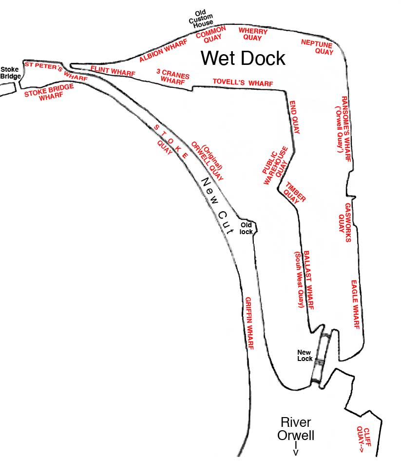
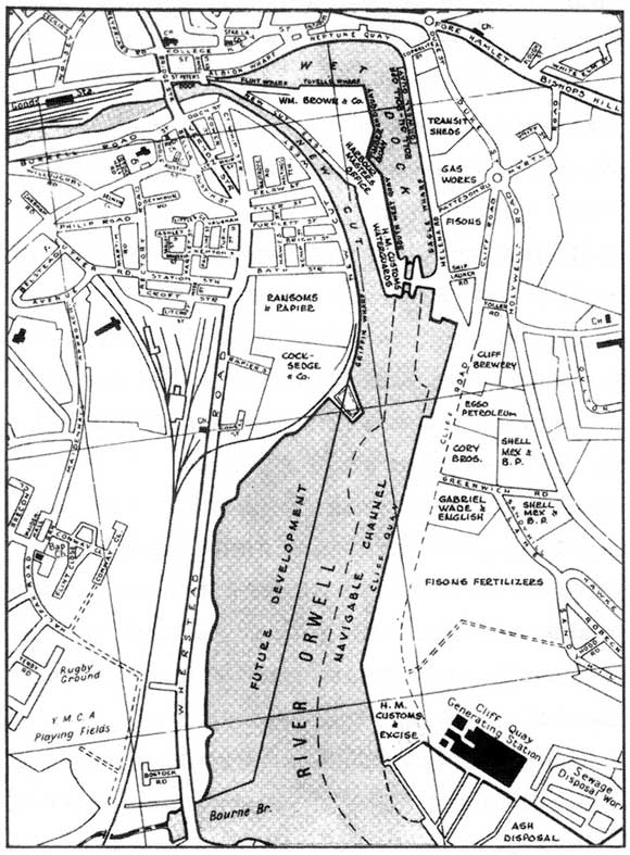
 Wandering
around the Ipswich docks over
the
years, as so many residents must do, we've often been puzzled about the
names of the wharves and quays and quite where one begins and another
ends. The map here is an initial attempt to insert the names used at
various times and attach them to various parts of the dock and River
Orwell. We hope it is of some interest and we welcome comments and
additions, stories and anecdotes: see bottom of this page for a link.
Talking of which...
Wandering
around the Ipswich docks over
the
years, as so many residents must do, we've often been puzzled about the
names of the wharves and quays and quite where one begins and another
ends. The map here is an initial attempt to insert the names used at
various times and attach them to various parts of the dock and River
Orwell. We hope it is of some interest and we welcome comments and
additions, stories and anecdotes: see bottom of this page for a link.
Talking of which..."To find the old names you need the little maps that used to be issued by the Ipswich Dock Commission with their annual reports [see reproduction below]; they show many of the old names - of which Tovell's Wharf is not one. Tovell's Wharf was constructed in the 1920s when the old 'branch dock' was filled in - it had originally been a timber pond for the storage of imported timber. The new wharf was named after George Tovell, a member of the Ipswich Dock Commission in the early days; he had a cement works in the area on which the wharf was built. By the way, you have misplaced it on your map, putting it at South West Quay; Tovell's Wharf is where you have the word 'Quay', opposite the Custom House. There are also large-scale OS plans at 50 inches to a mile in the Suffolk Record Office; the first edition, 1882 or thereabouts, and the second of the early 1900s will give you all the names." We're grateful for the assistance in (May 2011) of Bob Malster, a proper local historian, and his interest in the website.
Stuart and Des of the Ipswich Maritime Trust have contributed two maps:
"You will see from Stuart's plan that St Peters Wharf is actually in the New Cut right by Stoke Bridge; at one time the water was wider there But the area at the head of the dock was widened to take another railway line." We naively assumed that St Peter's Quay was the part of the Wet Dock which ends in the 'nip' at the west end, i.e. adjacent to St Peter's Church. We also note that 'Common Quay' shown on some maps as stretching along the northern section of the dock became a shorter quay around the Old Customs House, part of it replaced by 'Neptune Quay', perhaps.
Those in the know will spot that the adjacent map is a summary or compromise which attempts to show the names and positions used over time since the Ipswich Wet Dock lock gates were first opened on 17 January 1842. This date is taken from the invaluable book 'A Victorian vision: the building of Ipswich Wet Dock' by Bob Malster and Bob Jones (see Reading List). The southern lock used today officially opened on 27 July 1881.
An example of the way in which wharf and quay names change over time is provided in Twinch, C.: 'Street by street Ipswich' (see Reading list).
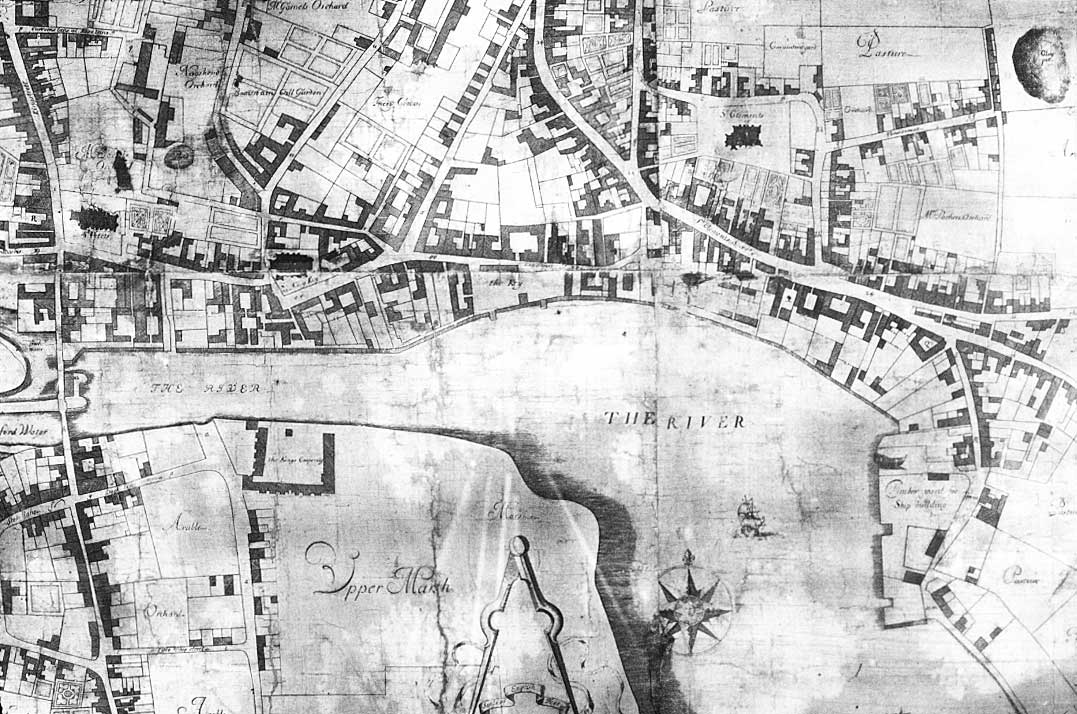
"The Common Quay, formerly Key or Cay, was also known as the Old Quay and is one of the three small quays of medieval Ipswich – the Common Quay, Bigod's Quay and one owned by the Harney family. The wharves of Common Quay (part of which is now encompassed by Neptune Quay) were known as St Peter's and the Albion. Dr Taylor's description of this important part of the waterfront in 1888 cannot be bettered: 'A few years ago the site of the [Common] dock was the junction of the Gipping and the Orwell – before the 'new cut' was made, and the upper reach of the Orwell estuary imprisoned to form a dock. The river then came directly up to the warehouses. Some of the latter are very ancient, and are now being pulled down or modernised.'* "
(*Dr J.E. Taylor: In and about ancient Ipswich. 1888)
[UPDATE Sept. 2011: The Ipswich Maritime Trust (partially as a result of an enquiry about wharf names from this website) has produced an excellent 'IMT Occasional Paper No. 1: Quays and wharves of Ipswich' which attempts a 'definitive' map of the names: very difficult as they changed and moved over time with custom and developments in the industrial activity around the Wet Dock. We have updated the map here from that document and thank the IMT for its research (also the excellent illustrations in the occasional paper). One controversial inclusion is the placing of 'Orwell Quay' on the east bank of New Cut, whereas people currently believe the stretch of quay which was 'Ransome's Wharf' at the time of their engineering works on the east side of the Wet Dock to be 'Orwell Quay'. Bob Malster's research has uncovered other names, too. It all highlights the rich history of maritime activity in Ipswich.]
Note that Ipswich marks the confluence of the River Orwell and the River Gipping. The actual changeover point, where the freshwater Gipping meets the brackish Orwell is near Handford Bridge to the west of the town at Horseshoe Weir. See our page on Water in Ipswich for further information on these rivers.
Definitions: A wharf, quay, or staith(e) is a structure on the shore of a harbour or on the bank of a river or canal where ships may dock to load and unload cargo or passengers. Such a structure includes one or more berths (mooring locations), and may also include piers, warehouses, or other facilities necessary for handling the ships. Wharves are often considered to be a series of docks at which boats are stationed.
[UPDATE 5.2.2021: 'Historic Quay and Wharf Nameplates – For many years we have been keen to see the historic quay and wharf names re-instated, rather than see developers choose their own names, which have often been irrelevant to the history of the Wet Dock. This year we were successful, and we have worked closely with Ipswich Borough Council to have several street nameplates installed along the waterfront, including Albion Wharf, Wherry Quay and Neptune Quay. We are also working closely with the Ipswich Society to add informal nameplates to even older quays such as Common Quay, which cannot be formally recognised by Ipswich Borough Council as they pre-date the modern postal code system. To find out more about the Historic Quays and Wharves do check out our Occasional Paper on the subject [link shown above].' This passage and photograph come from the Ipswich Maritime Trust website (see Links).
Below: IMT Chair Geoffrey Dyball and Ipswich Borough Councillor Phil Smart with one of the new nameplates for Wherry Quay.
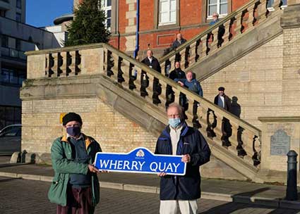 Photograph
courtesy Ipswich Maritime Trust
Photograph
courtesy Ipswich Maritime TrustSee our new page on the blue quay nameplates: 'St. Peters Wharf', 'New Cut East, Private Road', 'Albion Quay', 'Wherry Quay/Neptune Quay', 'Neptune Quay', 'Patteson Road', 'Helena Road', 'Ship Launch Road'.
1930 map
[UPDATE August 2012: Gordon Pugh has sent an image of an Ipswich map of c.1930 which gives another view of the evolving Wet Dock. The 'Branch Dock' mentioned by Bob Malster is clearly shown, also the 'Public Warehouse' which still stands, sans lettering, in the 21st century (see our Island page).]
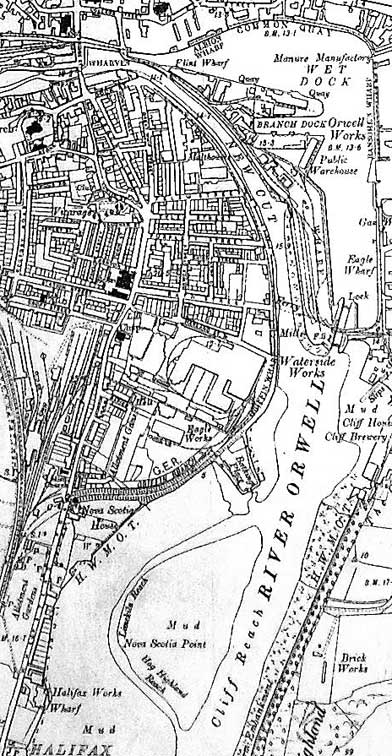 1930 map of Orwell and Wet Dock
This map clearly shows the Stoke Bathing Place, a walled-off area for Ipswich Swimming Club on the West Bank, now part of the container depot. Further south is Captain Richard Hall Gower's Nova Scotia House (Gower Street is shown on our Felaw Street page), home of the Nova Scotia shipyard (with the 'Nova Scotia Point' mudbank in the river). Further south again is 'Halifax Works Wharf' marking the site of the Halifax shipyard. Both these very un-Suffolk names were used to describe their surrounding areas (see also 'Greenwich', named after the farm over the river to the west of both shipyards), somewhat to the mystification of the present-day inhabitant. For more on Halifax see our page on 'The Whaling Station'. One tiny feature, easily overlooked, is the 'Ferry' labelled on a dotted line across New Cut between The Griffin Inn atthe end of Bath Street and the Island; presumably one could walk down to Stoke Quay from Over Stoke, get the Griffin Ferry onto the former Promenade where the Umbrella shelter once stood, across the small spit of land, over the swing bridge on the lock and onto Ship Launch Road, Cliff Road and Cliff Quay.
See our Ransome's site page for an 1867 map detail of the east bank of the Wet Dock.
See also our Chantry Park page for a map of the Wet Dock and River Orwell from the Souvenir of the Royal Show, 1934.
Tramway and rail map of the Wet Dock showing stages of expansion
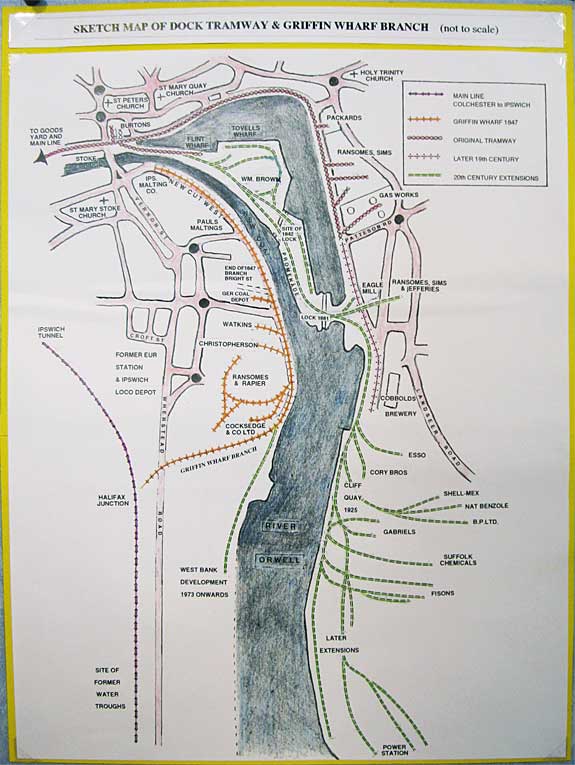 Map by
the Over Stoke History Group
Map by
the Over Stoke History GroupThe above, undated, map shows the height of industrial rail transport around the Wet Dock:-
- The original tramway appears (in red) at the top left, crosses Bridge Street and splits (just before the junction is a spur serving the Burton factory): a branch going up St Peter's Wharf and a short way onto the Island site, the main tramway following the northern quays having a spur to Packard's Manure Factory, three spurs to Ransomes Sims & Jeffries engineering works and a longer spur to the Coal-fired gasworks just north of Patteson Road.
- The tramway was extended (shown in red) in the later 19th century southwards to Cobbold's Brewery on The Cliff.
- Further extensive expansion of the tramway in the 20th century (shown in green) occurred not from the brewery, but from the Island site. This was presumably to avoid congestion on the northern and eastern quays of the Wet Dock – a very busy area for shipping, unloading, loading and transporting goods by horse-and cart, not to mention pedestrians. The tramway lines, still visible on the Island site in 2019, extend past the spurs to the William Brown timber yards and split into a branch running down Timber Quay and Ballast Wharf (to the right of the Island) and all the way down the site of the old Promenade; this then runs over the southern lock via the Ransomes & Rapier swing-bridge to run beside the earlier tramway. It continues beyond the brewery to Cliff Quay (developed in 1925) with multiple spurs serving a number of modern industrial companies including Fisons, terminating at the Cliff Quay coal-fired power station (demolished in 1994).
- The Griffin Wharf branch of the railway leaves the main line (and sidings) at Halifax junction (constructed in 1847), south of the tunnel through Stoke Hill. It crosses Wherstead Road via 'the Black Bridge', as it was known to many locals (see our Felaw Street page for a 1959 photograph of a train on that bridge), running parallel with Cowell Street (not shown here) and curving northwards. Photographs of the tramway in 2014 at the end of Bath Road can be found on our Felaw Street page. Freight trains then reverse into the West Bank Terminal (built from 1973 onwards – this section of the line shown in green); this continues to be used fortnightly in 2019. However, far from stopping there, it is clear from the map that in 1847 the orange-brown coloured line went northwards all the way along New Cut West to:
– R&W Paul's Stoke maltings (now widely known as 'Felaw Street Maltings', an office complex) on the junction of Felaw Street and Stoke Quay,
– with spurs serving the Great Eastern Railway coal depot on the corner of Bath Street and Stoke Quay,
– Eldred Watkins (cement and lime works),
– W. Christopherson Ltd (cattle food and corn merchants), Watkins and the GER (Great Eastern Railway) coal depot,
– Ransome & Rapier Ltd (engineering – see much more on our Bourne Park page),
– Cocksedge & Co. Ltd (engineering – see the cast bollard on our Dock ground level page),
A tramway is a set of rails laid in the surface of a road, rather than being raised on sleepers and a clinker bed. Although customarily used by tramcars in towns and cities in Victorian and Edwardian times (trams having had something of a rebirth in the late 20th century), these tramway lines have also been used by horse-drawn, steam and diesel vehicles particularly for the moving of freight wagons – exactly as we see around the Wet Dock and beyond.
For remnants of the tramways around the Wet Dock see our Island and Dock ground level pages also our Felaw Street page for the Griffin Wharf Branch.
1973 map
 1973 map
The above map captures the Wet Dock area when trade and industry were thriving in 1973. The West Bank Terminal has yet to be built (the Stoke Bathing Place can still be seen below Griffin Wharf) and ownership of business premises is labelled.
1994 diagram
 1994 diagram
The above annotated aerial photograph of the Wet Dock and New Cut has been taken from the book The Port of Ipswich published in 1994 by Ipswich Port Authority. At this date the Wet Dock is seen as a more-or-less post-industrial area with one or two of the giant concrete silos active, a ship moored at Three Cranes Wharf/Tovells Wharf and very few leisure craft. The modernisation of Vernon Street and Hawes Street (by-passing Wherstead Road) can be seen at lower left with the two new roundabouts in place and just above right, Felaw Street with the restored Felaw Maltings and The Steamboat Tavern nearby. Comparing this image with the dock map in the book, we find that south of the 'Orwell Quay' at No. 5 no mention is made of Gasworks Quay, Eagle Wharf or on the opposite side of the River Orwell, Griffin Wharf. It is good to find that The Harbour Master's Office is labelled, a building which has been abandoned for many years as far as we can see. Bob Jones (co-author of the book A Victorian Vision on the Wet Dock, see Reading List) has uploaded an photograph of the structure with a note that he was the Personnel Officer working from the building (1979 - 2000).
1884 map
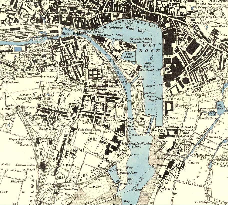 1884 map
The above detail is taken from the map surveyed in 1882 and published in 1884 available on the excellent NLS map project website (see Links under 'Specialist subject areas', then 'Maps'). At this time both locks into the Wet Dock are visible (the southern lock opened on 27 July 1881), but the one which opened into New Cut was used less and less, eventually to be filled in. The lock gates at the New Cut end are labelled 'Foot Bridge', so that ladies and gentlemen who wished to walk the Promenade to sit under 'The Umbrella' shelter next to the Pegasus statue with views over Stoke Bathing Place on the west bank, and The Cliff and Hog Highland on the east bank had to negotiate this narrow right of way.
The Griffin and the tramway
However, some might take the 'Griffin Ferry' from the end of Bath Street to the south of the Promenade. The Griffin branch tramway crosses over the route to the foot ferry and stretches up to the end of Bright Street. So why 'Griffin'? The Griffin Inn (named after the mythical creature, half-eagle and half-lion) was at 160 New Cut West, on the corner with Bath Street; active in the Victorian industrial heyday, the pub closed in 1951. Inevitably, given its position opposite the Cliff Brewery, it was a Tolly Cobbold house. It was demolished to make way for an extension to the Ransomes & Rapier Waterside Works (incidentally, the works features an oval tramway which doesn't link to the network – puzzling). In 2018 the Griffin site is right next to the Tidal Barrier which is designed to protect many low-lying properties upriver from combinations of high tides, winds and rainfall. The Island tramway extends from St Peter's Wharf along the isthmus to the northern part of the Island; the upper lock prevents its extension south to the new lock, over which a Ransomes & Rapier swing bridge was eventually built to carry rail traffic over the lock and on to Cliff Quay. 'St Clement's Ship Yard' is clearly shown with its slipway into the river. It is where the Sailing Barge Victor was built, a vessel which, in the 21st century, has a new life for pleasure cruises and parties.
Features on the map
Interesting little features can be spotted on this 1884 map. A 'Manure Works', processing coprolites and phosphate-rich nodules as fertiliser, stands south of The Griffin when most people know only of Edward Packard's Manure Factory across the dock on Coprolite Street. Further south is Nova Scotia House, former home of naval architect Richard Gower. We also note another pub, The Lock Tavern, on the Island site, close to 'The Basin'. Closed in 1955, it was converted into flats, then later demolished. The view across New Cut from the tavern would be the gardens and grid-like buildings of the Ipswich Union Workhouse in Great Whip Street. The 1880 Public Warehouse is clearly marked on the Island and still stands today. Looking west, streets running down to New Cut West which have disappeared are Bright Street and Harland Street with Kemp Street crossing the former. Hawes Street is running north-south at this time linking Harland Street and Felaw Street: quite a narrow thoroughfare which was to become the main traffic route linking a widened Vernon Street with the lower part of Whertsead Road. Station Street stops at the undeveloped Rectory Road (which ran to the rectory of St Mary-At-Stoke Church, which is now part of the Maidenhall development); Luther Road does not exist. St Peter's Vicarage is clearly visible off Austin Street.
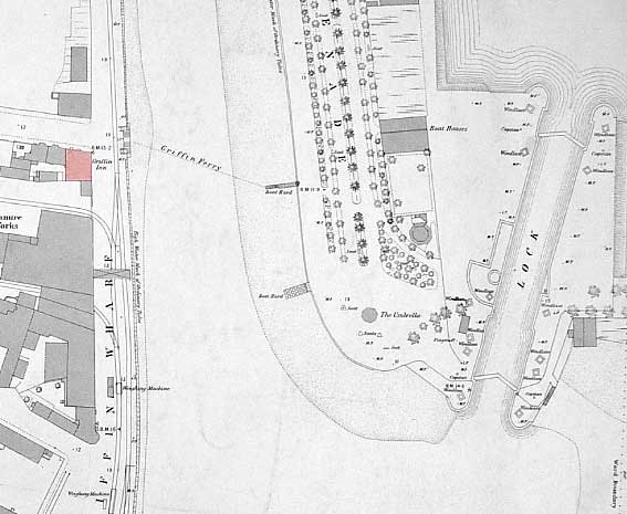 1884
map detail
1884
map detailThe above map detail shows the 'Griffin Ferry' running between a 'Boat Hard' on the Island, close to the southern part of The Promenade and the quay next to the Griffin Inn (shown here in red) on the southern corner of Bath Street and New Cut West. One assumes that Victorians and Edwardians in particular might stroll up and down the avenues of trees, sit under 'The Umbrella' (to the south, labelled on the map), then take the Griffin Ferry across to New Cut West. Whether the Griffin Inn was salubrious enough for a small libation to round off the constitutional is a matter of conjecture.
Ipswich Dock Act 1805 map: PLAN of the Proposed Improvement of the RIVER ORWELL, from Ipswich to Freston Reach Sep. 20 1804.
[UPDATE 25.11.2013: Peter Turtill has sent this map covering the point of the Handford Road bridge at the left down to the Orwell to Downham Reach below Freston Tower (marked lower right), almost forty years before the Wet Dock was built.]
The river and town turned on its side is difficult to decipher, so we have reorientated the future Wet Dock area below. The navigable channel is delineated in the middle of the river with its named reaches (Pigeon Locker Shoal, Cliff Reach, Lime Kiln Reach, Hog Island – known to many as 'Hog Highland' – Reach etc.) in 1804 when the map was drawn. Proposed newly cut shipping channels are clearly marked. Bourne Bridge Creek is the vertical inlet in the lower centre with, to its left 'Halifax Ship Yard' and, further left, 'Nova Scotia' (Shipyard), both off Wherstead Road. Around the town end of the river are places labelled 'Embanked Marsh' and they give some sense of the problematic, low-lying land hereabouts from before Anglo Saxon times, which hindered develoment until drainage schemes helped to make the land passable later in the century. We have already seen the problems faced by builders in the Alderman Road area when the Tramway power station was built and St Mary-At-Quay church still suffers from the ooze upon which it was built. Reference has also been made to the 'Corporation Marshes' overlooked by Thomas Cartwright's Stoke Hall and the nearby church. It is perhaps significant that a large, low-lying section of what we now call 'Over Stoke' to the west of Wherstead Road is labelled as 'Embanked Marsh', which would explain why Stoke remained as a small village until the industrial revolution. It is not a surprise to the present day inhabitant of Ipswich that the road leading from The Ostrich down Freston foreshore is labelled: 'The Water frequently in the Spring Tides flows up to This Road'. Similarly the shoreline between Greenwich Farm and Downham Reach Farm is labelled: 'Gravelly Beach covered only in extraordinary Spring Tides'.
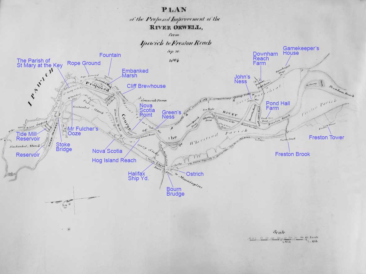
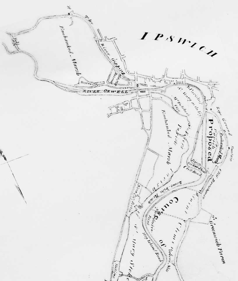
Swivelling the Wet Dock detail of the map clockwise (below) is helpful as it places it in the customary orientation. It is notable that in 1804 the River Orwell was considered to flow from the west to Stoke Bridge (what we now call The Gipping) and 'The River Gipping' looped over from the north to join it near the 'Tide Mill Reservoir'. The principle so clearly demonstrated by Woodbridge Tide Mill, only a few miles away from Ipswich, relies on trapping the tidal waters in a large mill pool using sluices. The miller then had a reserve of power to drive the mill using gravity once the tide had receded. With drainage and river redirection and canalisation in more recent times we now consider that The Gipping (fresh water) meets The Orwell (brackish or salt water) at a point roughly west of Stoke Bridge. The characteristic Wet Dock right-angled shape is here seen in its open form with successive revetments built for unloading and loading ships raising and flattening out what had been marshy ground. In 1804 the south west of the dock is still labelled 'Mr Fulcher's Ooze'; this gives an indication that the area would have looked very different then. One wonders what benefit Mr Fulcher got from ownership of his ooze; perhaps he hung onto it until selling it for redevelopment of New Cut and The Island site created in 1842.
See also Davy's illustration of the laying of the Wet Dock lock foundation stone, 1839.
Ogilby’s dock map of 1674
 1674
map
1674
mapThis section of Ogilby's 1674 map shows the 'natural' dock with revetments forming the northern and eastern quays and shipyards and with marshland over a large part of the south and west. Our Felaw Street page includes a close-up of the Great Whip Street crossing from this source.
Related pages:
The Question Mark
Christie's warehouse
Bridge Street
Burton Son & Sanders / Paul's
College Street
Coprolite Street
Cranfield's Flour Mill
Custom House
Trinity House buoy
Edward Fison Ltd
Ground-level dockside furniture on: 'The island', the northern quays and Ransome's Orwell Works
Ipswich Whaling Station?
Isaac Lord
Neptune Inn clock, garden and interior
Isaac Lord 2
The Island
John Good and Sons
Merchant seamen's memorial
The Mill
Nova Scotia House
New Cut East
Quay nameplates
R&W Paul malting company
Ransomes
Steam Packet Hotel
Stoke Bridge(s)
Waterfront Regeneration Scheme
Wolsey's Gate
A chance to compare Wet Dock 1970s with 2004
Davy's illustration of the laying of the Wet Dock lock foundation stone, 1839
Outside the Wet Dock
©2004 Copyright throughout the Ipswich Historic Lettering site: Borin Van Loon
No reproduction of text or images without express written permission