and
the hidden river
An example of a most historic and significant place in the story of Ipswich, which is today a forgotten, tiny dog-leg of road... a dead end.
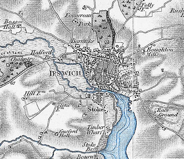
The map of 1902 shows that it once was much longer. Friars Bridge Road (the map legend elides the first two words) can be seen running east-west at the upper left of the map detail with 'Cattle Pens' to its north and 'New Cattle Market' to its south, before it meets Portman Road.
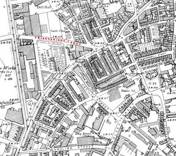 1902
map detail
1902
map detailThe modern sketch map of the area (below) shows the triangular block of buildings to the west of the Princes Street/Civic Drive/Franciscan Way junction (formerly the Greyfriars roundabout) with a remnant of Friars Bridge Road curling round it. Part of the approach road into the car park off Portman Road follows the line of the old Friars Bridge Road. The 'New Cattle Market' south of that road line is also today a car park.
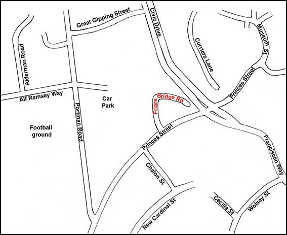 2015 map
See our Civic Drive page for a fuller view of the 1902 road layout with modern streets overlaid.
National Farmers Union Mutual relief
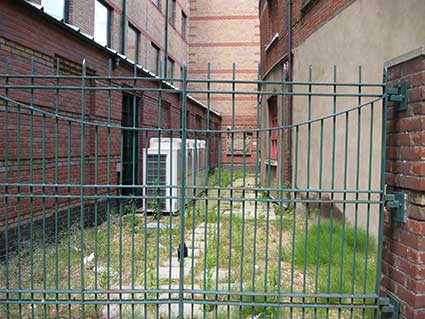
The NFU had offices at 2 Friars Bridge Road, but to the left of Observation Court, 84 Princes St one can see a stone relief panel at the end of the (now gated) courtyard of Legal and General Building, just visible from the street. The Public Sculptures in Norfolk & Suffolk (see Links): 'Two farmers stand on a foreshortened field. One is older and bearded wearing a waistcoat and his younger companion wears a short sleeve-shirt. They hold a stone sign in front of a sheaf of corn decorated with a cow in profile, a foreshortened tractor, pig and four sacks of grain. The wheatsheaf is the symbol of NFU Mutual, the farmers' insurance company, this grander and more complex design must have been commissioned when the Ipswich branch first moved into this building, perhaps in the 1950s. The building was renovated for NFU Mutual around 1993, before they moved to Lower Brook Street when it was taken over by Legal and General.' This work in stone is unattributed and is now almost hidden to the public.
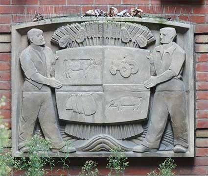
Close-up photograph courtesy Tim Leggett
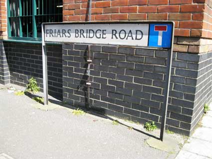
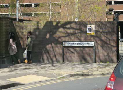
Street nameplates
The street nameplates are of interest in that there are two, where one might have imagined that one would do. Also that one of the signs (below right) is set back on the sharp corner: an area used as a "smokers' ghetto" for workers from the surrounding office blocks.
 2015
images
2015
imagesSee also Coytes Gardens, further up Princes Street towards the Cornhill.
Greyfriars Priory
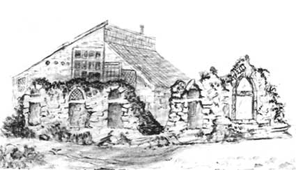
Above: the ruins of Greyfriars, a line-and-wash illustration from G.R. Clarke's History, 1830 (see Reading list). The Greyfriars Priory lay to the west of Greyfriars Road. Surviving arches were moved to Christchurch Park, but when Greyfriars precinct was built in the 1960s these arches, with other remains from Friars Road, were re-erected in the precinct. See our Monasteries page for photographs of the arches. It is unlikely that such treatment would be given to archeological remains today, one hopes. A 1902 map detail of the area showing the site of the remains at that time can be seen on our JBO lost signs page under the 'Before Willis' section. (See also our Monasteries page.)
It does not appear to be so in today's townscape, but Greyfriars Priory was seen as built on a riverside site.
The Little Gipping, Friars Bridge and The Horsewade
The street name indicates that it marked the western boundary of the Franciscan Friary (Greyfriars) which extended south from Friars Street. The Friars Bridge, one of the western approaches to Ipswich, led to the Priory. It sounds contemporary with the religious establishment, but there is likely to have been an older bridge leading to the 'Oldenholme' (possibly the root of 'Alderman') marshes, where the town portmen had pasturage for their horses. The earthen rampart, probably with a pallisade on top, and ditch below it was redug (1203) to defend (and, more importantly, proclaim the status of) the old town in the years after King John granted Ipswich its Charter in 1200 (our Water in Ipswich page covers the ramparts in more detail). The marshland lay outside the medieval defences which follow the outer line of the Anglo-Saxon settlement and the rampart appears to have reached down to a causeway, built above the marsh, from Greyfriars which bridged the Little Gipping River (much of which runs underground in the 21st century) at Friars Bridge. This most probably coincides with the ancient place where horses could ford the river: The Horswade. As Muriel Clegg (Streets and street names in Ipswich see Reading list) writes: "An earlier arm of the [Gipping] river, now underground, approached the town from a more northerly direction and gave a curious impression (reflected in the three maps [John Speed's map of 1610, John Ogilby's map of 1674, Joseph Pennington's map of 1778]) of completing its defensive encirclement just where the medieval rampart ended." On Speed's map this smaller river is labelled 'Orwell Flu.'. A wide area of marshland and a harbour/riverside were as much a defence against attack as a ditch and rampart. Of course, if the rampart was more of a signifier of the boundary of the medieval town, the same would apply.
 pre-1842 map
The above map shows the curious split in the Ipswich rivers west of Stoke Bridge. Note that this is pre-Wet Dock (opened in 1842). On Pennington's map of 1778 the loop running to the north from Stoke tide mill is labelled 'The River Gipping', the suggestion on the map that the southern part of the river is The River Orwell. It is likely that the northern loop of the river was dug (possibly by the Romans) to feed the water-mill: Hegenford or Handford Mil – which would have been sited at the point where the river is closest to Handford Road. (On E. E. White's Map of c.1867 it is labelled 'River Gipping/Orwell'.) There is an apparent spelling error of 'Halford Bridge' at upper left, for Handford Bridge. The whole area to the south and west of Ipswich around the rivers is depicted as extensive marshland: a natural defence to attackers from the west.
John Speed's map 1610
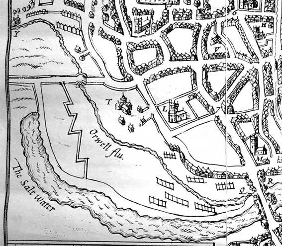 1610
map
1610
mapApart from a few erroFrs in locations and labelling, one interesting feature of the Speed map is the array of shapes resembling railway tracks on the marshes to the east of Stoke Bridge. These are representations of tenter (or 'tainter') frames for stretching wollen cloths. They are testament to the importance of the wool industry and trade to Ipswich at this time.
The wider River Orwell stretching westwards from Stoke Bridge is labelled 'The Salt Water'; the much narrower channel (later called The Little Gipping') to the north is labelled 'Orwell flu'.
'L' on the map indicates the Church of St Nicholas; 'T' is the remnants of Greyfriars Priory 'M' is the Church of St Peter; 'F' is the Church of St Mary Elms; 'Y' (mislabelled on Speed's map) is Handford Mill.
Ogilby's map, 1674
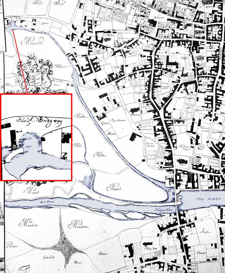 1674 map
This section of Ogilby's 1674 map shows how the Orwell to the east of Stoke Bridge is labelled 'The River'. This wide lagoon, today called St Peter's Dock, spans the site of the original Anglo-Saxon ford with the northern end of Great Whip Street running into the water, its exit being the site of today's Foundry Lane running up towards the Wolsey Gate. On the west side of the bridge, the lower and wider water is labelled 'Hanford Water' (and later 'Salt Water') with 'Fresh Water' in the narrow channel above. This channel was almost certainly dug (perhaps by the Romans) to provide water power to up to three water mills. The detail in a red frame shows the street 'Handford Bridg way' (spelling is a bit varied on Ogilby's map) with the infrastructure and water-wheel of Hagenford's (Handford) Mill.
'Common meadow and marsh
A large area of somewhat marshy ground west of the Gipping belonged to the burgesses in common; the northern part in particular, being drier, was used for pasturage. The common meadow included Portman Meadow, dedicated in 1200 to pasturing the horses of the town councillors; before 1200 and through the 14th century it was known as Odenholm meadow, although by the 1440s it was being called Portman's Meadow. It was accessed via a ford and later by Friars Bridge.
'Horswade Mill
Speed does not reference this on his map, and the location of the mill is not clearly indicated in any medieval record that I have read. However, it was a water-powered mill and is frequently referred to in conjunction with the common meadow/marsh on the west bank of the Gipping – in the 1340s, when the borough was leasing the mill to private citizens, Odenholm meadow was jointly leased out with it; at that time Horswade Mill was said to be in a ruinous state. A deed of 1388 is concerned with a plot of land lying between a (river?) bank connecting Horswade Mill and Stoke Bridge and the road connecting the Barre Gates and Friars Bridge; based on this, on a feature on Speed's map showing otherwise isolated buildings at the end of a side-road leading to the Gipping, and on the evidence from later maps (which show one of those buildings extending to the river's edge), I am tentatively hypothesising that this may represent the mill location, directly across the river from the common meadow. Horswade served as the official place where burgesses were supposed to have their grain ground, judging from a borough lease in 1308 of the (tolls paid at) the mill. It was distinct from the New Mill, another building that was separately leased out by the borough; the leasing of both mills is referred to as early as 1286.
'Friar's Bridge
The name suggests it may have been built contemporary with or shortly after the establishment of the Franciscan friary (although it might have had a different name earlier). The only evident purpose of the bridge was to provide access to the community pasturage on the far side of the Gipping.
'Franciscan friary
The Greyfriars, or Friars Minor, were established in Ipswich early in the reign of Edward I; in 1284 townsman Robert de Orford bequeathed them a small sum of money. The founder was Sir Robert Tiptot (died 1298) of Nettlestead and wife. Not much is known of the friary, although it covered a fairly large tract of land in what was otherwise a relatively uninhabited section of the town (on land once marshy), and left a memory in several topographic features in the post-medieval period; for example, the street leading along the edge of the precinct became known as Grey Friars Road, an easterly approach to the site is still (at least the surviving part) known as Friars Street, while the bridge leading across to the common marsh was known as Friars Bridge (by at least 1419). The friary was suppressed in 1538.'
(Stephen Alsford's notes – see 'History of Medieval Ipswich' in Links – on the John Speed map of 1610)
The meadow close to the former site of the friary is shown on the 1674 map as 'Fryers Orchard'. Bob Malster points out that some of the friary buildings are shown on this 1674 map. And isn't that a friary chapel to the north of the site with butresses showing around the silhouette in the near east-west position? Speed's map (1610) surely shows a chapel-like structure in that position.
The water-mills
The economic and social importance of the miller in the town cannot be over-emphasised. It is now generally accepted that there were three mills along the man-made freshwater channel which was later called the Little Gipping. Handford Mill in the north which was close to Handford Road, Horswade Mill about a third of the way down and built after the foundation of Greyfriars Priory at, or close to, Friars Bridge; the third merscmylne ('marsh mill' or 'mill on the fen') where the channel meets the salt water of the Orwell upstream of Stoke Bridge. Horswade Mill disappeared at some time in the mid-17th century, but it is notable that the broadening of water above Friars Bridge shown on the 1674 suggests that this is a mill pond – the site of this mill. Handford Mill, remarkably, continued in use until the mid-19th century, when it was crushing seed for oil production. This is testament to the excellent siting of the ancient mill, with good road access and its plentiful supply of flowing water (one source was a stream that started high up on Warrington Road). There is also evidence of a mill on the Stoke side of the Orwell and just above Stoke Bridge (gone by the mid-16th century), also a double mill with two water-wheels and two sets of machinery which stood on the Ipswich side of Stoke Bridge. These were known as the 'new mills' and appear to have been built in the mid-14th century. Initially, it seems that new mills were powered form the channelled water which had already been used by Handford and Horswade Mills. However, they were later converted to tide mills, using the water from the incoming tide trapped in a large mill pond. Once the tide had ebbed the fall in the level of water was utilised as sluices rleased the penned water to turn the wheels. Another tide mill is a well-known landmark on the River Deben at Woodbridge (still standing and now a working museum). A similar-looking building is shown on old paintings and photographs by Stoke Bridge. That site gradually metamorphosed into a large maltings and, later, a yeast fermentation factory.
See our Water in Ipswich page for much more on the way in which the Orwell meets the Gipping in these two arms.
©2004 Copyright throughout the Ipswich Historic Lettering site: Borin Van Loon
No reproduction of text or images without express written permission