Lost
Ipswich signs / William Brown timber importers / Willis
building area
Of course, given the history of destruction and 'redevelopment'
of premises, particularly in the 20th century, there are many examples
of signs which were once a common feature of Ipswich and are long gone.
They mainly deal with commercial and industrial companies. John
Bulow-Osborne, an inveterate photographer of often-unconsidered parts
of the town, has contributed most of the images below from his
collection. Where
they indirectly link to pages within this website, links are added.
Our thanks to John for his contributions (and for titling most of his
photographs).
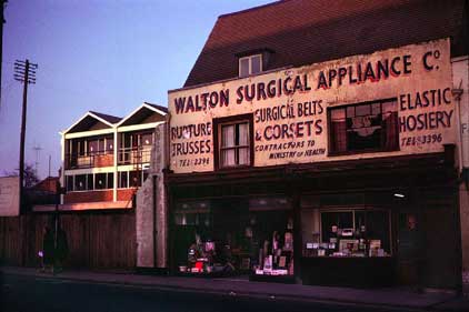
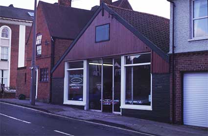
Walton Surgical Appliance Co., 42-44
St
Matthews Street
 Photograph
courtesy The Ipswich Society
Photograph
courtesy The Ipswich Society
Above: a puzzling photograph from the Ipswich Society Flickr
collection (see Links). Where on earth is
this? Is it Ipswich at all? Hang on, those buildings in the background
with the pointy tops… aren’t they part of the St Matthews Street
‘development’ in the early 60s? The ones which today stand next to the
BBC Radio Suffolk building? So this must be the part of St Matthews
Street
which was demolished to build the roundabout approaches. Difficult to
imagine today…
'WALTON SURGICAL APPLIANCE CO.
RUPTURE TRUSSES, SURGICAL BELTS & CORSETS,
ELASTIC HOSIERY
TEL: 53396,
CONTRACTORS TO MINISTRY OF HEALTH, TEL: 53396'
[The initial 5s of the telephone
numbers have been painted over.]
[UPDATE 9.12.2016: "I
can confirm that this shop was definitely in St Matthews Street. I
walked past it every day on my way to primary school. Later it was
famous for selling condoms and not asking your age! All the best and
keep up the good work. Ian Johnson." Many
thanks to Ian for this invaluable information.] Ruth Serjeant: Walton’s shop was in St. Matthews Street, nos
42 /44 and is listed for the first time in the 1932 Ipswich street
directory, and was still listed in the 1975 one (which was the last one
published). It must have disappeared soon after that, for the changes
at the west of Berners Street. Peter Brockett: Next door at 46,
which is the building demolished but whose remaining part wall is seen,
was ‘The Golden Fleece Hotel’.
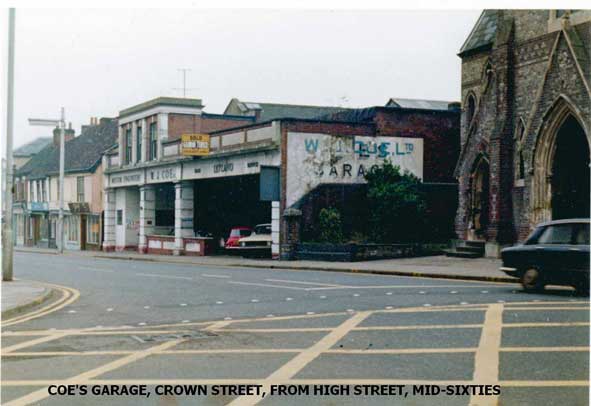
Coe's Garage, 15 Crown Street
 All
photographs courtesy John Bulow-Osborne
All
photographs courtesy John Bulow-Osborne
The deco-style building next to the church (both now demolished)
on the corner of Crown Street and High Street bears the lettering:
'MOTOR ENGINEERS ... W.J. COE LTD. ... LEYLAND'
and what may be 'SALES' and 'SERVICE' in small characters either
side of 'Leyland'.
The end wall has degraded painted lettering:
'W.J. COE LTD. [in turquoise] with partially underneath that:
'SALES[?]
GARAGE'
The garage bears the yellow 'SOLD' estate agent board of Garrod
& Turner, so although cars are still in evidence (a red Leyland
Mini and a cream Ford Cortina, we think), it wouldn't be long before
the building emptied and was presumably demolished to make way,
eventually, for the long-empty General Accident block of today. Which
do you prefer? At the right is Crown Street Congregational Church, a
fine Grecian-style building standing on the corner with High Street
(the congregation migrated to Christ
Church in Tacket Street) which was also due for destruction at this
time.
 1959
images
1959
images
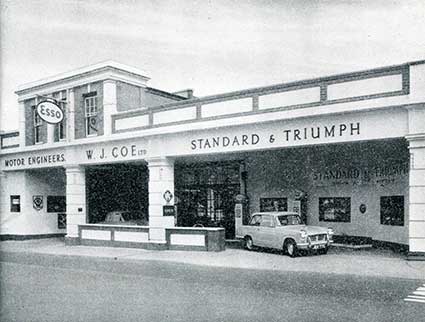
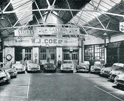
[UPDATE 7.3.2018: 'Just
wondered if the attached two images are any use to you. They came from
an advertisment in an old East
Anglian Magazine... Perhaps they are already on that wonderful
cornucopia that is your website? For about a year, in the early
sixties, I worked just across the road from Coe's Garage [W J Coe Ltd,
15 Crown Street], and went in occasionally. I recall the petrol pump
attendant - a now extinct species - called Tommy: a real hard nut, and
a Geordie... All those lovely Triumph TRs were lined up for the
photographer, I suppose. Certainly, I never witnessed such an array, or
the floor looking so clean...' Many
thanks to John – at this time the word 'Leyland' in the top photograph
of W.J. Coe is replaced by 'Standard and Triumph'.] We
learn that the company existed here from at least 1936 to 1965 selling
Standard, Triumph, Vauxhall and Opel. Leyland Motors
Ltd bought Standard and Triumph (Standard-Triumph International
Limited), cars, vans and some agricultural machinery interests in 1961,
eventually to become British Leyland (later BL).
Crown Street from Lady Lane
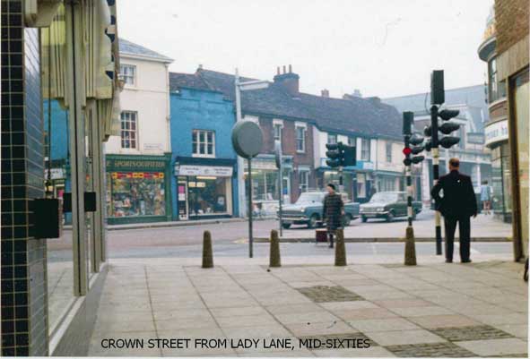
O brave new world, thy name is pedestrian precinct. Although not
crammed with interesting signs, this photograph from the jaws of the
newly modernised Lady Lane indicates how
close the shops were on the other side of St Mathews Street and Crown
Street in the mid-sixties (probably around the line of the current
central reservation). The future beckoned: dualling the carriageway,
demolishing these business premises (including Coe's Garage visible to
the right behind the man) and stopping traffic from using this upper
part of Westgate Street.
7-9 Woodbridge Road, motor works &
Ipswich Caribbean Association
7-9 Woodbridge Road, which was Crawley's Garage before it became
the Clutch Centre in the photographs (empty at this time). Next door
is, of course, the old Territorial Army Centre, later the ICA (Ipswich Caribbean Association).
The wider view below is very different to that seen in 2018: the
traffic island has been reduced to, more-or-less, street level without
the tree and the two featured buildings are long gone to be replaced
by... a car park. The restaurant and shops to the right still stand.
68a Norfolk Road, corner with Suffolk
Road
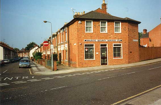
Majestic Security Services, established by the late David Woolf
and subsequently run by his son Richard, who later sold the business.
In 2018 this property is private accomodation. On the opposite corner
to this building (behind the photographer to the left) is the lettered Suffolk Road Stores.
Kent Blaxhill, Wolsey Street
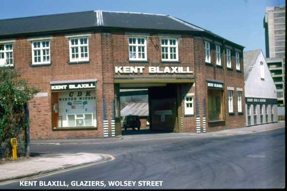
Kent Blaxhill decorating, glass & building supplies still
trade from Trinity Street, off Duke Street. Note the
modern version of the carriage entrance. The Greyfriars
block development can been seen in the background.
The Zulu Inn, Wolsey Street
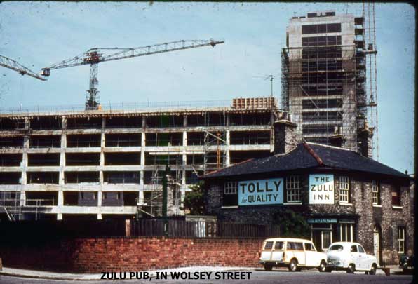
The Greyfriars complex (built 1964-66) towers in its skeletal
state above a public house which must bear one of the strangest names
in the town, if not the country:
'TOLLY
for
QUALITY'
'THE
ZULU
INN'
With 'TOLLY' above the door, all black lettering on sky blue
ground. The Zulu Inn was formerly called The Cardinal's Head closed in
March 1965 and the building was demolished. The Battle of Rorke's Drift
was a January 1879 battle in the Anglo-Zulu War (the
1964 feature film Zulu was
based on the events). It may be that these events were
the first time that the name 'Zulu' came into common parlance and it
was attached to the public house. Licencee documentation does not name
the business 1874 until 1900 when the 'Zulu' name appears. The Suffolk
CAMRA website (see Links) tells us: 'Mrs E.
Wright was the last landlady [of the Zulu Inn] and also was landlady
here for over 50 years. She also had 6 children, 4 of whom were girls
who later also ran Ipswich pubs, an extraordinary family achievement.'
(For a slightly later photograph of the post-Zulu Inn location from a
similar viewpoint, see our Water in Ipswich
page under 'Little Gipping & Great Gipping Streets'.)
Wolsey Street / Commercial Road
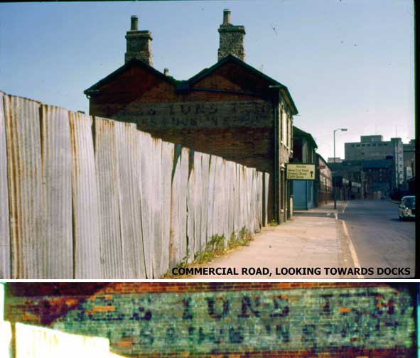
The painted sign on the brickwork reads:
‘THREE TUNS INN'
beneath this we thought it might be : 'ALES WINES & SPIRITS’
but perhaps it is more likely to be:
'ALES & DUBLIN STOUT’
The Tun (Old English: tunne, Latin: tunellus, Middle Latin:
tunna) is an English unit of liquid volume (not weight), used for
measuring wine, oil or honey. Typically it is a large vat or vessel,
most often holding 210 imperial gallons. In descending vat size from
the Tun: Pipe or Butt, Puncheon or Tertian, Hogshead, Tierce, Barrel,
Rundlet.
The modern road sign reads:
'Docks
New Cut East
Orwell Quay
Cliff Quay'
and further down Commercial Road (now called Grafton Way), an
industrial building bears prominent white capitals; 'William Brown',
see below. In the distance is the burnt-down-and-demolished R. & W.
Paul maltings on St Peter's Wharf with the concrete silo behind it.
Further views of the lost Paul maltings (notably taken by John)
can be found on our Trinity House buoy page.
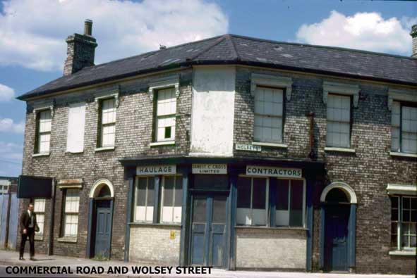
Above, the former Three Tuns public house at 79 Commercial Road
with its 45 degree angled corner entrance is in use as 'ERNEST C. CROSS
LIMITED: HAULAGE CONTRACTORS'. The white-painted areas on the upper
floor would probably have born the pub and brewer's names. The
pub closed in the 1940s and for a time was used as a canteen by timber
merchants William Brown.
[UPDATE 22.10.2016:
"Fantastic to see a picture of the old sign denoting my great
grandfather's business that he ran from Ipswich after WW2. Ernest
C. Cross Haulage Contractors. 79 Commercial Road.
He also had a garage on Anglesea Road - I wonder if you have come
across it? Thank you for looking after the past. Sally O'Brien" Thanks to Sally – is this the garage...?]
 1980s
1980s
 2019
2019
Above: Peter Blackburn Cars at No 11 Anglesea Road in the 1980s; photograph courtesy The Ipswich Society
Image Archive. Above right: a similar view in
2019, the showroom building replaced by a house.
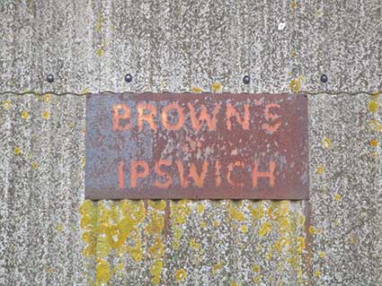
William Brown Timber Importers
On the opposite corner of Wolsey Street and Commercial Road
(visible in the first Three Tuns Inn photograph above) is the
blue-painted building shown below, which was City Electrical Factors
(with a red hanging sign). The other was the much-lettered: William
Brown Timber Merchants, of hallowed memory:
'WILLIAM BROWN & CO. (IPSWICH) LTD.
TIMBER IMPORTERS ... BUILDERS MERCHANTS'
with what might be a telephone number and 'Commercial Road,
Ipswich' at the far end in small characters.
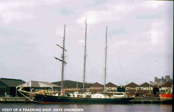
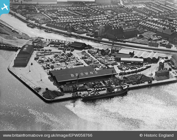
Below: the 'William
Brown & Co. (Ipswich) Ltd. Timber Importers'
lettering reappears on a dockside wharf behind a visiting training
ship. This looks like Timber Quay (see our Wet
Dock map page) seen from the eastern quays with the cooling vents
of Felaw Maltings just visible over the rooftops (centre) and the
concrete silos of St Peters Wharf to the right.
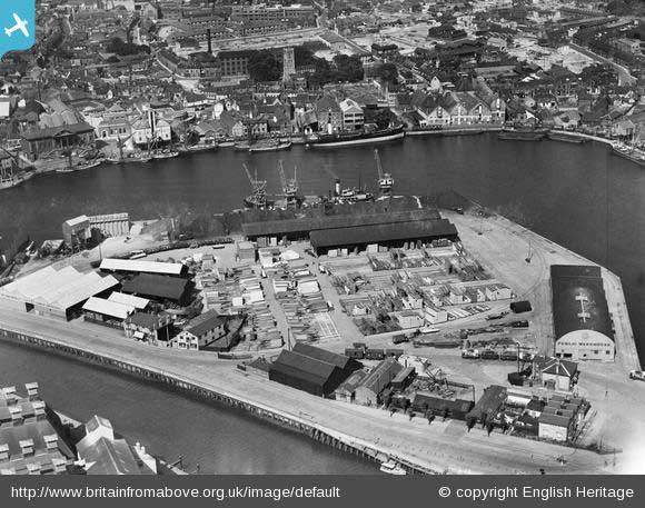
Below left: The William
Brown & Co (Ipswich) Ltd timber works, Wet Dock
and environs, Ipswich, 1938. This image is taken from the
excellent Britain from above
resource (see Links). The 'Public Warehouse' lettering is visible to the
lower right with the Harbour Master's office below that. The Custom House is visible at upper left;
to the right on Common Quay is the Isaac Lord
complex. At lower left are the vents of Felaw Maltings on New Cut West.
The 1938 photograph taken from the opposite direction (above
right) shows that Brown's were determined to market themselves to
aeronauts, too.
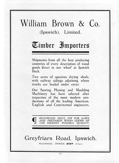 1936
advertisement
1936
advertisement
Note also that William Brown operated at one time from a timber
yard in Key Street, as shown on a monochrome photograph of The Old Bull
Inn dated '1970s' on our Burtons page.
[UPDATE 24.1.2017:
Below is a photograph from a contributor to this website of a William
Brown van in Debenham dated April 1965. “Apparently the roof tiles were
delivered on 13th April, and by the following day they were all in
place. I wish the builder had hung his jacket on the front of the van,
then the whole sign would be visible!
‘WM. BROWN & CO.
(IPSWICH) LTD.
ROOFING DEPT.
TEL. 56761.’
(the side of the van reads 'TILING & SLATING CONTRACTOR')
… I wanted to find out more about the little Morris 1000 van in
this photo, and why it was parked outside the bungalow. When I Googled
the name William Brown of Ipswich I found the details on your website.
William Brown was a builder's merchant and the company later became
Jewson. Jewson has remained on the original Wm. Brown's site in Wolsey
Street.” Many thanks for the
contribution.]
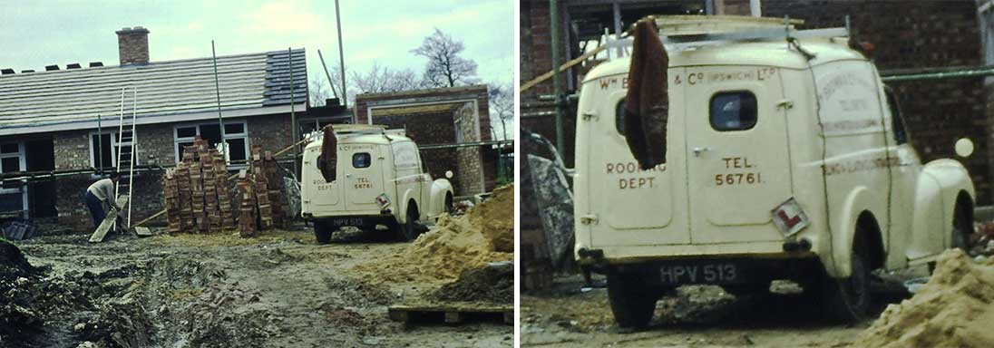 1965
1965
[UPDATE 23.11.2020:
while on a circular walk from Shingle Street to Alderton
and back the sign 'BROWN'S OF IPSWICH' below was noticed on a barn at
Buckanay Farm. One assumes that this refers to William Brown & Co.
timber merchants of Ipswich. The corrugated asbestos cladding is,
presumably, attached to a timber frame.]
 2020
image
2020
image
The Friars Head, Friars Road
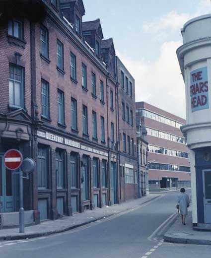
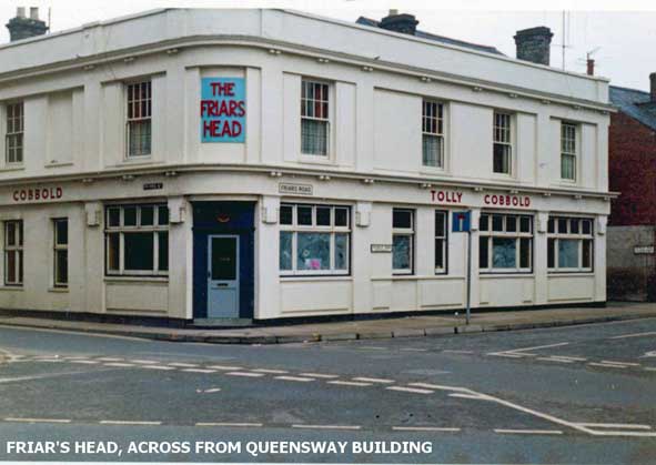
On the corner of Friars Street and the now-disappeared Friars
Road (at 33 Friars Road) is the quite smart frontage of a public house:
'THE
FRIARS
HEAD'
in raised red capitals against a sky blue background on the
curving first storey area above the corner entrance (note, no
possessive
apostrophe) with, above the ground floor windows on each elevation:
'TOLLY COBBOLD'
so the sign post-dates the amalgamation of the Tollemache and
Cobbold's breweries in 1957 to make Tolly
Cobbold. The pub closed in 1972 and it looks by the
whitewashed windows that this photograph dates from that time. The
Willis building was built on this site, constructed between 1970 and
1975.
In the view down Friars Street, opposite The Friars Head is
Queensway Warehouses featuring carpets and bedroom furniture. The
one feature in the above left photograph which can still be found,
quite dominant in Friars Street, is the stripy brick and glass block
known as Giles Place (shown below, photographed from outside Willis).
Today this connects with the rear of Century
House in Princes Street and runs up to Coytes Gardens (see that page for its
relationship to this old, limestone sett street).
 Giles Place, 2017 image
[UPDATE
3.7.2023: 'A comment about Grimwade Ridley & Co, in Friars St.
There were two buildings which sat on opposite sides of the road. The
building on the left of the picture (Queensway Warehouses) was
originally one of the Grimwade Ridley buildings prior to being sold to
Queensway in the late 1960s. The building shown below was the one I
remember, which I thought was behind the Friars Head pub. David
Howlett. Thanks to David for the
contribution – and that below.]
Grimwade Ridley & Company Ltd.
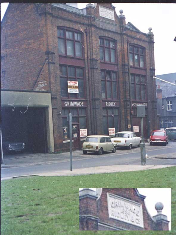
The tablet at the top of the building reads:
'GRIMWADE
1898
RIDLEY & CO.'
Grimwade Ridley & Co. Ltd. were wholesale druggists; their
salerooms and offices were in Princes Street, opposite The Friars Head;
they were demolished and replaced by the Willis building in modern
times. However, the building shown above – a warehouse? – doesn't match
other views we have seen. We wonder where this was situated. Grimwade
Ridley & Co. (Ipswich) Limited was registered on Saturday December
7 1929 but was dissolved post-1988.
"The long talked-of Swimming Baths for St. Clements [Ipswich]
have at last been commenced at a cost of £3,468. Messrs.
Parkington and Son of St. Margaret’s Works have demolished the premises
once owned by Grimwade, Ridley & Co …The pool is to be 70ft. long
with six slipper baths on either side. When finished, it will be
a very welcome addition to the neighbourhood." (Ipswich Journal February 25 1895)
This reference to the buildings which stood where Fore Street Baths now stands may explain
the above image, although they could, of course, have had more than one
place of business. Significantly, this building bears an 'Acquired for
clients' estate agent's board, suggesting that demolition was imminent.
[UPDATE 8.1.2014: 'As for the
Grimwade Ridley building, you were nearly right. It actually stood just
behind the Friars Head, the rear elevation of which is just visible to
the right-hand side of the picture.
John Bulow-Osborne']
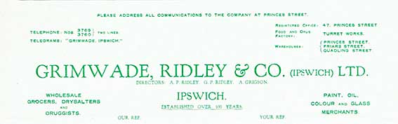
[UPDATE: 15.4.2018: 'Re: the
picture of Grimwade & Ridley on the website: this letter head from
the 30's gives addresses of various of the Grimwade warehouses, Turret
Works, Princes St, Friars St, Quadling St. Kate Chenneour.' Many thanks to Kate for spotting this
intriguing letter (full transcript below).]
 1939
letter
1939
letter
“Please address all communications to the company at Princes Street.
Telephone: Nos. 3769 / 3760 } two lines
Telegrams: “Grimwade, Ipswich.”
Registered Office: 47, Princes Street
Food and Drug Factory: Turret Works.
Warehouses:
Princes Street.
Friars Street.
Quadling Street.
Grimwade, Ridley & Co. (ipswich) Ltd.
Directors: A.P. Ridley, G.P. Ridley, A. Grigson.
Wholesale Grocers, Drysalters and Druggists.
Paint, Oil, Colour and Glass Merchants.
IPSWICH.
Established over 100 years.
Manufacturers of quality [GR] products highest grade packed foods and
drugs.
24th July 1939
The Ipswich Water Works,
Ipswich.
Dear Sirs,
With reference to your Quarterly Account, we notice that you are
charging for Friars Street Factory nearly double the last quarter,
working out at the rate of about 2000 Gallons per day. We are quite
convinced that we are not using anything like this quantity of water
and shall be glad, therefore, if you will kindly investigate.
Yours truly,
GRIMWADE, RIDLEY & Co. (IPSWICH) LTD.
A.P. Ridley Director.”
Tag:
“In the event of a reply being necessary please detach at perforation
and attach to letter. … A.P.R.”
Before Willis
John's photographs of this part of Ipswich prompts us to look at the
area
before the Greyfriars development and before the Willis, Faber &
Dumas building swallowed a fair bite of the town.
 1902
1902 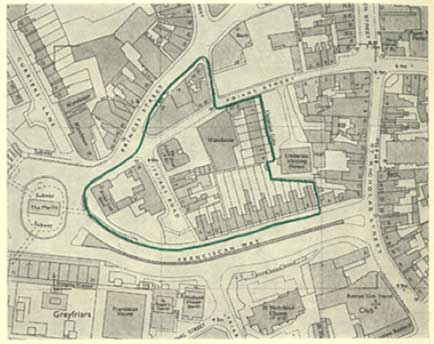 c.1973
Above left: Here we are
in 1902: a very different street pattern
to the twenty-first century's Civic Drive, ex-Greyfriars blocks (built
1964-66) and, of course, the Willis building (built 1975). This area
has been the focus for many changes over centuries. The red line
indicates the proposed footprint of the Norman
Foster/Michael Hopkins smoked glass Willis offices. In the end, some
housing on the north of Cromwell Street (now called Cromwell Square)
was saved and the 'Unitn. Chap.' (the Unitarian Meeting House, Listed
Grade I) was not so hemmed in. Above
right: the map fragment shows the initially
planned
footprint of the Willis building superimposed on the post-Greyfriars
street layout.
One or two interesting features can be spotted:-
- 'Grey Friars Priory (Remains)'
to the west of St Nicholas
Church with 'Priory Wall' in Gothic script '(Rems.)' lining Friars Road
– which no longer exists – opposite the church. These remains were
dismantled and moved to Christchurch Park.
During the Greyfriars precinct development in the 1960s they were
returned and some
fragments
of stonework can still be seen set into the concrete wall of Franciscan
House.
- Further up Friars Road on the corner with Friars Street is
'P.H.': The Friars Head public house shown above on this web page.
- The nearby 'Hotel' is the British Lion Hotel, a
substantial three storey building fronting Edgar Street, which was
still standing next to the
large Civic Drive roundabout (only removed in 2012) and looking out
over the Greyfriars development from 1966 until its demolition to make
way for Willis.
- The density of housing to the west of St Nicholas Church
in Edgar Street, James Street, Portman Street, Priory Street and – the
only one to survive clearance – Cardinal Street.
- 'St Nicholas Church Lane' is labelled between Cromwell
Street and the Church of St Nicholas. Similar to St Clement Church Lane (which can still be
found to the east), St Nicholas Church Lane disappeared
with the terrace of houses to the south of Cromwell
Street. That expanded street became first a dual carriageway as part of
the planned Ring Road (which never
progressed across St Nicholas
Street, due to protests by the fledgling Ipswich Society),
then 'Cromwell Square' – a car park.
- There is a 'P.O.' (Post Office) in St Nicholas Street
close to the Cutler Street junction.
- Tanners Lane, home of C.
Mills & Co. 'St Nicholas Foundry' found on many drain and
manhole covers in the town, can be seen at top left of the map. Tanners
Lane disappeared beneath Civic Drive.
- The road maintaining its position (more-or-less) amidst
all the upheavals to come is Princes Street, running diagonally from
the top to the west. It has the tramway lines showing the route from
Cornhill to the railway station. Ironically, Princes Street had itself
around 1860 been brutally cut diagonally through the old pattern of
lanes, houses and gardens to open up this route.
- Running northwards from Friars Street to Princes Street is
the right-angled Coytes Gardens (which
still exists) and, west of it, the remnant of Thursbys Lane, which
once ran from Friars Street up to Elm Street; it was cut in half by
the building of Princes Street. Museum Street was cut
southwards through the site of the Thomas
Seckford's Great Place in Westgate Street in
the 1840s (and turned a right-angle, later to become Arcade Street
when an opening – the 'arcade' – was cut through); Thursbys Lane was
extended to meet Museum Street in 1856 and the whole stretch was
renamed 'Museum Street'. The last bit
of the lane shown on the 1902 map was lost in the 1970s as the line of
the Willis building can be seen to
run up it. Death by a thousand cuts for Thursbys Lane. See also our King Street page for the way in which
Arcade Street fits into this story.
- At the left of the 1902 detail is the end of Friars Bridge
Road, once an important link by causeway across the marshes in this
area, now a tiny elbow leading nowhere.
See our Civic Drive page for a
fuller view of the 1902 road layout with modern streets overlaid.
See our Museum Street page for 1778
and 1902 comparative maps including this location.
See
our 'Ipswich Tomorrow' page for
more about the Greyfriars and Willis developments and the
Greyfriars timeline.
After Willis
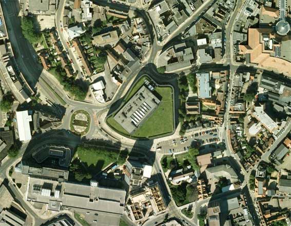
This birds eye view of the Willis building (centre) before the
Greyfriars roundabout was removed in 2013 as part of the Travel Ipswich
project shows the grass-covered roof of the glass-clad building. The
double roof of the Unitarian Meeting House can be seen directly to the
east of it with the three remaining Cromwell Street (now Cromwell
Square, a car park) houses below that.
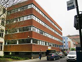
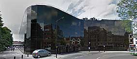 The Willis
building today
The Willis
building today
See also our Willis monolith
page for the obelisk which marks 800 years of Ipswich history.
John also send these two views
of the island of buildings west
of Friars Road and The Friars Head pub.
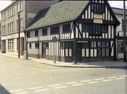
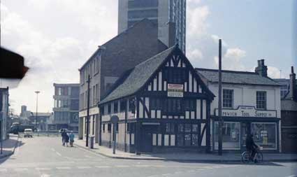
John writes: 'Behind the "Half-Timbered" building are the premises of
the Walpamur paints company. I might be correct in stating that Brian
Jepson had a hand in its design.' The photographs must have been taken,
looking south, from the original Friars Street, the route of which was
changed during
the Willis development, but still exists. The street nameplate on that
mock Tudor, but rather handsome (with carved cornerpost), building
reads 'Friars Road'. Next is
the Ipswich Tool Supply Co. The British Lion Hotel would be to the
right of these views. In the background are the
Greyfriars blocks including the logo
of the Midland Bank (later swallowed by HSBC) branch on the low-rise
building. All of these buildings in the foreground were swallowed by
the Willis development about ten years later.
See also our Collage
of lost signs and The Ipswich Society's Flickr-based slide
collection of vintage Ipswich views (see Links).
©2004 Copyright
throughout the Ipswich
Historic Lettering site: Borin Van Loon
No reproduction of text or images without express
written permission