The car park which occupies the site between the eastern quays of the
Wet Dock and Duke Street (south of the Neptune Marina block – see
our Wet Dock map if you're confused)
is
apparently owned by University Campus Suffolk and in 2013 is on the
back burner for further development of the university. This gives us
the chance to see the remnants of the Ransome's
Orwell Works: one of the greatest engineering works
in Ipswich – if not Britain and beyond. Almost everything to be found
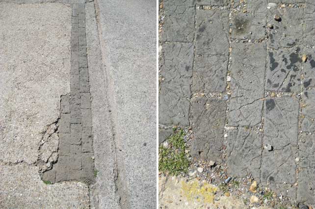
is at ground level, visible amongst the uneven patchwork of concrete
and asphalt.
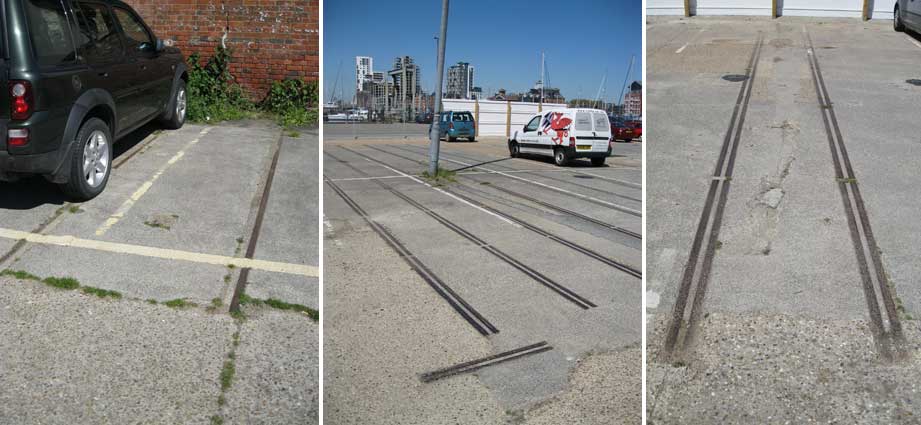
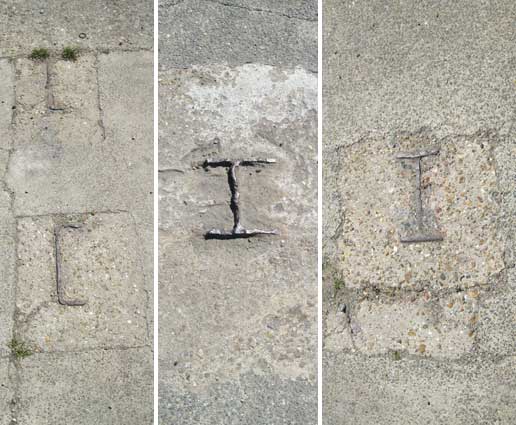
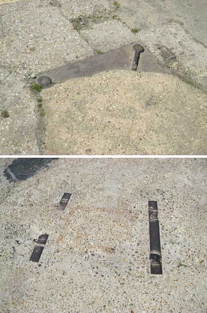
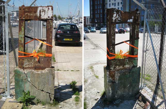
On the ground 2013
images
Industrial archaeology is normally covered in some way, but the
merest remnants of the Orwell Works are being walked and driven upon
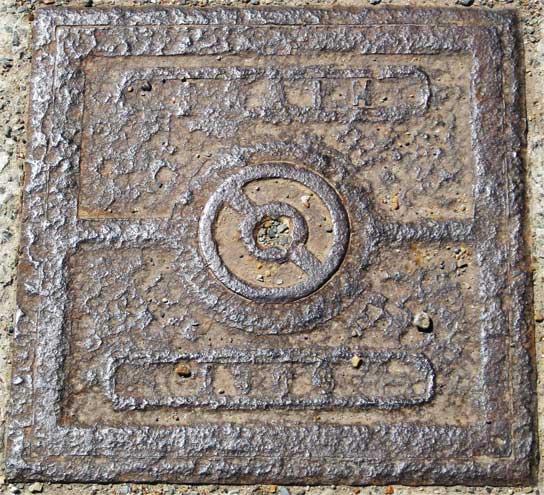
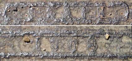
every day. Here is the only piece of historic lettering found:
'DRAIN
1308'
It was certainly tempting to
think that the bottom number was a date (1908), but close inspection
shows the '3' pretty clearly (see close-ups below).
Sections of end-grain wood block flooring.
Distressed internal wall of the Ransome works. A thick steel sheet
almost covering a man-hole.
Dockside tramway
Clear evidence that the tramway came right inside the works. See
the criss-crossing tramway lines preserved on the 'The
island'. Many ground level features there, too.
'I' and 'U' section iron girders set into the concrete, then later cut
off at ground level.
Traces of iron surrounds partially covered by patchwork concrete.
And what on earth is this rusting iron oblong on a chunk of
crumbling concrete? Decorated with 'hi-viz' safety tape for the summer
solstice. Probably.
On the map White's map of
Ipswich 1867; the
detail below shows the extent of the Ransomes Sims & Jefferies
Orwell Works site at the height of the Industrial Revolution. Comparing
this with the 1881 and modern maps of the area on our Ransomes page proves fruitful:-
1. To the north is 'St Clements'
(at one time called 'St Clements Fore Street'), today called Fore
Street; it leads
into 'Wykes' (elsewhere labelled 'Wykes Ufford Hamlet' – today's Back
Hamlet) and 'Wykes Bishop Hill' (today's
Bishops Hill). The unlabelled Coprolite Street
runs off Duke Street (close to the 'D'), eastwards to the dock with the
Packard Manure Factory (here marked 'Factory') below it and the Steam
Packet Tap above it, as shown on the Fore
Street'1620' page.
2. The
'Gas Works and Depot' is south
of the two Ransomes 'Orwell
Works' sites (which sit either side of Duke Street, John Street and
'Foundry Road'. The last of these had disappeared by 1881. Today's
Maude Street and Patteson Road are on the site of the gasworks. Not
shown on this map is the gasworks quay inlet which was once cut into
the east bank for the unloading of coal. Here we see that Myrtle Road,
which today stops at the roundabout on Duke Street/Holywells Road, used
to run westwards all the way to the dockside (today this section is
Patteson Road). While the name 'Maude Street' has been reused in the
modern housing development, the appellation 'Patteson Road' appears to
be a more recent naming.
3. Further south, 'Cliff
Road' runs past the bodies of
water in today's Holywells Park, clearly visible. A
second road 'Clifton Road' branches off the same junction with Myrtle
Road. This can be seen as the main southerly access to
the St Clement's Shipyard just outside the lock and the Cobbold
Brewery (originally known as 'The Cliff'; the large Victorian tower
brewery building did not appear behind it until 1894). The most
probable solution is that the junction with Myrtle Road is today's
roundabout, 'Clifton Road' is now called Cliff Road and 'Cliff Road'
has been renamed Holywells Road in modern times when the road system –
and in particular Duke Street – was radically reshaped.
4. Quay and wharf names, the
Promenade (see also below). 'Common Quay' stretches from the
Custom House
more-or-less right round to Coprolite Street. No sign of 'Neptune Quay'
at this time. 'Ransomes Wharf' takes up much of the eastern quays,
suggesting the dominance of shipping visiting the Iron Works.
Interestingly, the dockside we now call Helena Road (see Street name derivations) is a
treed area labelled 'Marine Promenade East'; while many people will
know about the the tree-lined walk on the Island,
south of the first
lock (still in existence in 1867) here labelled 'Marine Promenade
West', this one might come as a surprise. In fact the
avenue of trees labelled 'Mile End Road' is shown linking the two
'Promenades' across the south dam – the site of the future south lock –
and extending, on the line of today's Ship Launch Road,
to
'Clifton Road' (today's Cliff Road). Members of the
public were accustomed to promenading from just south of the western
lock – the western lock gates provided footbridges – down to the
Umbrella shelter (show as a circle on the map) and all
the way round to the Gas Works, if they so desired. No wonder some
commentators demand that the route across the present-day lock be
re-opened as a public right of way. For an
exposition of the naming of the Ipswich Wet Dock quays, see our Wet Dock map page. Not visible here is the
treed Stoke Quay promenade along New Cut West, which once ran from Dock
Street, in front of the St Peter's Workhouse
grounds, past the Steamboat Tavern and Felaw
Street and all the way down to the (long-disappeared) Bright
Street.
This is shown on the 1884 map. 1867
map
A modern bird's eye view of the area, including the remnants of
the St Clement's Shipyard – where Sailing
Barge Victor was built in 1902 – can be seen on our Ransomes page.
The Promenade 1909 image
The postcard view above shows the leafy, well-ordered and
spacious Promenade on the Island site in 1909. A valued amenity for
generations of Ipswich residents, the Promenade was laid out in the
1840s as part of the Wet Dock project. The Promenade stretched from the
original western lock, which opened into New Cut, down to the lower dam
where a cottage stood for 'the keeper of the Promenade', a large statue
of a winged horse and a shelter – whose shape gave it the vernacular
name of 'The Umbrella'. Particularly at weekends, people strolled
between the avenues of trees to view the ships in the dock and, at the
southern end, there were views over the wider reaches of the River
Orwell, Cliff Quay and 'Hog Highland' on the east bank. In 1912 the
Dock Commission planned to end the public right-of-way along the
Promenade; although the war in 1914 meant that those plans were not
carried into effect, the Promenade was eventually industrialised and it
disappeared under hard surfaces and tramway lines which led down, and
over, the swing-bridge to enable freight access to Cliff Quay and
beyond. Nobody appears to have complained when the Dock Commission
applied for the Act of Parliament which gave them powers to close the
Promenade, but its loss has been the subject of public regret ever
since. In around 2013 a public inquiry was held into the matter, but
New Cut East is still barriered off to the public as far as the
swing-bridge over the lock. [Based on information from Malster: Ipswich, an A-Z of local history,
see Reading list.]
The only other lettering connected to Ransomes
is to be found not far away in Wykes Bishop Street and in Cliff Road.
See also a page containing images of Ransomes
& Rapier.
You can see more ground-level elements of maritime Ipswich on the northern quays page and on 'The island'.
See also our Lettered castings
index page.
 2013
images
2013
images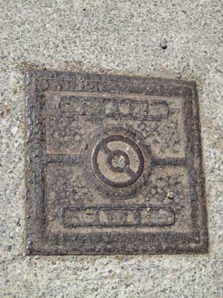

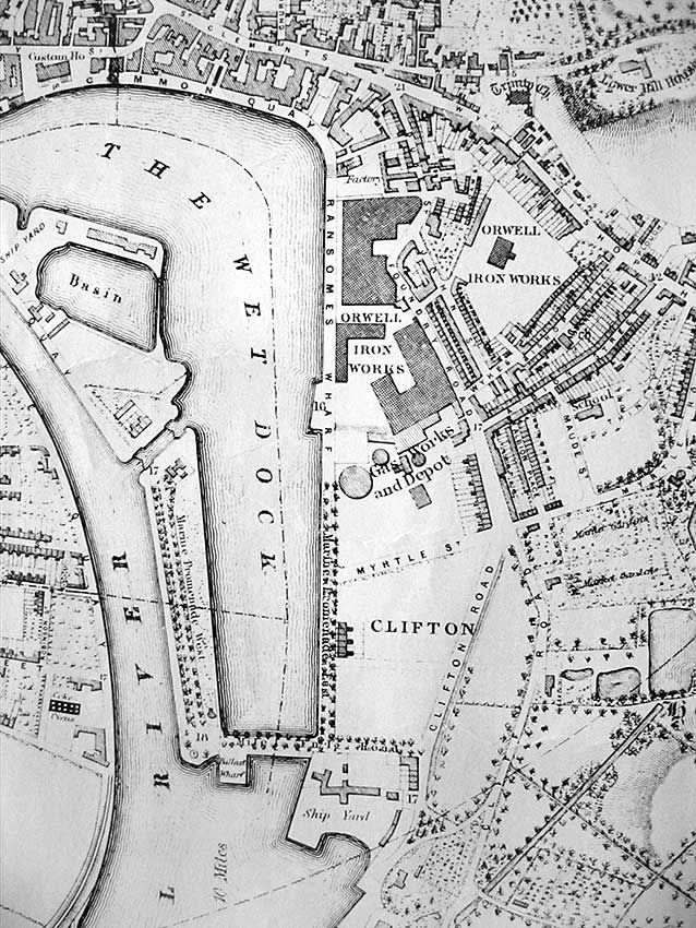 1867
map
1867
map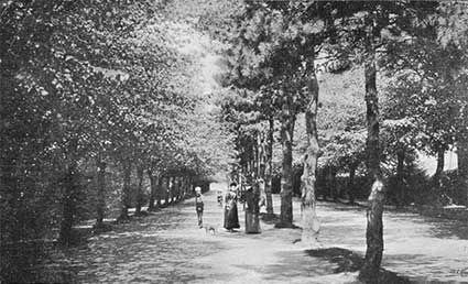 1909 image